项目简介 Project Information
巴基斯坦地震、滑坡、洪涝与林火灾害严重且多发频发,危及中巴经济走廊。项目面向“一带一路”共建国家地震、火山、高位边坡、流域洪涝和森林草原火灾等典型重大自然灾害减灾需求,针对灾害应急平台跨境部署和应用示范的国际合作要求,研制典型重大自然灾害卫星应急技术系统并在巴落地,开展国产卫星应急监测与应用示范,为国际防灾减灾贡献中国智慧和中国方案。
项目重点突破震区建筑倒塌与边坡滑塌综合自动研判、地震降雨耦合的地震滑坡链生风险识别、林草火灾风险动态识别与监测预警、流域洪涝演进SAR卫星三维信息动态提取、卫星应急聚焦观测协同规划与在线处理、应急大数据汇集清洗与灾损智能评估六大关键技术难题,为应急信息服务平台研制、境外落地与示范应用提供自主先进技术保障,提高国产遥感卫星数据及灾害知识服务在“一带一路”共建国家的应用水平、有效提升“一带一路”共建国家重大自然灾害应对能力,促进人类命运共同体健康发展。
Pakistan frequently experiences severe natural disasters such as earthquakes, landslides, floods, and forest fires, which threaten the China-Pakistan Economic Corridor. Addressing the disaster reduction needs for typical major natural disasters in countries participating in the "Belt and Road" initiative, and in response to the international cooperation requirements for cross-border deployment and application demonstration of disaster emergency platforms, we will develop and deploy a satellite emergency technology system for major typical natural disasters in Pakistan. We will conduct demonstrations of emergency monitoring and applications using domestic satellites, contributing Chinese wisdom and solutions to international disaster prevention and mitigation.
The project focuses on breaking through six key technological challenges: comprehensive automatic assessment of building collapse and slope failure in earthquake zones, identification of chain risks from earthquake-rainfall coupled landslides, dynamic identification and monitoring early warning of forest and grassland fire risks, three-dimensional information extraction of flood evolution in watersheds using SAR satellites, collaborative planning and online processing for satellite emergency focused observation, and collection, cleaning, and intelligent assessment of big data for disaster loss. These breakthroughs will provide advanced independent technological support for the development, overseas deployment, and demonstration applications of an emergency information service platform. Aiming to enhance the application level of domestic remote sensing satellite data and disaster knowledge services in countries participating in the "Belt and Road" initiative, effectively improving their ability to respond to major natural disasters. This will promote the healthy development of the community with a shared future for mankind.
项目团队 Project Team
•项目负责人:吴立新教授,欧亚科学院院士,长江学者,国家杰青
•Project Manager:Prof. Lixin Wu, Member of the Eurasian Academy of Sciences, Chang Jiang Scholar Awarded Professor (2004) and National Outstanding Youth Funds of China (2005).
项目以中南大学为牵头单位,秉持科学发展理念,积极拓宽研究视野,加强中巴国际交流合作,联合北京师范大学、电子科技大学、自然资源部国土卫星遥感应用中心、中国科学院地理科学与资源研究所和巴基斯坦旁遮普大学共同组建研发团队。项目参与人员总计87人,其中博士学位22人,硕士学位25人,学士学位39人,其他1人。
The project led by Central South University, adheres to the concept of scientific development, actively broadens research perspectives, and strengthens international exchanges and cooperation between China and Pakistan. In collaboration with Beijing Normal University, University of Electronic Science and Technology of China, Land Satellite Remote Sensing Application Center of the Ministry of Natural Resources, Institute of Geographic Sciences and Natural Resources Research of the Chinese Academy of Sciences, and the University of the Punjab in Pakistan, a joint research and development team has been established. The project involves a total of 87 participants, including 22 with doctoral degrees, 25 with master's degrees, 39 with bachelor's degrees, and 1 other.
技术架构 Technical Framework
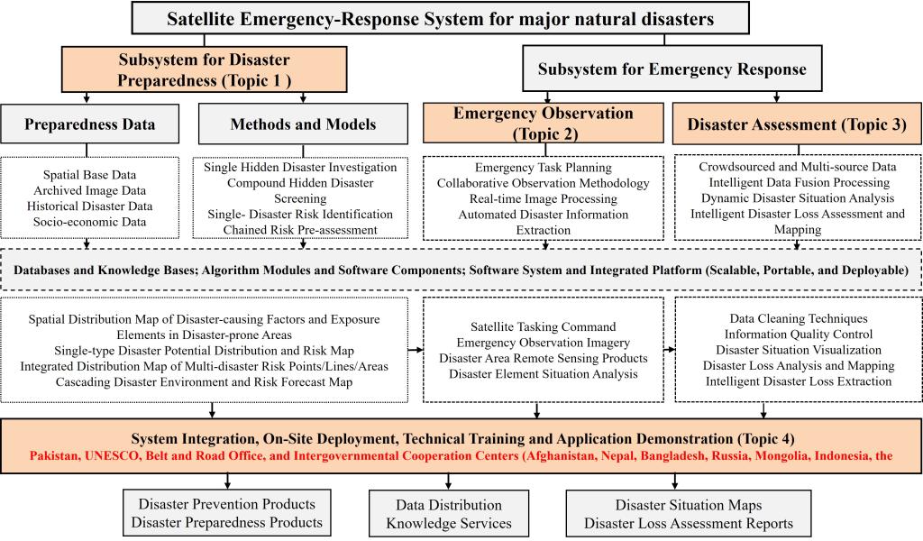
Topic 1
Remote Sensing Investigation, Risk Identification, and Comprehensive Forecasting of Disaster Hazards: Collect and analyze natural disaster data, establish remote sensing feature and recognition models, identify disaster risks, study disaster chain evolution, use dynamic information for risk prediction, and develop comprehensive risk management strategies and observation plans.
Topic 2
Disaster Emergency Satellite Monitoring and Rapid Extraction of Key Disaster Elements: Establishing emergency satellite repository and models, assessing monitoring capability, dispatching knowledge base; coordinating observation to obtain data, constructing associated model sharing services; analyzing disaster elements, building knowledge base, developing retrieval and identification models, inferring disaster distribution.
Topic 3
Multi-modal Emergency Data Rapid Collection and Disaster Damage Intelligent Assessment Technology: Study multimodal emergency data rapid aggregation and AI interaction technology to achieve comprehensive disaster information acquisition and intelligent analysis, cross-modal data fusion, disaster evolution simulation, efficient assessment of disaster damage, and support emergency decision-making.
Topic 4
Disaster Emergency Information Service Technology Platform and Application Demonstration: Based on project achievements, construct a major disaster emergency service technology system, develop unified standards and an open infrastructure, support multi-disaster emergency response, achieve data sharing and automatic service generation, promote China-Pakistan data sharing and international cooperation, and extend to Belt and Road countries.
Copyright © 2025. DRS4BR All rights reserved.