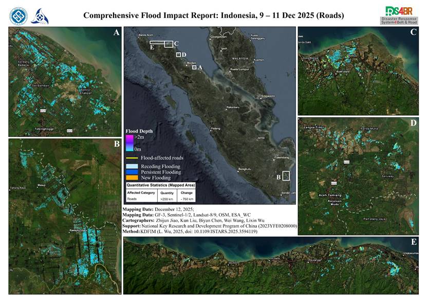
At the urgent request of the Indonesian government institution (BRIN), the disaster-response team led by Professor Lixin Wu of Central South University, Academician of the International Eurasian Academy of Sciences, conducted rapid flood monitoring and assessment across Indonesia. The initial assessment covered November 26 to December 1, 2025 (https://gip.csu.edu.cn/info/1483/8234.htm), and the...
Details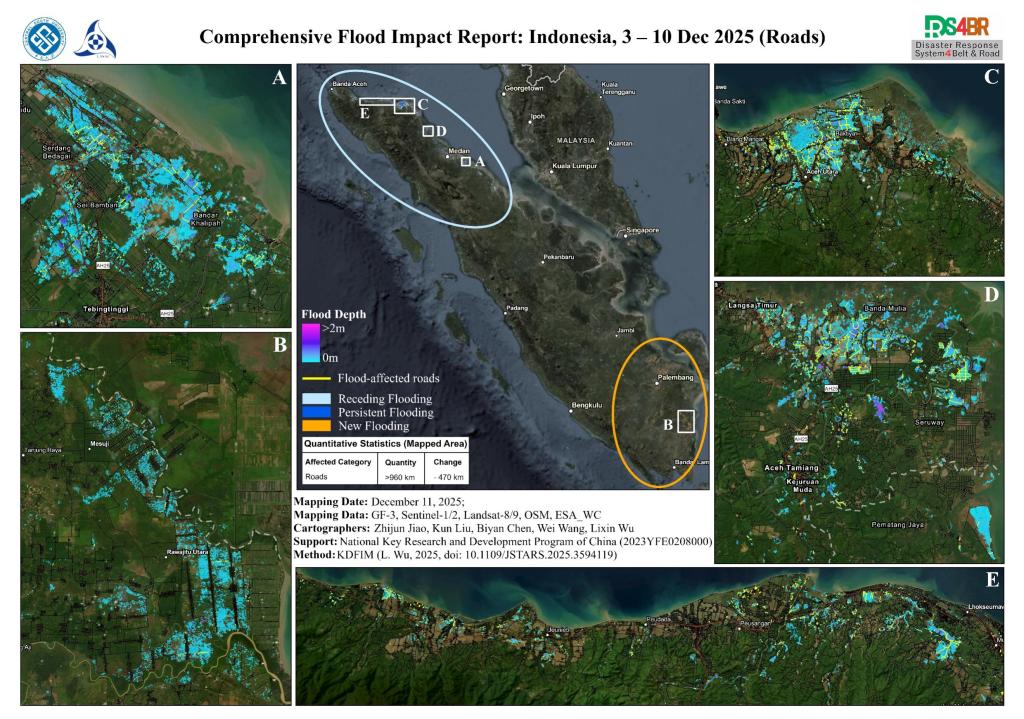
At the urgent request of the Indonesian government institution (BRIN), the disaster-response team led by Professor Lixin Wu of Central South University, Academician of the International Eurasian Academy of Sciences, conducted rapid flood monitoring and assessment across Indonesia. The initial assessment covered November 26 to December 1, 2025 (https://gip.csu.edu.cn/info/1483/8234.html), and th...
Details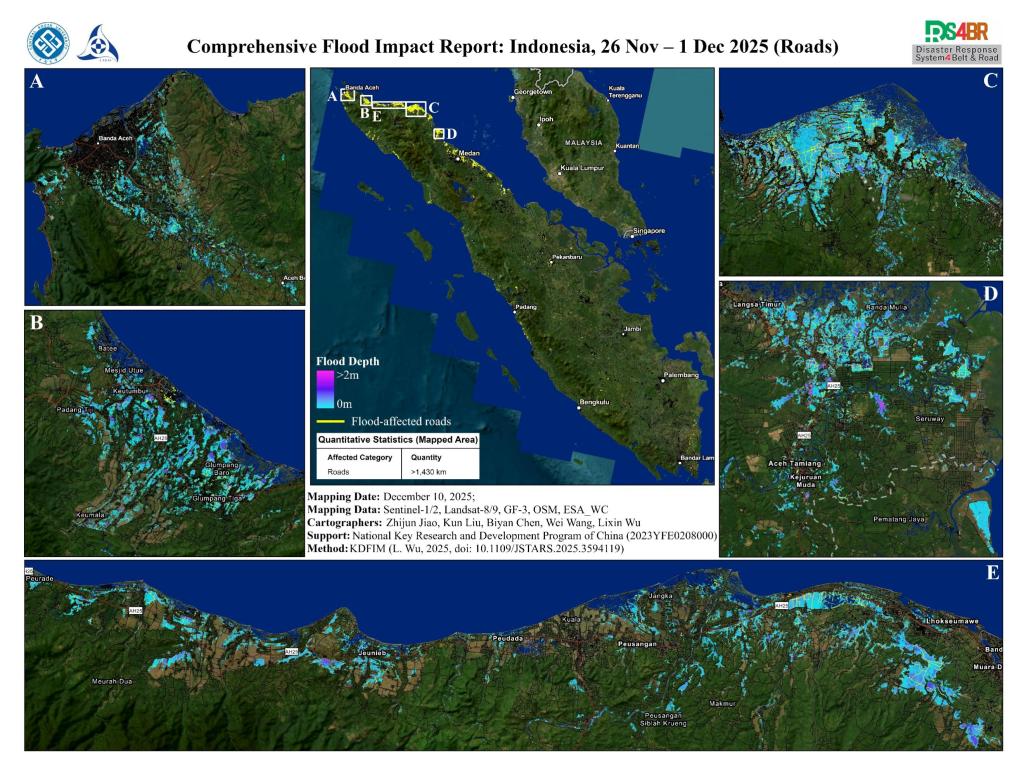
At the urgent request of the Indonesian government, the disaster-response team led by Professor Lixin Wu of Central South University, Academician of the International Eurasian Academy of Sciences, conducted rapid flood monitoring and assessment across Indonesia using satellite data from November 26 to December 1, 2025. The assessment was carried out using the Disaster Response System for the Be...
Details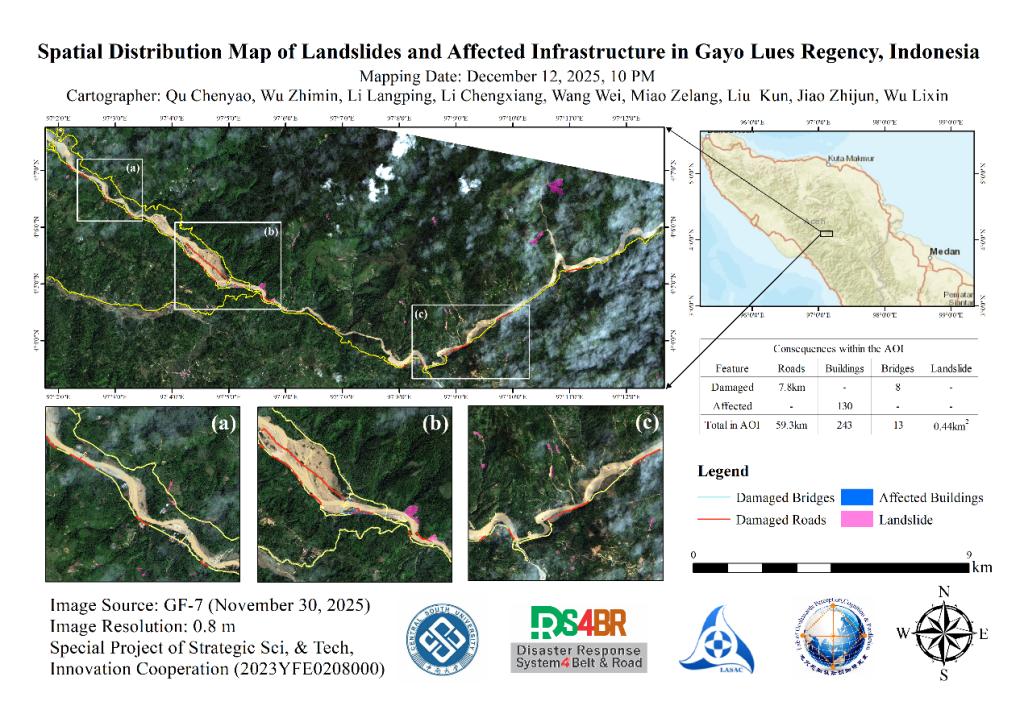
Following continuous heavy rains that began on November 22, 2025, flooding struck Indonesia's Gayo Lues Regency (approximately 4.067°–4.133° N, 97.025°–97.217° E). Utilizing remote sensing data captured on November 30 by the Gaofen-7 (GF-7) satellite, a disaster assessment was conducted through a combination of flood overlay analysis, deep learning-based landslide extraction, and manual visua...
Details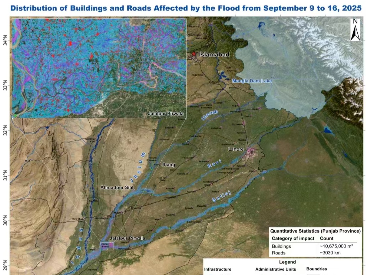
Based on multiple satellite observations on September 19, 2025 and before, we discovered the floodwaters in Sindh and Punjab are now primarily confined within the river/rivers channels, although a small portion of areas outside the channels are also inundated; and no short-term recession of the flood was currently observed. We estimated that in Sindh there are approximately 2,982,900 m² of buil...
Details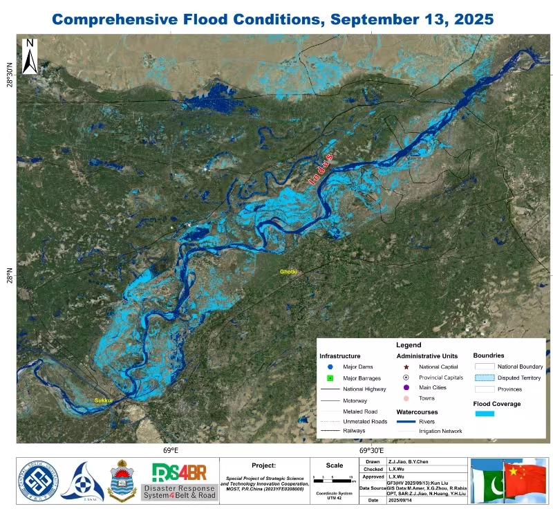
On September 13, 2025, China’s GF-3 satellite was urgently tasked to assist Pakistan in monitoring the flood evolution along the upper reaches of the Indus River in Sindh Province. Observations revealed that by the 13th, severe inundation had occurred in the river reaches upstream of Sukkur, while downstream areas of Sukkur were also beginning to experience progressive flooding of the river ch...
Details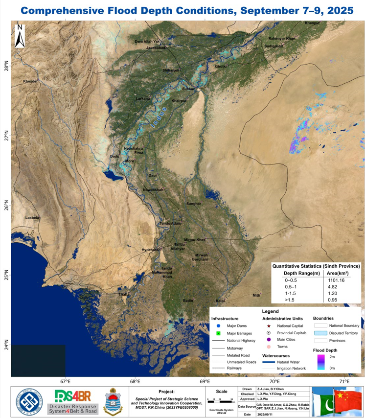
Satellite observations from September 7–9, 2025 indicated that flood inundation in the Indus River Basin of Sindh Province was relatively limited, primarily confined to the river channel. The overall water depth was shallow, with most inundated areas less than approximately 1 m in depth.2025年9月7–9日卫星观测结果显示,信德省印度河流域洪水淹没程度较轻,主要聚集于印度河河道区域,水深整体较浅,...
Details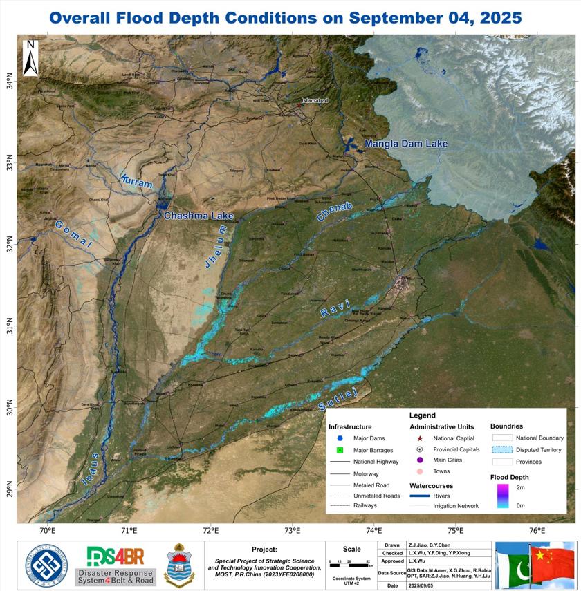
Satellite observations combined with historical information on September 4, 2025 revealed that the heavy rainfall in early September had triggered extensive flooding across Punjab Province, with the Jhelum, Chenab, Ravi, and Sutlej Rivers being most severely affected. The floods originated from the piedmont zones in the northeast and converged southwestward, producing the most severe inundation...
Details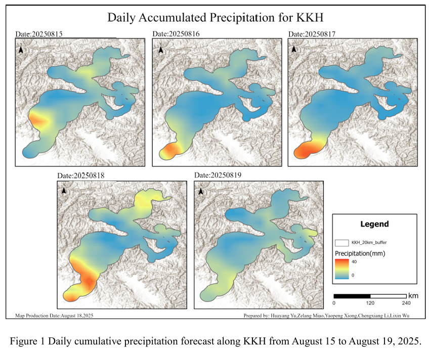
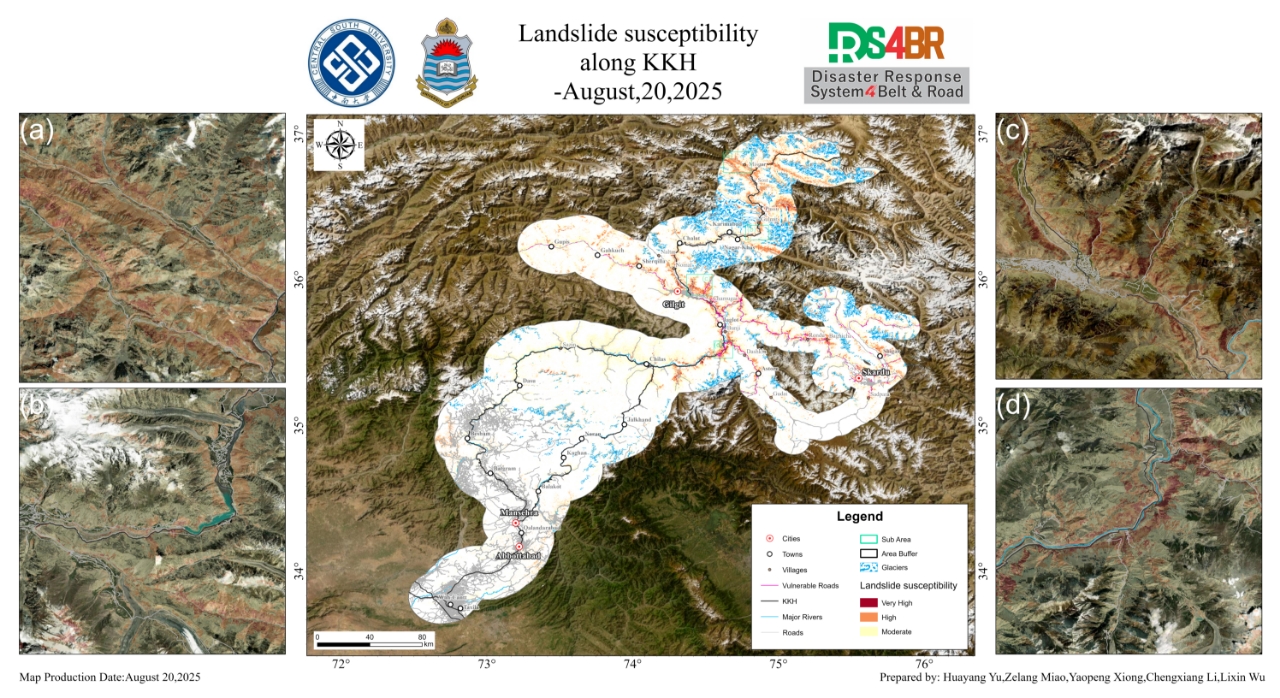
Combined with the precipitation forecast based on the NCFP GFS model onAugust 18, 2025, and multi-source data such as lithology, DEM, and hydrological conditions along the Karakoram Highway, the TRIGRS model was adopted to conduct landslide risk assessment in the northern area that was greatly affected by rainfall. The NCEP GFS forecast indicates that on August 18, rainfall along the Karako...
Details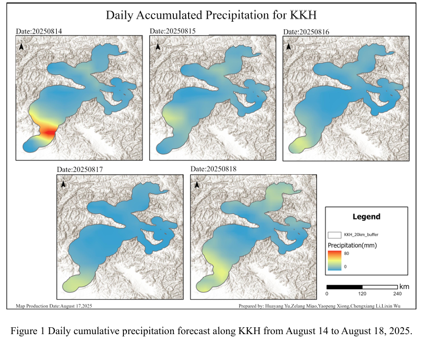
Combined with the precipitation forecast based on the NCFP GFS model onAugust 17, 2025, and multi-source data such as lithology, DEM, and hydrological conditions along the Karakoram Highway, the TRIGRS model was adopted to conduct landslide risk assessment in the northern area that was greatly affected by rainfall. The NCEP GFS forecast indicates that on August 17, rainfall along the Karako...
Details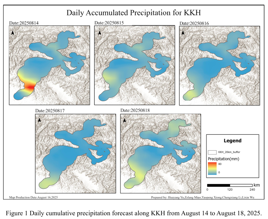
Combined with the precipitation forecast based on the NCFP GFS model onAugust 16, 2025, and multi-source data such as lithology, DEM, and hydrological conditions along the Karakoram Highway, the TRIGRS model was adopted to conduct landslide risk assessment in the northern area that was greatly affected by rainfall. The NCEP GFS forecast indicates that on August 16, rainfall along the Karako...
Details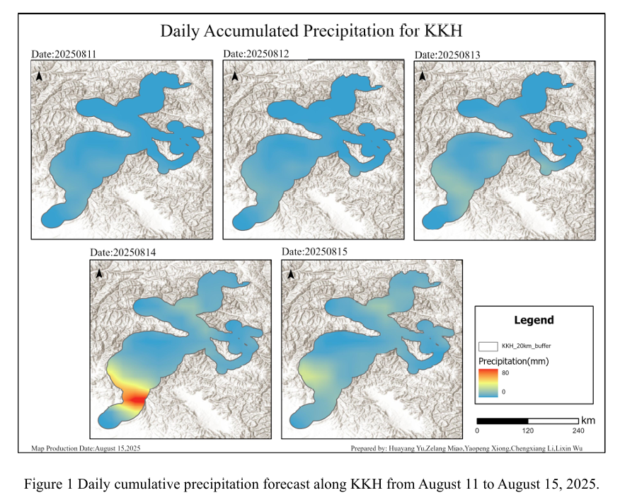
Combined with the precipitation forecast based on the NCFP GFS model onAugust 15, 2025, and multi-source data such as lithology, DEM, and hydrological conditions along the Karakoram Highway, the TRIGRS model was adopted to conduct landslide risk assessment in the northern area that was greatly affected by rainfall. The NCEP GFS forecast indicates that on August 15, rainfall along the Karako...
Details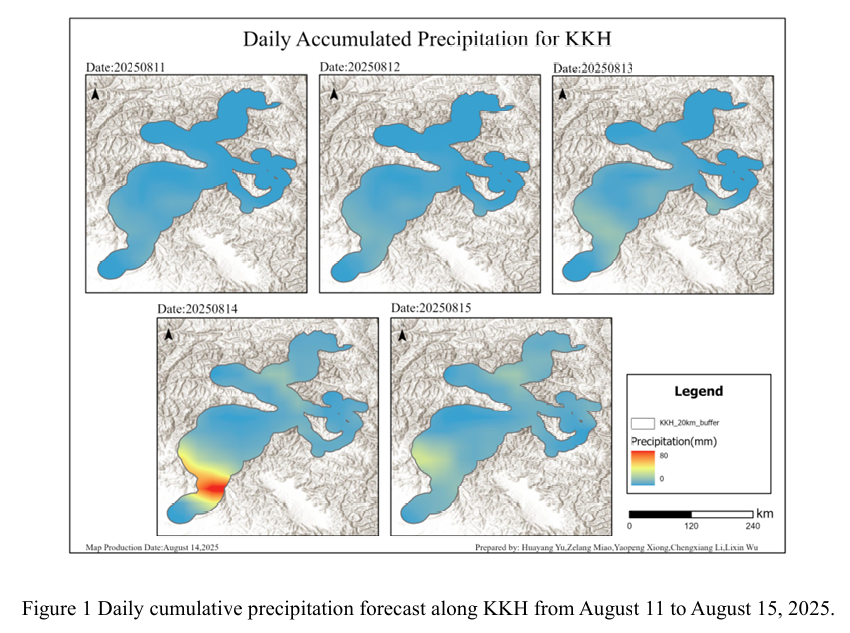
Combined with the precipitation forecast based on the NCFP GFS model onAugust 14, 2025, and multi-source data such as lithology, DEM, and hydrological conditions along the Karakoram Highway, the TRIGRS model was adopted to conduct landslide risk assessment in the northern area that was greatly affected by rainfall. The NCEP GFS forecast indicates that on August 14, rainfall along the Karako...
Details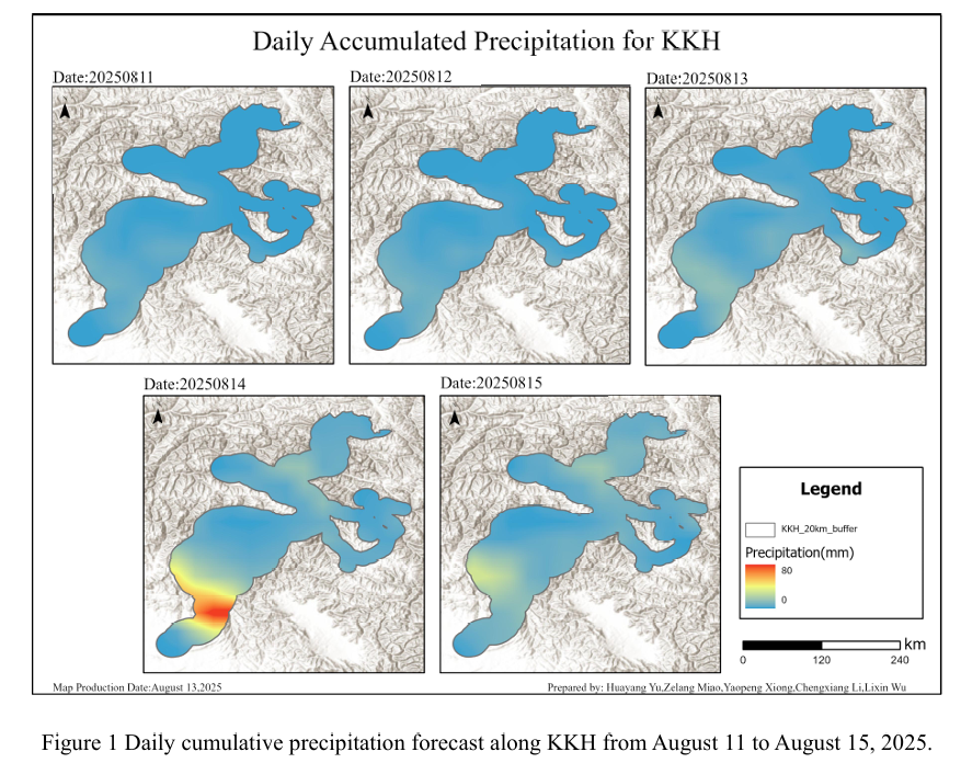
Combined with the precipitation forecast based on the NCFP GFS model onAugust 13, 2025, and multi-source data such as lithology, DEM, and hydrological conditions along the Karakoram Highway, the TRIGRS model was adopted to conduct landslide risk assessment in the northern area that was greatly affected by rainfall. The NCEP GFS precipitation forecast shows that on August 13, the overall rai...
Details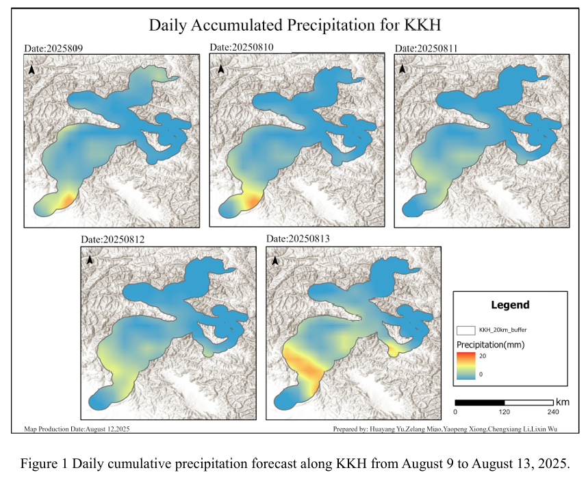
Combined with the precipitation forecast based on the NCFP GFS model onAugust 12, 2025, and multi-source data such as lithology, DEM, and hydrological conditions along the Karakoram Highway, the TRIGRS model was adopted to conduct landslide risk assessment in the northern area that was greatly affected by rainfall. The NCEP GFS precipitation forecast shows that on August 12, the overall rai...
Details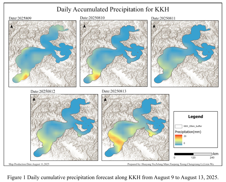
Combined with the precipitation forecast based on the NCFP GFS model onAugust 11, 2025, and multi-source data such as lithology, DEM, and hydrological conditions along the Karakoram Highway, the TRIGRS model was adopted to conduct landslide risk assessment in the northern area that was greatly affected by rainfall. The NCEP GFS precipitation forecast shows that on August 11, the overall rai...
Details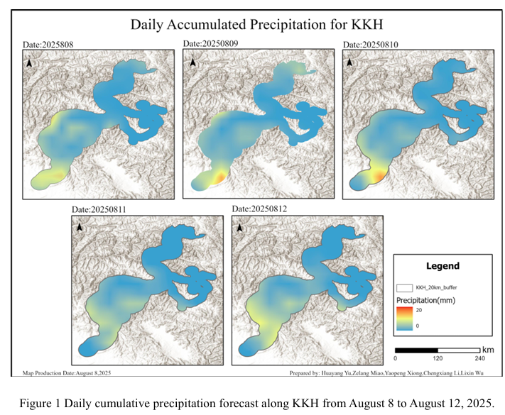
Combined with the precipitation forecast based on the NCFP GFS model onAugust 10, 2025, and multi-source data such as lithology, DEM, and hydrological conditions along the Karakoram Highway, the TRIGRS model was adopted to conduct landslide risk assessment in the northern area that was greatly affected by rainfall. The NCEP GFS precipitation forecast shows that on August 10, the overall rai...
Details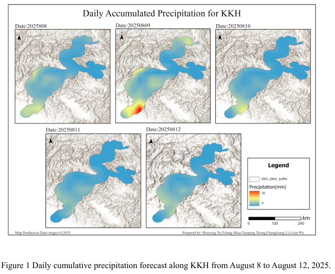
Combined with the precipitation forecast based on the NCFP GFS model on August 9, 2025, and multi-source data such as lithology, DEM, and hydrological conditions along the Karakoram Highway, the TRIGRS model was adopted to conduct landslide risk assessment in the northern area that was greatly affected by rainfall. The NCEP GFS precipitation forecast shows that on August 9th, the overall ra...
Details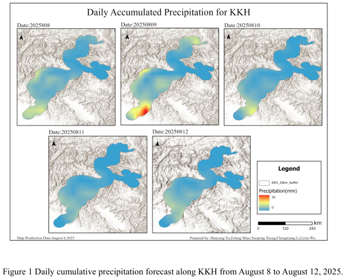
Combined with the precipitation forecast based on the NCFP GFS model on August 8, 2025 and multi-source data such as lithology, DEM and hydrological conditions along the Karakoram Highway, the TRIGRS model was adopted to conduct the landslide risk assessment in the northern area that was greatly affected by rainfall. The NCEP GFS precipitation forecast shows that on August 8th, the overall ...
DetailsCopyright © 2025. DRS4BR All rights reserved.