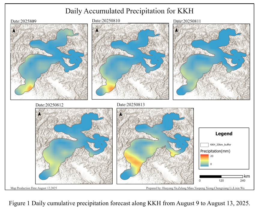
Combined with the precipitation forecast based on the NCFP GFS model onAugust 12, 2025, and multi-source data such as lithology, DEM, and hydrological conditions along the Karakoram Highway, the TRIGRS model was adopted to conduct landslide risk assessment in the northern area that was greatly affected by rainfall. The NCEP GFS precipitation forecast shows that on August 12, the overall rainfall along the Karakoram Highway decreased, primarily in the central to southern sections of the route, with a peak value of 9 mm.
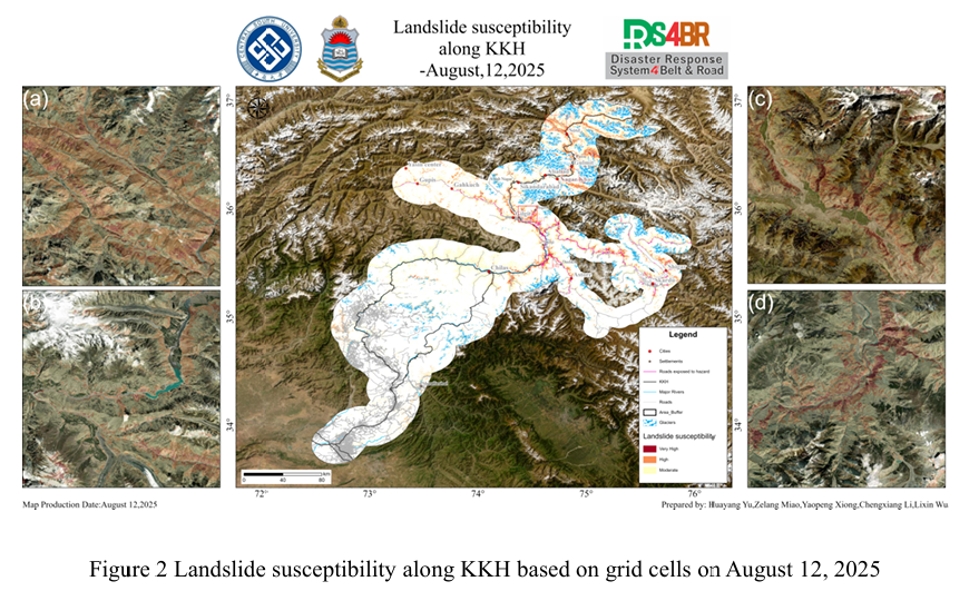
The assessment results (Figure 2) show that with the weakening of rainfall, the extent of extremely high-susceptibility zones along the Karakoram corridor has decreased. The extremely high and highly prone areas are mainly distributed in a band-like pattern along the main river valley corridors in the north, concentrated in mountainous areas with significant terrain undulations and deep rivers, especially in the sections around Chilas, Dashkin, Gilgit and north of Gulmit. These areas generally have steep slopes and high-density steep slopes, and the foot of the slope is close to major rivers and transportation arteries. Locally, they form clusters of high-risk values for landslides, constituting the core area of the landslide risk pattern in the northern region. In contrast, the overall landslide susceptibility in the south is still mainly of medium grade, with scattered spatial distribution and a patchy pattern. This difference may be related to the extensive glacier coverage in the area south of Chilas. The lagging response of glaciers to rainfall runoff and their impact on surface stability may, to a certain extent, suppress the rapid and concentrated manifestation of landslide risks. Moreover, the terrain in the southern region is relatively flat, and the topography has a significant impact on the susceptibility level of landslides.
Overall, the rainfall on August 12 showed a general decrease. The rainfall in the southern region was slightly greater than that in the northern region. However, the areas with more rainfall had relatively flat terrain, which had a smaller impact on the susceptibility. The spatial range of the extremely high and highly susceptible areas in the southern region did not show significant expansion and maintained a relatively stable spatial distribution. The northern region was controlled by complex terrain and a dense river valley network. The distribution of high-risk areas for landslides remains relatively stable and covers a large area, with a slight increase in coverage.
A further susceptibility analysis of the Gilgit–Skardu route indicates that the section from Gilgit to Skardu encompasses a large area of high-susceptibility zones, resulting in a relatively long affected road segment. The impact is particularly pronounced along the northern glacier belt, with a total affected length of 128.98 km. In contrast, the Astore–Minimarg route, located south of the Gilgit–Skardu corridor, is less affected. Owing to its relatively gentle terrain in the eastern section, the susceptible segments are mainly concentrated near the end connecting to the Karakoram Highway, totaling 43.17 km. In the vicinity of Skardu, steep terrain and concentrated cumulative rainfall markedly increase the risk of landslides, underscoring the need for strengthened monitoring and preventive measures.
The Gilgit–Chitral route, located to the west of the Karakoram Highway (KKH), has experienced temporary closures since June due to flooding triggered by persistent heavy monsoon rainfall. In the landslide susceptibility results of August 12, high-risk zones are concentrated along the Gahkuch–Gilgit section, with a total affected length of 19.06 km.
From the susceptibility results, it can be seen that the areas with high susceptibility along the Karakoram Highway are mainly distributed in the northern region, while the high-susceptibility areas in the south are relatively small and stable. The sections along the KKH such as the Chilas-Gilgit section and the section north of Gulmit, which are highly prone to landslides, should be regarded as key risk areas. Special attention should be paid to the defense against landslides in the northern region, as well as the occurrence of high and steep slopes and mudslides during and after rainfall.
结合 2025 年 8月 12日基于 NCFPGFS 模式的降水预报与喀喇昆仑公路沿线的岩性、DEM、水文条件等多源数据,采用TRIGRS模型,对受降雨影响较大的北部地区展开滑坡危险性评估。NCEPGFS降水预报显示,8 月 12日,喀喇昆仑公路沿线整体降雨量有所下降,主要基于中沿线南部区域,峰值为9mm。
评估结果表明(图2),随着降雨的减弱,喀喇昆仑沿线极高易发区范围有所缩小。极高及高易发区主要沿北部主要河谷走廊呈带状分布,集中出现在地形起伏显著、河流深切的山地地带,尤以 Chilas、Dashkin、Gilgit 周边及 Gulmit 以北路段最为典型。这些区域普遍存在陡峭坡面、高密度陡坡,且坡脚邻近主要河流与交通干线,局部形成滑坡高风险值的聚集区,构成了北部地区滑坡风险格局的核心区域。相较之下,南部整体滑坡易发性仍以中等易发等级为主,空间分布零散,呈现斑块状格局。此差异可能与 Chilas 以南地区广泛分布的冰川覆盖有关,冰川对降雨径流的滞后响应及其对地表稳定性的影响可能在一定程度上抑制了滑坡风险的快速集中表现。且南部地区地形较为平坦,地势对于滑坡易发性的等级影响较大。
总体而言,8月12日降雨量总体降低,南部区域降雨比北部区域降雨量稍大,但降雨量较大地区地势较为平坦,对于易发性的影响较小,南部区域的极高及高易发区的空间范围未出现明显扩展,且保持比较稳定的空间分布,北部地区受控于复杂地形与密集河谷网络,滑坡高易发区分布仍保持相对稳定,并且范围较大,覆盖范围有小幅度的提升。
对Gilgit-Skardu 线路进行进一步的易发性分析,由于从Gilgit到Skardu地区路段的高易发性区域面积较大,因此受影响的公路路段线路也比较长,沿着北侧冰川一带滑坡风险较为显著,受影响线路总长为128.98km;位于Gilgit-Skardu线路南侧的Astore-Minimarg 线路受影响较小,其地势在线路东部较为平缓,受影响路段主要集中于靠近KKH一端,总长度为43.17km。在 Skardu 附近,受地形陡峭和累积降雨集中影响,滑坡风险显著增加,需加强监测与防范措施。
位于KKH西侧的Gilgit-Chitral 线路,自6月以来,受持续的强季风降雨引发的洪水影响,该线路出现一段时间的封闭。在8月12日的滑坡易发性结果中,Gahkuch至Gilgit路段滑坡高风险区域较为集中,受影响线路总长度19.06km。
从易发性结果可以看出,喀喇昆仑公路沿线易发性高的区域主要分布于北部地区,南部高易发区范围较小且比较稳定。沿 KKH 穿越的Chilas-Gilgit路段 、Gulmit以北段等高易发性路段应被视为重点风险区段,需重点关注北部地区滑坡的防御工作,以及在降雨过程中与雨后的高陡切坡、泥石流等灾害。