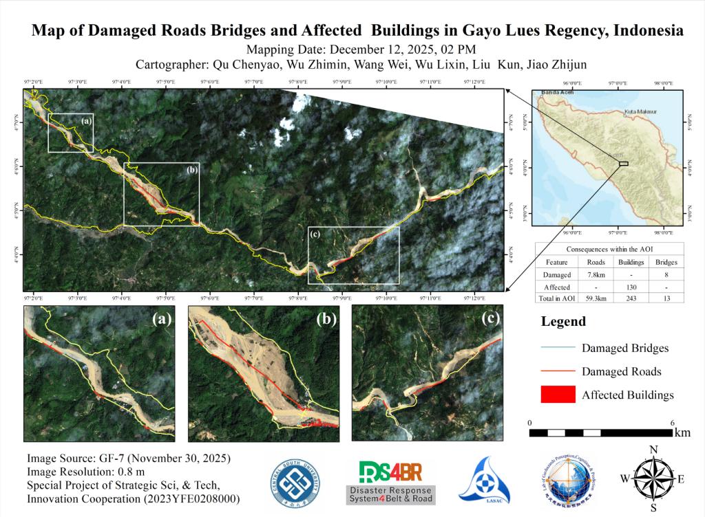
Following continuous heavy rainfall starting on November 22, 2025, flooding occurred in Gayo Lues Regency, Indonesia (approximately 4.067°–4.133° N, 97.025°–97.217° E). Based on remote sensing data acquired by the Gaofen-7 (GF-7) satellite on November 30, a preliminary assessment was conducted by overlaying flood inundation extents with building and road data, combined with manual visual inte...
Details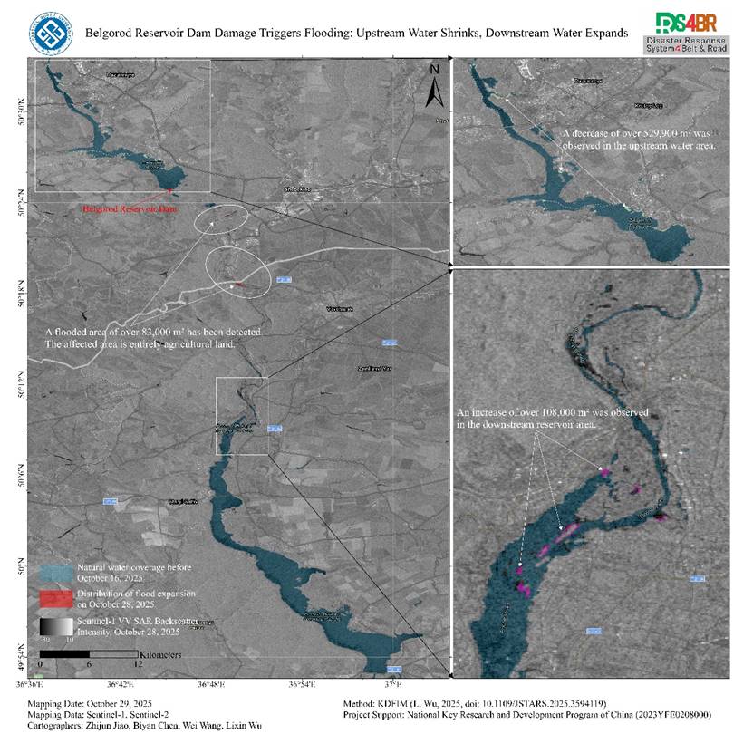
Under the leadership of Professor Lixin Wu, Academician of the International Eurasian Academy of Sciences and head of the Remote Sensing Discipline at Central South University, his research team utilized the Disaster Response System for the Belt and Road (DRS4BR). Based on the Knowledge-Driven Flood Intelligent Monitoring (KDFIM) module within this system and using Sentinel-1 and Sentinel-2 sat...
Details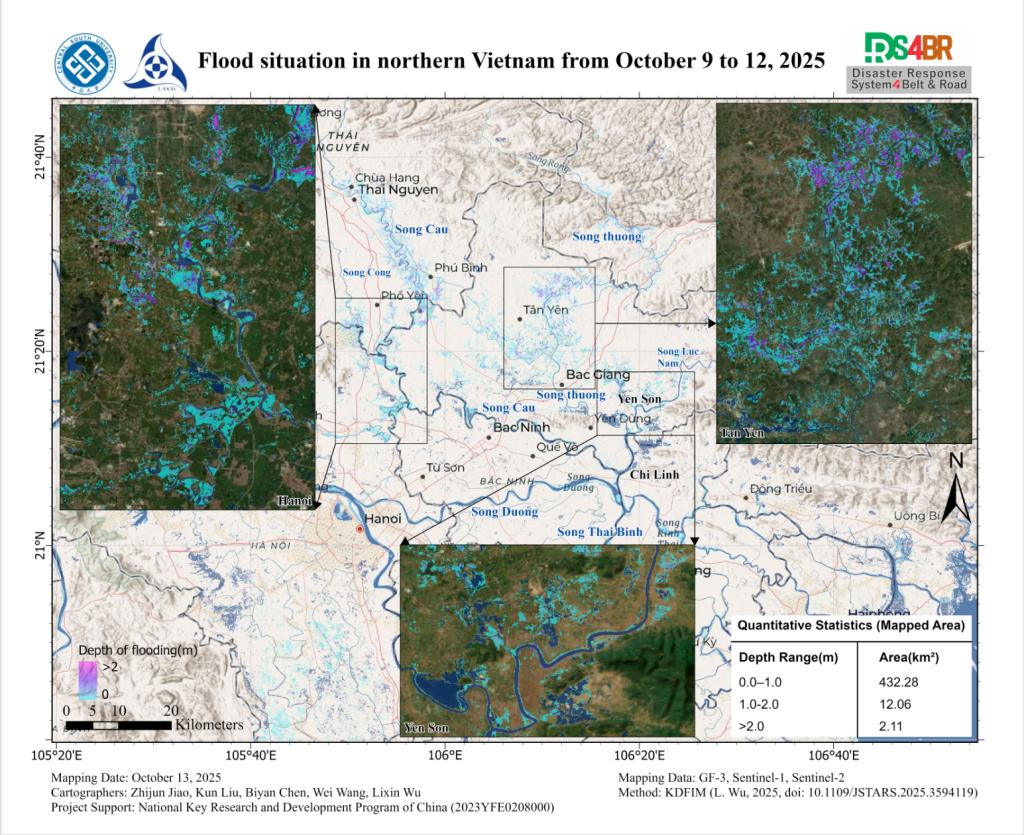
In northern Vietnam, under the combined influence of the residual circulation of Typhoon Matmo and orographic uplift, rainfall was intense and spatially concentrated. The core precipitation zones were mainly distributed in the Sông Cầu and Sông Thương basins and their tributaries, including the Sông Công and Sông Lục Nam. In mountainous and hilly regions, cumulative rainfall generally excee...
Details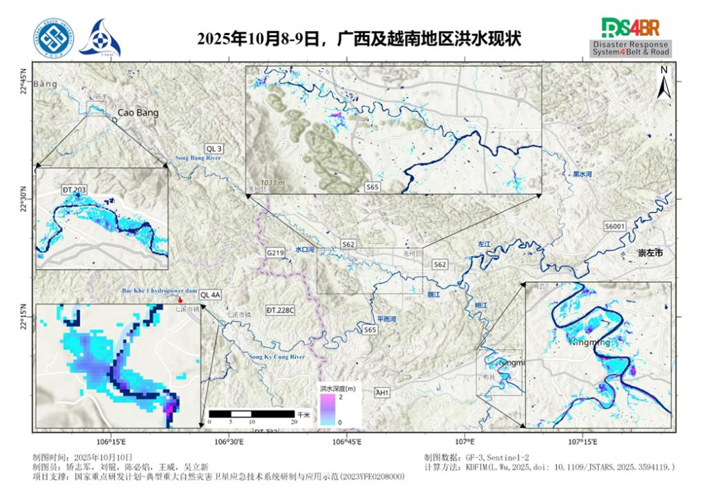
据央视新闻报道,2025年10月以来,第21号台风“麦德姆”及其残余环流持续影响广西西部及越南北部,多地出现历史罕见强降雨。广西左江、明江、黑水河等主要江河水位暴涨,沿岸低洼地区出现内涝,农田、交通设施受损严重。中南大学遥感学科带头人、国际欧亚科学院士吴立新教授团队,依托其主导的一带一路减灾服务系统(DRS4BR),基于其中的知识驱动洪水智能监测算法(KDFIM)模块,联合我国高分三号卫星影像与公开的Sentinel-2卫星影...
Details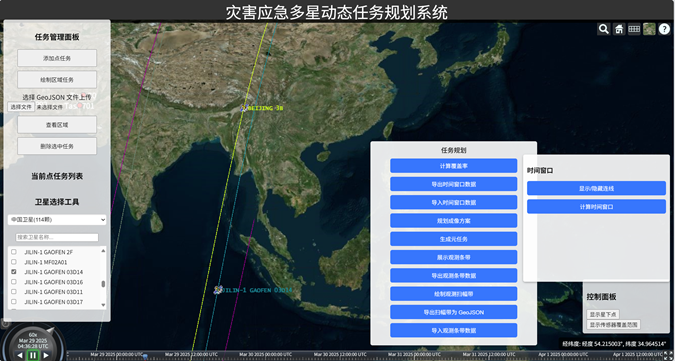
Topic 2, Subtopic 1, studies the disaster emergency satellite mission planning subsystem, as shown in Figure 1.Figure 1. Interface of the Disaster Emergency Multi-Satellite Dynamic Task Planning SystemAt 14:20 on March 28, 2025, a magnitude 7.9 earthquake occurred in central Myanmar. After the project team initiated the emergency response, seismic parameters such as PGA released by the USGS wer...
Details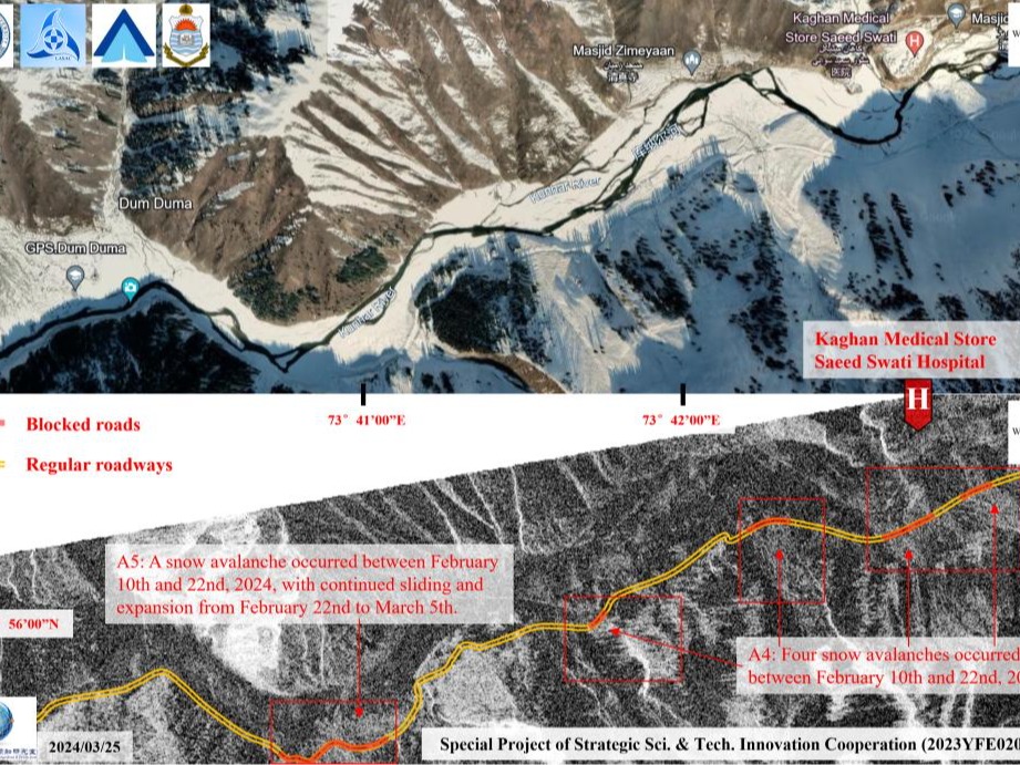
The avalanche incident occurred in Naran, northern Pakistan on March 21, 2024, which submerged houses and hotels, served as a trigger for further in-depth analysis of avalanche risks in the downstream towns and villages. Through comprehensive multi-case studies, it was found that the phenomenon of snow melting into water before heavy precipitation warrants particular vigilance, as it greatly in...
Details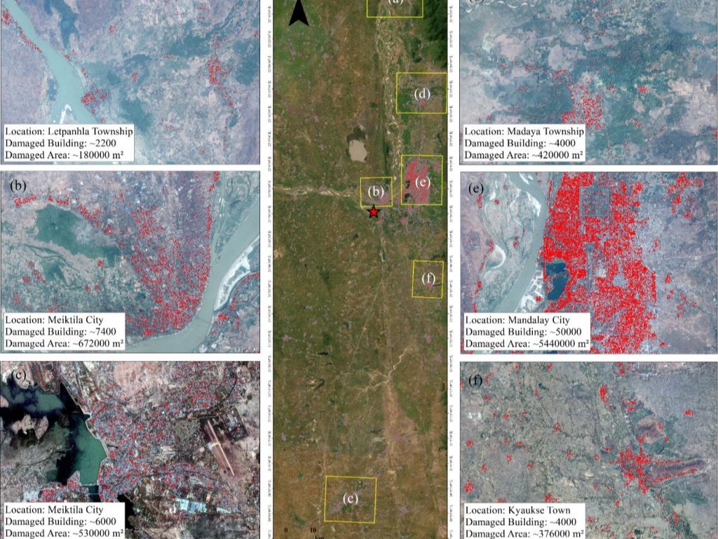
Leveraging GF-1B high-resolution satellite imagery (2-meter resolution) provided by the Land Satellite Remote Sensing ApplicationCenter,Ministry of Natural Resources of China, our team conducted a comprehensive damage assessment of buildings impacted by the March 28 Myanmar earthquake. The data revealed severe structural losses, with Mandalay Citysufferingthe most extensive damage—50,000 build...
Details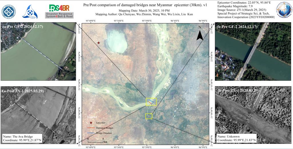
Utilizing ZY-1 high-resolution imagery (2- meter resolution) provided by the Land Satellite Remote Sensing Application Center, Ministry of Natural Resources of China, combined with advanced deep learning-based small target recognition algorithms, our team automated damage detection across bridge networks. Partial collapse of a kilometer-scale bridge (The Ava Bridge, coordinates 21.87° N, 95.99°...
Details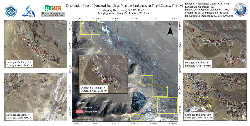
According to the China Earthquake Networks Center, at 09:05 on January 7, 2025, an M6.8 earthquake occurred in Dingri County, Shigatse City, Tibet Autonomous Region. The focal depth was 10 kilometers, and the epicenter was located at 28.50 degrees north latitude and 87.45 degrees east longitude. On January 9, the joint scientific research team of Central South University and the National Satell...
DetailsCopyright © 2025. DRS4BR All rights reserved.