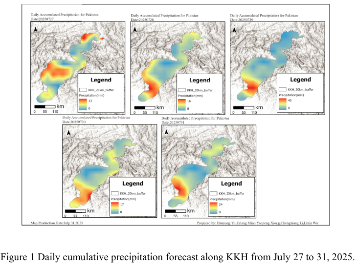
Combined with the precipitation forecast based on the NCFP GFS model on July 31, 2025 and multi-source data such as lithology, DEM and hydrological conditions along the Karakoram Highway, the TRIGRS model was adopted to conduct the landslide risk assessment in the northern area that was greatly affected by rainfall. The NCEP GFS precipitation forecast indicates that on July 31st, the rainfa...
Details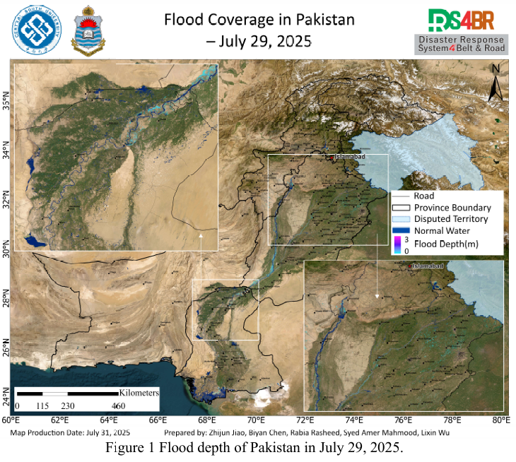
Based on multi-source remote sensing data acquired between July 16 and 30, 2025, including Sentinel-1, Sentinel-2, Landsat-8, and Landsat-9, combined with the KDFIMv2 algorithm, a dynamic monitoring and comprehensive assessment of flood inundation extent and water depth across Pakistan has been conducted.Fig. 1 illustrates the spatial distribution of flood water depth on July 29, 2025. The ...
Details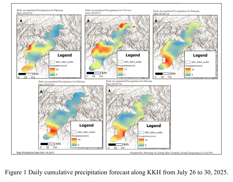
Combined with the precipitation forecast based on the NCFP GFS model on July 29, 2025 and multi-source data such as lithology, DEM and hydrological conditions along the Karakoram Highway, the TRIGRS model was adopted to conduct the landslide risk assessment in the northern area that was greatly affected by rainfall. The NCEP GFS precipitation forecast shows that the rainfall along the Karak...
Details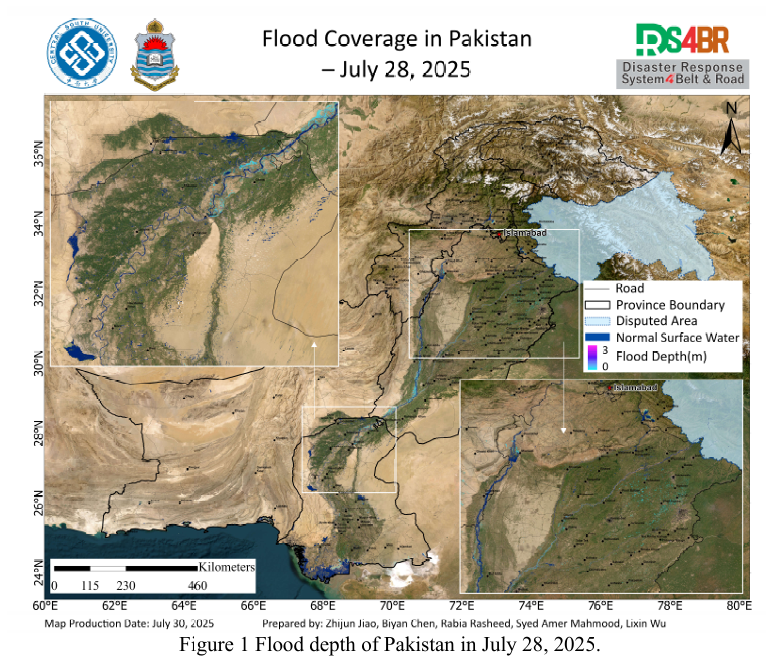
Based on multi-source remote sensing data acquired between July 16 and 29, 2025, including Sentinel-1, Sentinel-2, Landsat-8, and Landsat-9, combined with the KDFIMv2 algorithm, a dynamic monitoring and comprehensive assessment of flood inundation extent and water depth was conducted across Pakistan.Fig. 1 illustrates the spatial distribution of flood water depth on July 28, 2025. The analy...
Details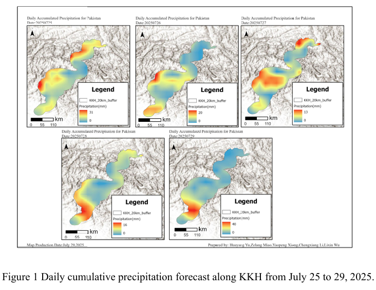
Combined with the precipitation forecast based on the NCFP GFS model on July 29, 2025 and multi-source data such as lithology, DEM and hydrological conditions along the Karakoram Highway, the TRIGRS model was adopted to conduct the landslide risk assessment in the northern area that was greatly affected by rainfall. The NCEP GFS precipitation forecast shows that the rainfall along the Karak...
Details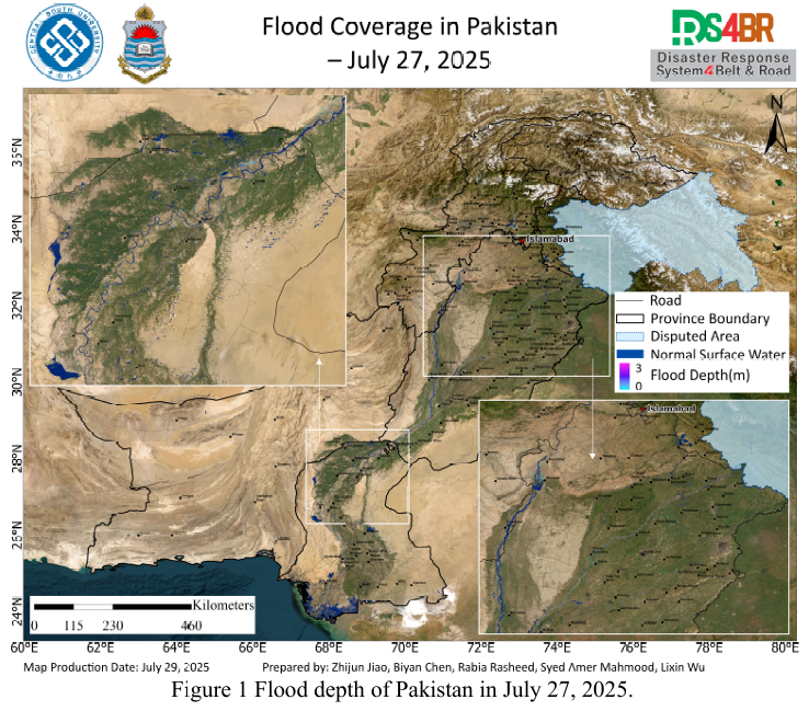
Based on multi-source remote sensing data acquired from July 16 to 28, 2025, including Sentinel-1, Sentinel-2, Landsat-8, and Landsat-9, a dynamic flood monitoring and comprehensive assessment was conducted across Pakistan using the KDFIMv2.Fig. 1 presents the spatial distribution of floodwater depth on July 27, 2025. The results indicate that the flood situation has significantly abated, with ...
Details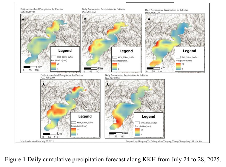
Combined with the precipitation forecast based on the NCFP GFS model on July 28, 2025 and multi-source data such as lithology, DEM and hydrological conditions along the Karakoram Highway, the TRIGRS model was adopted to conduct the landslide risk assessment in the northern area that was greatly affected by rainfall. The NCEP GFS precipitation forecast shows that on July 28th, there will be ...
Details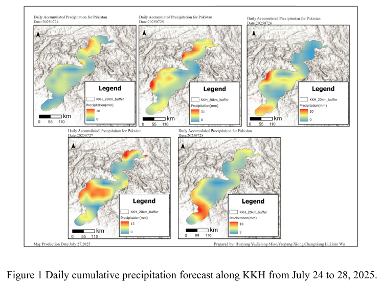
Combined with the precipitation forecast based on the NCFP GFS model on July 27, 2025 and multi-source data such as lithology, DEM and hydrological conditions along the Karakoram Highway, the TRIGRS model was adopted to conduct the landslide risk assessment in the northern area which is greatly affected by rainfall. NCEP GFS precipitation forecast shows that there will be less rainfall alon...
Details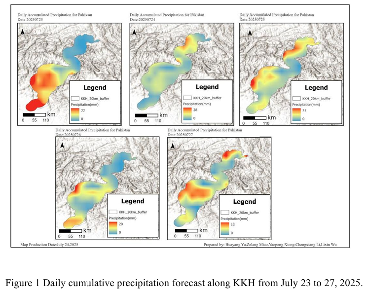
Combined with the precipitation forecast based on the NCFP GFS model on July 26, 2025 and multi-source data such as lithology, DEM and hydrological conditions along the Karakoram Highway, the TRIGRS model was adopted to conduct the landslide risk assessment in the northern area which is greatly affected by rainfall. The NCEP GFS precipitation forecast shows that the national rainfall will d...
Details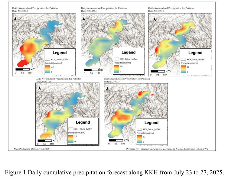
Combined with the precipitation forecast based on the NCFP GFS model on July 25, 2025 and multi-source data such as lithology, DEM and hydrological conditions along the Karakoram Highway, the TRIGRS model was adopted to conduct the landslide risk assessment in the northern area which is greatly affected by rainfall. The precipitation forecast of NCEP GFS shows that from Gilgit to Khyber in...
Details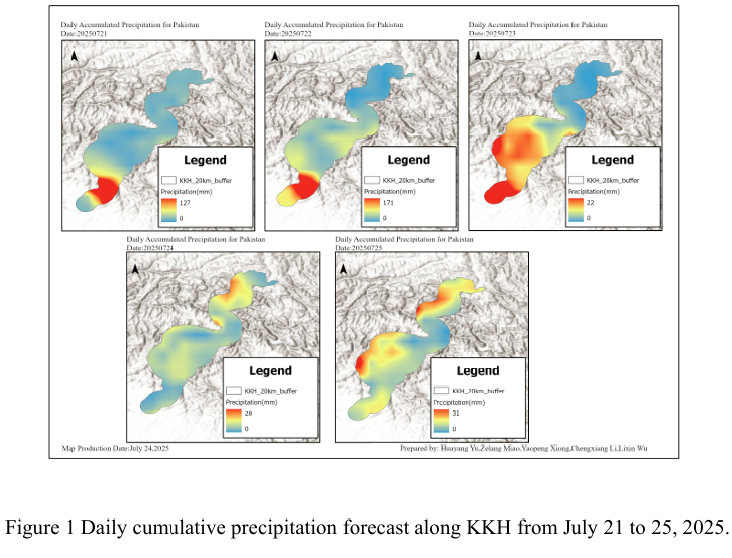
Combined with the precipitation forecast based on the NCFP GFS model on July 24, 2025 and multi-source data such as lithology, DEM and hydrological conditions along the Karakoram Highway, the TRIGRS model was adopted to conduct the landslide risk assessment in the northern area which is greatly affected by rainfall. The NCEP GFS precipitation forecast indicates that on July 24th, there will be ...
Details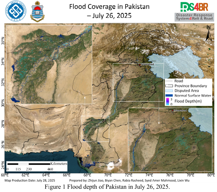
Based on multi-source remote sensing data acquired from July 16 to 27, 2025, including Sentinel-1, Sentinel-2, Landsat-8, and Landsat-9, the flood extent and water depth across Pakistan were dynamically monitored and comprehensively assessed using the KDFIMv2 algorithm.Fig. 1 illustrates the spatial distribution of floodwater depth on July 26, 2025. The results indicate a general recession tren...
Details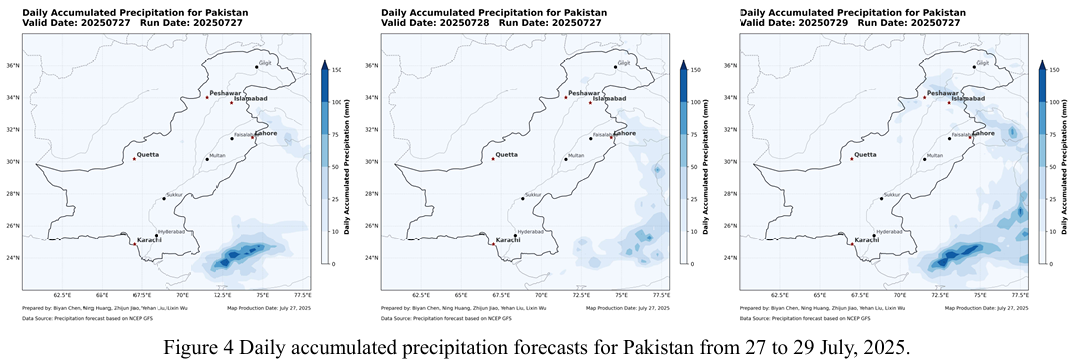
Based on multi-source remote sensing data acquired on July 25–26, 2025 from Sentinel-1, Sentinel-2, Landsat-8, and Landsat-9, the KDFIMv2 algorithm was employed to perform the latest dynamic monitoring and integrated assessment of flood inundation extent and water depth across Pakistan.Fig.1 presents flood water depth estimates for July 25, 2025. The monitoring results indicate a gradual reduc...
Details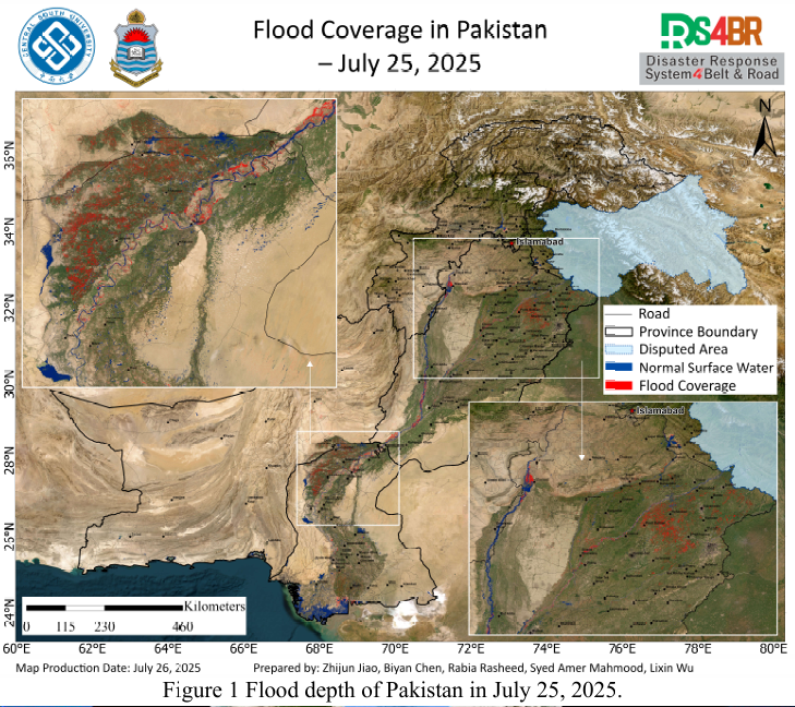
Figure 2 Cloud distribution observed by FY-4B at 3:00 and 10:00 UTC on July 26, 2025.Based on multi-source remote sensing data acquired on July 25, 2025—including Sentinel-1, Sentinel-2, Landsat-8, and Landsat-9—the latest flood inundation extent across Pakistan was dynamically monitored and comprehensively assessed using the KDFIMv2 algorithm (Fig. 1). In parallel, FY-4B geostationary met...
Details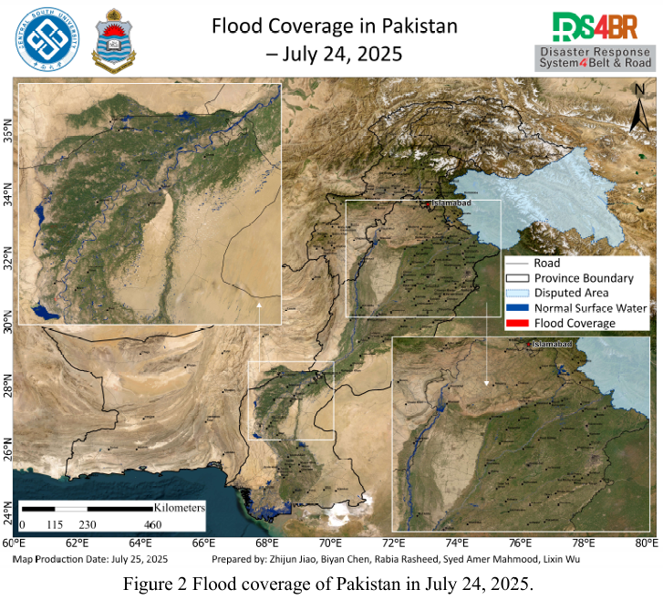
Based on multi-source remote sensing data from Sentinel-1, Sentinel-2, Landsat 8, and Landsat-9 acquired between July 23 and 24, 2025, flood depth (Fig.1) and inundation extent (Fig.2) across Pakistan were dynamically monitored and comprehensively assessed using the KDFIMv2 algorithm. Additionally, meteorological conditions and potential secondary disaster risks were analyzed using FY-4B geosta...
Details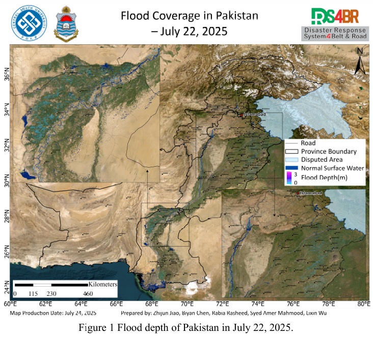
Based on multi-source optical and radar remote sensing imagery from Sentinel-1, Sentinel-2, Landsat-8, and Landsat-9 acquired between July 22 and 23, 2025, and processed using the KDFIMv2 algorithm, a dynamic assessment and integrated analysis of flood depth (Fig. 1) and inundation extent (Fig. 2) across Pakistan has been conducted. Meteorological changes and future disaster risks were further ...
Details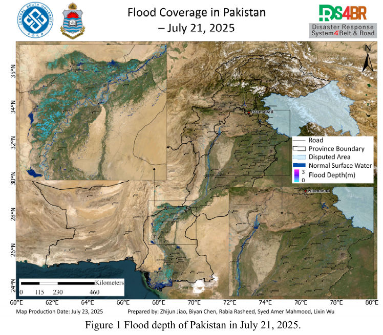
Based on the optical and radar remote sensing imagery from Sentinel-1, Sentinel 2, Landsat-8, and Landsat-9 acquired between July 21 and 22, 2025, floodwater depth (Fig. 1) and inundation extent (Fig. 2) across Pakistan were dynamically evaluated and comprehensively analyzed using the KDFIMv2 algorithm. Relevant meteorological changes and future risk trends were assessed based on FY-4B geostati...
Details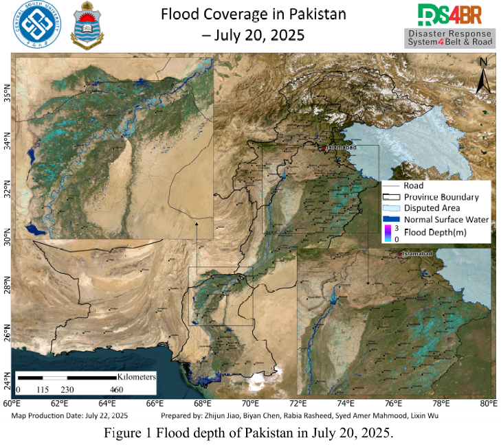
Based on remote sensing monitoring results from July 20 to 21, 2025, a comprehensive analysis and dynamic assessment of flood water depth (Fig. 1) and inundation extent (Fig. 2) across Pakistan was conducted. This analysis utilized multi source optical and radar satellite imagery from Sentinel-1, Sentinel-2, Landsat-8, and Landsat-9, in combination with the KDFIMv2 algorithm.The flood water dep...
Details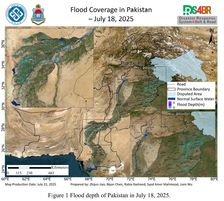
Based on remote sensing observations from July 18 to 20, 2025, a comprehensive flood assessment was conducted over Pakistan by integrating multi-source satellite imagery from Sentinel-1, Sentinel-2, Landsat-8, and Landsat-9, and applying the KDFIMv2 algorithm for enhanced spatial flood analysis. The assessment focused on flood water depth (Fig. 1) and inundation extent (Fig. 2).The flood water ...
Details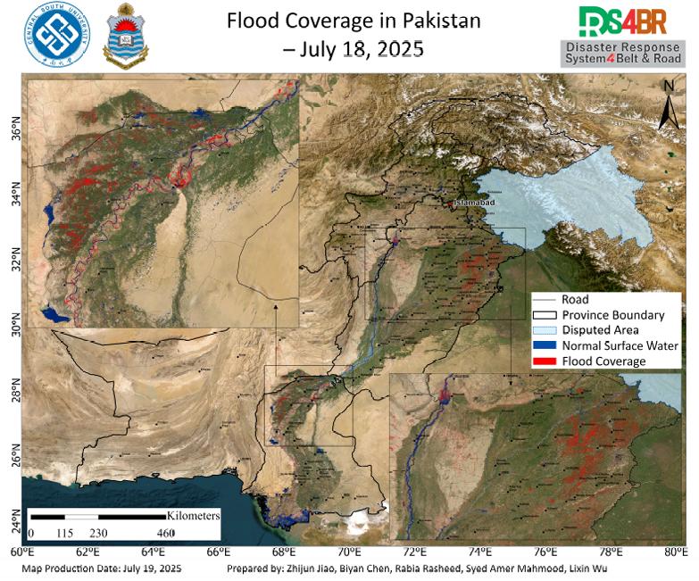
According to the remote sensing monitoring results from July 18, 2025, a comprehensive assessment of flood inundation across Pakistan was conducted using multi-source satellite imagery from Sentinel-1, Sentinel-2, Landsat-8, and Landsat-9 (Fig. 1). The results indicate that flood-affected areas have continued to expand, with significant inundation observed across the Indus River Basin and surro...
DetailsCopyright © 2025. DRS4BR All rights reserved.