
Based on multi-source remote sensing data from Sentinel-1, Sentinel-2, Landsat 8, and Landsat-9 acquired between July 23 and 24, 2025, flood depth (Fig.1) and inundation extent (Fig.2) across Pakistan were dynamically monitored and comprehensively assessed using the KDFIMv2 algorithm. Additionally, meteorological conditions and potential secondary disaster risks were analyzed using FY-4B geostationary satellite cloud imagery (Fig.3) and NCFP GFS global precipitation forecast data (Fig.4).
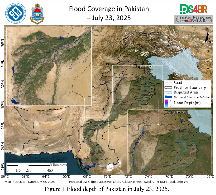
Fig.1 illustrates the flood water depth distribution on July 23, 2025. Remote sensing analysis indicates that most areas in Sindh Province experienced rapid drainage, with residual water confined to localized lowlands. In contrast, large-scale inundation persists in Punjab Province, with water depths around 1 meter in some areas. Around the Chashma Reservoir and along the main course of the Indus River, the flood extent remains relatively stable, though certain sections exhibit deeper water—up to approximately 3 meters—posing potential risks to embankments and reservoir management.
Fig.2 shows the flood inundation extent on July 24, 2025. Due to limited satellite coverage, observations are mainly concentrated in western Sindh. Results show a significant reduction in water coverage compared to the previous day, with only scattered standing water in some agricultural fields, indicating a clear recession trend.
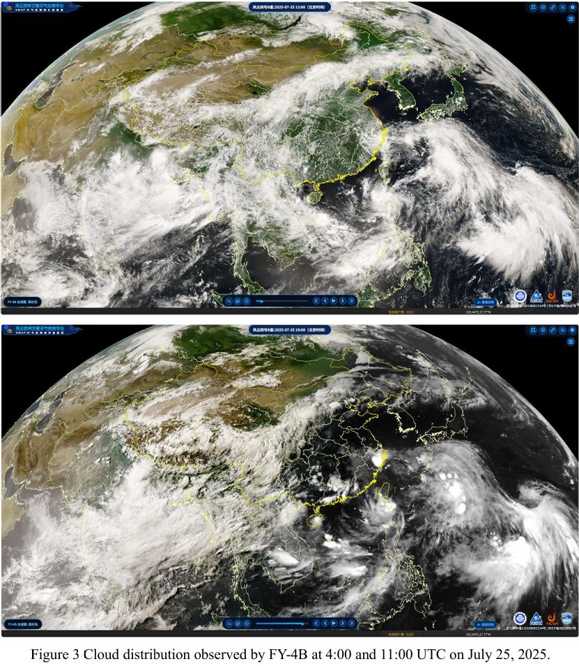
Fig.3 presents cloud coverage captured by the FY-4B satellite on July 25. As of 11:00 UTC, most regions across Pakistan were under clear skies, with cloud presence primarily over parts of Sindh and the mountainous regions of Gilgit-Baltistan (GB) and Khyber Pakhtunkhwa (KP). Heavy cloud cover was mainly confined to the northern highlands.
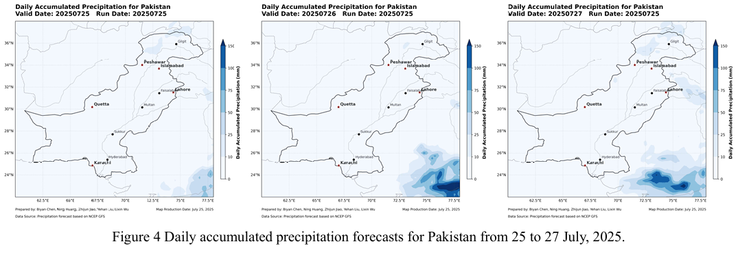
Fig.4 shows precipitation forecasts from the NCFP GFS model for July 25–26. Apart from minor rainfall expected in northern KP and GB, no significant precipitation is forecasted for the rest of the country. This favorable weather window presents a critical opportunity for flood relief efforts and post-disaster recovery operations.
根据2025 年7月23日至24日获取的Sentinel-1、Sentinel-2、Landsat-8 与Landsat-9 等多源遥感数据,采用 KDFIMv2 算法对巴基斯坦境内的洪水水深(Fig.1)与淹没范围(Fig.2)进行了最新动态监测与综合评估。同时,结合FY 4B 静止气象卫星云图(Fig.3)与NCFP GFS全球降水预报模型(Fig.4),研判未来区域气象变化及次生灾害风险。
Fig.1 显示2025 年7月23日的洪水水深情况。遥感结果表明,信德省大部分区域积水已快速退去,仅局部低洼地存在残留水体;而旁遮普省大面积积水仍在持续,部分区域水深维持在约1米左右。Chashma水库周边及印度河主干道沿 线洪水范围基本稳定,但部分地段水深较大,局部达到约3米,需重点关注堤防安全与水库调度压力。
Fig.2 为 2025 年7月24日的洪水淹没范围分布。受限于当日观测数据,主要覆盖信德省西部区域。结果显示,信德省积水范围较23日明显缩减,仅有少数农田仍有零星积水,整体退水趋势显著。
Fig.3 为 FY-4B卫星于7月25日获取的云图。UTC时间11时数据显示,巴基斯坦大部地区天气晴朗,仅信德省局部及北部吉尔吉特-巴尔蒂斯坦(GB)与开伯尔-普赫图赫瓦省(KP)山区出现一定云层覆盖,其中北部山区云量较重。
Fig.4 基于NCFP GFS模型的未来降水预报显示,7月25日至26日期间, 除KP和GB北部山区可能出现小幅降水外,巴基斯坦其余大部地区无明显降水过程。短期内天气形势有利,为洪涝救援与灾后恢复工作提供了关键窗口期。