


根据2025年7月16日至8月1日期间获取的Sentinel-1、Sentinel-2、Landsat-8、Landsat-9等多源遥感数据,结合KDFIMv2洪水反演算法,对巴基斯坦境内的洪水淹没范围与水深情况开展了动态监测与综合评估。
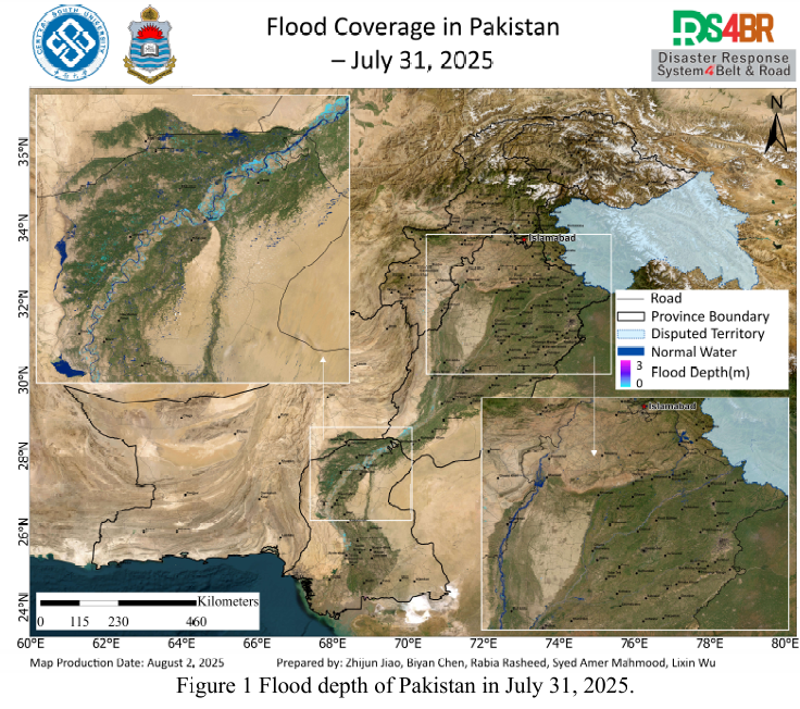
图1展示了2025年7月31日的洪水水深空间分布图。结果显示,无论是洪水淹没范围还是水深情况均已显著减少,洪水整体处于明显退去阶段,仅在印度河流域部分区域存在季节性涨水现象,主要集中在河道内。
图2为2025年8月1日的洪水淹没范围图,进一步验证了洪水消退的趋势。虽然遥感数据覆盖范围主要集中在巴基斯坦中部地区,但整体淹没区域已大幅缩减,地表积水现象明显减少。
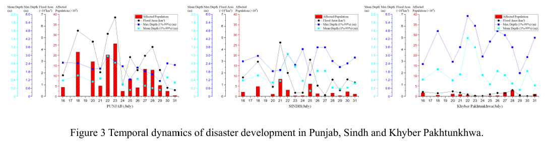
图3反映了自7月16日以来旁遮普省、信德省与开伯尔-普赫图赫瓦省(KP)等主要受灾区域的洪涝演变过程。统计结果显示,平均水深和淹没范围持续下降,当前已接近历史低覆盖的平稳期,洪涝影响显著减弱,有利于灾后恢复及农田排涝作业的推进。
尽管洪水总体趋于缓解,图4(FY-4B静止气象卫星云图)显示,今日13时,巴基斯坦中部地区出现大范围卷云覆盖,预示夜间可能出现降水过程,需关注局地天气变化。
根据图5所示的NCFP GFS全球降水预报模型预测,未来两天巴基斯坦北部山区仍存在一定的降水概率,特别是KP省及伊斯兰堡周边区域,局部可能出现50mm以上降水。需警惕山洪、滑坡等次生地质灾害的风险。
From July 16 to August 1, 2025, multi-source remote sensing data including Sentinel-1, Sentinel-2, Landsat-8, and Landsat-9 were used in conjunction with the KDFIMv2 flood inversion algorithm to conduct dynamic monitoring and comprehensive assessment of flood inundation extent and water depth across Pakistan.
Fig. 1 illustrates the spatial distribution of flood water depth on July 31, 2025. The results indicate a significant reduction in both flood extent and water depth, suggesting that the flood has largely receded. Only seasonal water level rises remain along portions of the Indus River, mainly confined within the main channel.
Fig. 2 shows the flood inundation extent on August 1, 2025, further confirming the recession trend. Although satellite coverage mainly includes central Pakistan, flood coverage is now minimal, with very limited surface water detected.
Fig. 3 presents the temporal evolution of flooding in major affected regions including Punjab, Sindh, and Khyber Pakhtunkhwa (KP) since July 16. Statistical analysis indicates that both average water depth and inundated area have steadily declined, approaching a historically low and stable phase. This decline facilitates post-disaster recovery and farmland drainage operations.
Despite the overall recession of the flood, Fig. 4 (FY-4B geostationary satellite imagery) shows widespread cirrus clouds over central Pakistan at 13:00 local time, suggesting potential nighttime precipitation. Localized weather developments should be closely monitored.
According to Fig. 5, the NCFP GFS global precipitation forecast model indicates continued rainfall potential over the northern mountainous areas in the next two days, particularly in KP Province and around Islamabad. Some areas may receive over 50 mm of rainfall, posing risks of flash floods, landslides, and other secondary geological hazards.