Based on multi-source remote sensing data acquired from July 16 to 28, 2025, including Sentinel-1, Sentinel-2, Landsat-8, and Landsat-9, a dynamic flood monitoring and comprehensive assessment was conducted across Pakistan using the KDFIMv2.
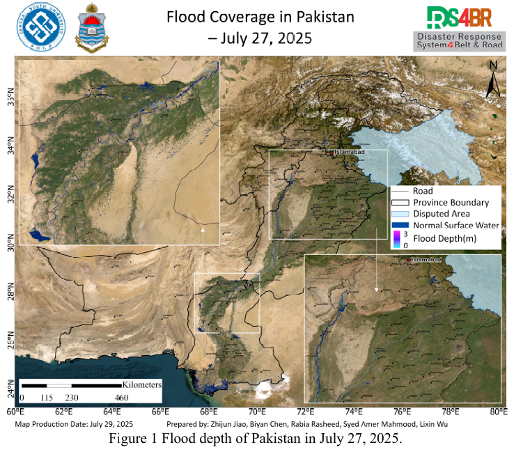
Fig. 1 presents the spatial distribution of floodwater depth on July 27, 2025. The results indicate that the flood situation has significantly abated, with most inundated areas showing an average water depth of approximately 0.5 meters. Floodwaters were primarily confined to areas adjacent to river basins. Waterlogging in farmlands is receding, and the surface extent of seasonal rivers and reservoirs has stabilized.
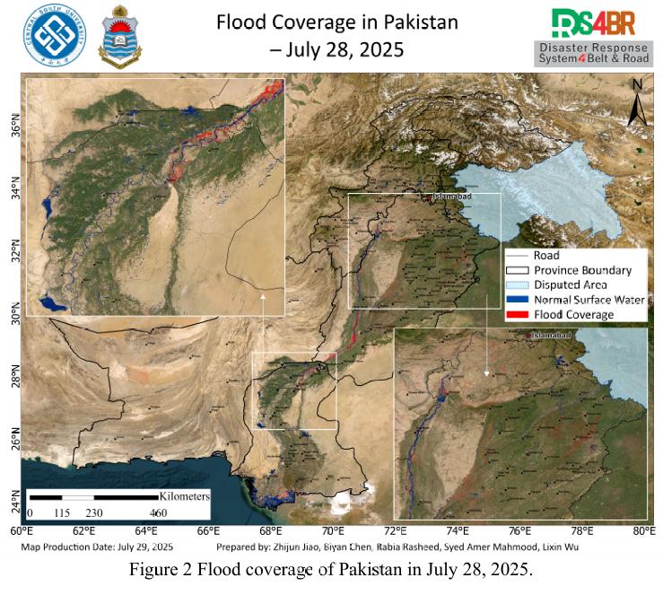
Fig. 2 shows the flood inundation extent on July 28. The flooded area further contracted, remaining concentrated around river catchments and low-lying basins. Seasonal streams and some reservoir zones still retained residual water. Farmlands in parts of Punjab Province continued to be affected by surface flooding.
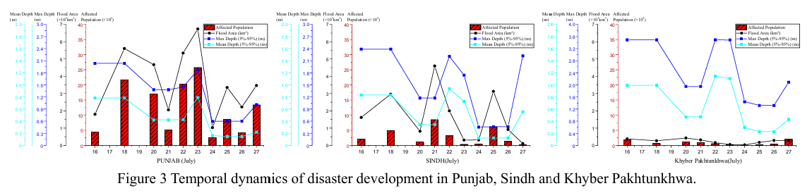
Fig. 3 illustrates the spatiotemporal evolution of flood conditions in Punjab, Sindh, and Khyber Pakhtunkhwa (KP) provinces since July 16, 2025. Remote sensing-based evaluation indicates a continuous recession trend in flood extent. Punjab Province exhibits a substantially larger inundated area and affected population compared to Sindh and KP. Most flooded regions exhibit shallow water depth (<0.5 m), although main channels of the Indus River and selected reservoirs still show depths exceeding several meters.
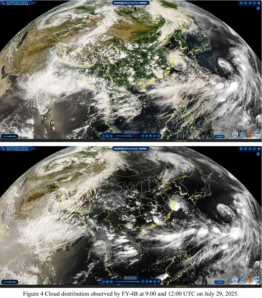
Fig. 4 displays convective cloud development observed by the FY-4B geostationary meteorological satellite at 09:00 UTC on July 29. The imagery reveals extensive convective cloud clusters forming over northern Punjab and mountainous KP, moving westward, implying heightened risk of short-term heavy precipitation and convective weather. Enhanced monitoring and early warning efforts are recommended.
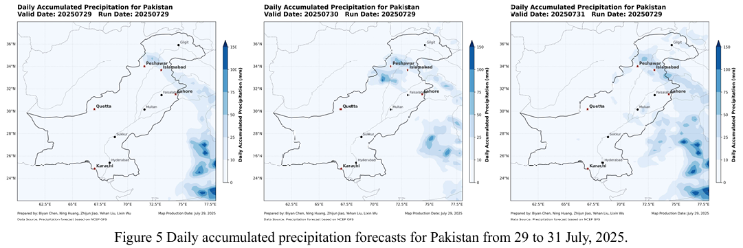
Fig. 5 presents the NCFP GFS global precipitation forecast. The model predicts a new precipitation episode over Punjab and KP provinces from July 29 to 30, with potential for moderate to heavy rainfall. Localized heavy downpours may trigger rapid runoff and increase the risk of secondary geological hazards in mountainous areas. Proactive flood response and mitigation planning are advised for the affected regions.
根据2025年7月16日至28日期间获取的Sentinel-1、Sentinel-2、Landsat 8 与Landsat-9 等多源遥感数据,采用KDFIMv2算法,对巴基斯坦境内的洪水淹没范围及水深开展动态监测与综合评估。
图1 显示了2025年7月27日的洪水水深空间分布。分析结果表明,洪水整体处于明显退水阶段,大多数区域水深已降至平均约0.5米,洪水主要集中于河流流域附近,农田积水正在逐步消退,季节性河道及水库水体面积趋于稳定。
图2 展示了7月28日的洪水淹没范围。淹没区域继续收缩,主要分布在流域及其周边地区,部分季节性河流和库区仍有残留积水现象。旁遮普省部分农业区域仍受洪水影响,局地淹没情况较为明显。
图3 表征了自2025年7月16日以来旁遮普省(Punjab)、信德省(Sindh) 与开伯尔-普赫图赫瓦省(Khyber Pakhtunkhwa, KP)的洪涝灾情演变过程。评估结果显示,洪水总体处于持续减退状态,其中旁遮普省的淹没面积和潜在受灾人 口显著高于信德省与KP省。绝大多数受淹区域水深低于0.5米,印度河干流及少数库区水深仍可达数米以上。
图4 为FY-4B静止轨道气象卫星于2025年7月29日9时(UTC)获取的云团演变监测图。遥感结果显示,旁遮普省北部与KP山区出现大范围强对流云团,并呈西移趋势,短时强降水和局地强对流天气风险上升,需引起重视。
图5 展示了NCFP GFS全球降水预报模型输出。结果预测2025年7月29日至30日期间,旁遮普省及KP山区将经历新一轮中到大雨过程,局地暴雨可能诱发山区径流增强及次生地质灾害风险,建议相关区域提前部署防汛减灾措施。