


Based on multi-source remote sensing data acquired between July 16 and 30, 2025, including Sentinel-1, Sentinel-2, Landsat-8, and Landsat-9, combined with the KDFIMv2 algorithm, a dynamic monitoring and comprehensive assessment of flood inundation extent and water depth across Pakistan has been conducted.
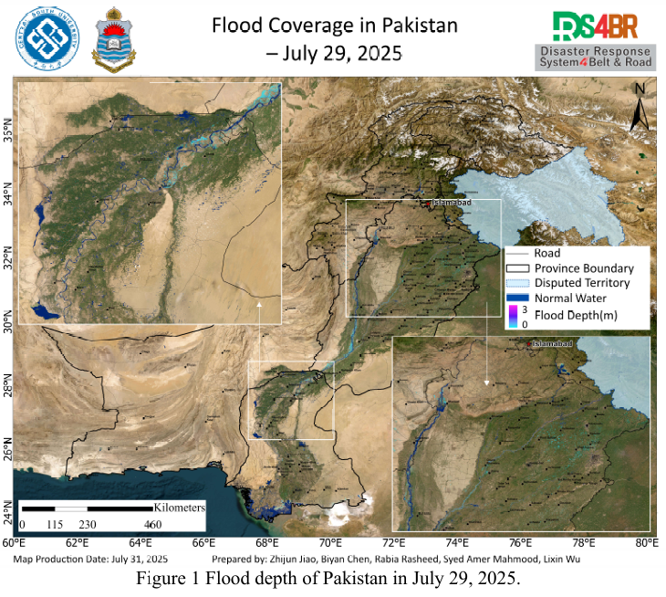
Fig. 1 illustrates the spatial distribution of flood water depth on July 29, 2025. The analysis indicates that the flood situation is steadily receding. The mean water depth across affected areas is below 0.5 meters, while water depth in main river channels and seasonal floodplains exceeds 1 meter. The extent of inundation has substantially reduced.
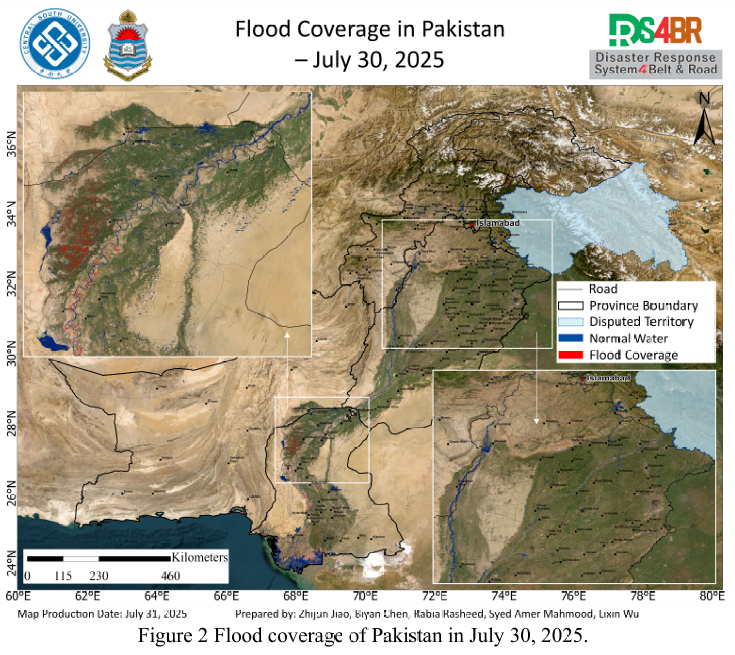
Fig. 2 presents the flood extent as of July 30, 2025, confirming the continued recession of floodwaters. Although residual water remains in some low-lying agricultural areas and floodplains, the overall inundated area has significantly decreased.
Fig. 3 shows the temporal evolution of flooding across Punjab, Sindh, and Khyber Pakhtunkhwa (KP) provinces since July 16. Assessment results suggest a consistent decline in both inundation extent and water depth, which is favorable for post-disaster reconstruction and agricultural recovery efforts.
Fig. 4 displays the convective cloud system distribution derived from FY-4B geostationary meteorological satellite imagery at 10:00 UTC on July 30, 2025. The monitoring indicates new convective cloud formation over Punjab and Sindh, with further intensification observed by 13:00 UTC, potentially signaling upcoming localized heavy rainfall events.
Fig. 5 presents the latest outputs from the NCFP GFS global precipitation forecast model. Over the next two days, high probabilities of rainfall are forecasted for northern mountainous regions, including KP, Gilgit-Baltistan (GB), and northern Punjab. Some areas may experience moderate to heavy rainfall, with potential for localized severe storms.
根据2025年7月16日至30日期间获取的Sentinel-1、Sentinel-2、Landsat 8、Landsat-9 等多源遥感数据,并结合KDFIMv2 洪水反演算法,对巴基斯坦境内的洪水淹没范围与水深进行了动态监测与综合评估。
图1展示了2025年7月29日的洪水水深空间分布图。结果表明,当前洪水 总体处于持续消退阶段,区域平均水深小于0.5米,主要集中在河道及季节性涨水区域的水深超过1米,淹没范围已明显缩减。
图2所示为2025年7月30日的洪水淹没范围图,进一步验证了洪水正逐步消退的趋势。尽管部分低洼农田及沿河区域仍有积水残留,但整体淹没区域大幅缩小。
图3反映了自7月16日以来旁遮普省、信德省和开伯尔-普赫图赫瓦省(KP)等主要受灾区域洪涝过程的时序演变特征。综合评估结果表明,洪水强度和淹没范围总体呈下降趋势,水深逐步降低,为灾后恢复与农业生产提供了有利条件。
图4为FY-4B静止气象卫星于2025年7月30日10:00(UTC)获取的强对
流云团分布图。监测显示,旁遮普与信德地区已出现新一轮强对流云团发展,至13:00 云团进一步增强,可能预示局地强降水过程即将发生。
图5展示了NCFP GFS全球降水预报模型的预测结果。未来两天,KP省、
吉尔吉特-巴尔蒂斯坦(GB)以及旁遮普北部等地存在较高的降雨概率,局部区域可能出现中到大雨或暴雨,需警惕山洪、滑坡等次生灾害风险。