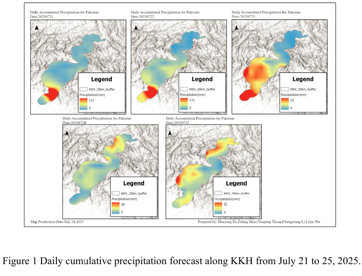
Combined with the precipitation forecast based on the NCFP GFS model on July 24, 2025 and multi-source data such as lithology, DEM and hydrological conditions along the Karakoram Highway, the TRIGRS model was adopted to conduct the landslide risk assessment in the northern area which is greatly affected by rainfall. The NCEP GFS precipitation forecast indicates that on July 24th, there will be a rainfall process of 10 to 25 mm around Gilgit, mainly concentrated in the northern region (Figure 1). Although the single magnitude is not extreme, and compared with the previous two days, the rainfall shows a relatively obvious downward trend. However, under the monsoon background (with accumulated rainfall in the early stage), it is sufficient to cause a significant increase in the probability of shallow collapses, slides and small debris flows. Rainfall infiltration increases the pore water pressure of the slope body, reduces the effective stress and shear strength, and may rapidly form saturated weak layers within loose deposits or strongly weathered zones, thereby pushing the slope in a critical stable state towards the instability threshold.
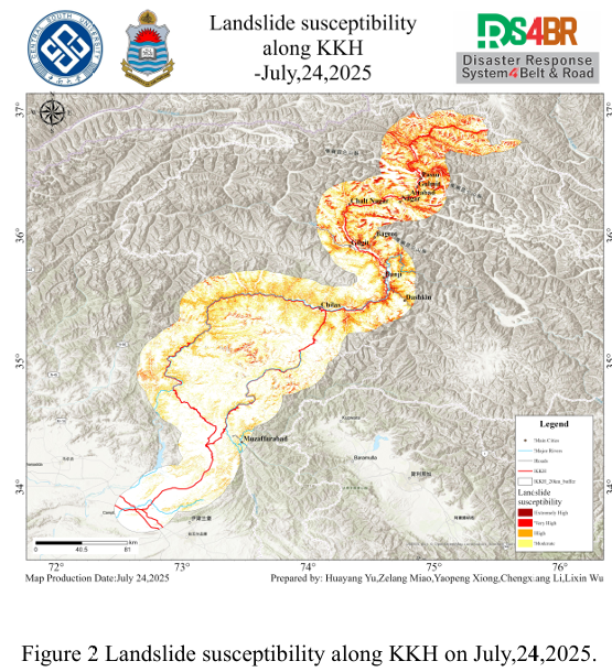
The assessment results show (Figure 2) that the extremely high and highly prone areas are mainly concentrated in the mountain corridors with heavy rainfall intensity, strong terrain undulations, dense river valleys and concentrated engineering cut slopes, including Attabad, Gilgit, Passu, Nagar and other places, as well as the steep slopes along the sides of major rivers and transportation arteries such as the Karakoram Highway (KKH). These areas are usually controlled by active fault zones, with well-developed and fragmented rock mass structural planes, large slopes, significant relative height differences, and abundant material sources. Therefore, they exhibit higher instability sensitivity under the trigger of rainfall.
From the results of susceptibility, it can be seen that the sections along the KKH, such as the Gilgit-Hunza-Passu corridor, GilGit-Skardu, and Astreo-Dashkin, which are highly prone to occurrence, should be regarded as key risk areas. Special attention should be paid to disasters such as high and steep cutting slopes and mudslides during and after rainfall.
结合 2025 年 7 月 24 日基于 NCFPGFS 模式的降水预报与喀喇昆仑公路沿线的岩性、DEM、水文条件等多源数据,采用TRIGRS模型,对收降雨影响较大的北部地区展开滑坡危险性评估。NCEPGFS降水预报显示,7月24日Gilgit 周边出现 10–25mm 的降雨过程,且主要集中于北部区域(图1),尽管单次量级并非极端,并且相对于前两天,降雨量呈现较为明显的下降趋势,但在季风背景下(存在前期累积降雨)足以导致浅层崩塌、滑塌与小型泥石流的发生概率显著升高。降雨入渗提高了坡体孔隙水压力、降低了有效应力与抗剪强度,并可能在松散堆积物或强风化带内快速形成饱和薄弱层,从而将处于临界稳定状 态的斜坡推向失稳阈值。
评估结果显示(图2),极高、高易发性区域主要集中于降雨强度大、地形起伏强烈、河谷密布且工程切坡集中的山地走廊,包括 Attabad、Gilgit、Passu、Nagar等地,以及沿主要河流与喀喇昆仑公路(KKH)等交通干线两侧的陡峻边坡。这些区域通常受活动断裂带控制,岩体结构面发育且破碎,坡度大、相对高差显著,物源条件充足,因而在降雨触发下表现出更高的失稳敏感性。
从易发性结果可以看出,沿KKH 穿越的Gilgit—Hunza—Passu 走廊等高易发性路段应被视为重点风险区段,需重点关注在降雨过程中与雨后的高陡切坡、泥石流等灾害。