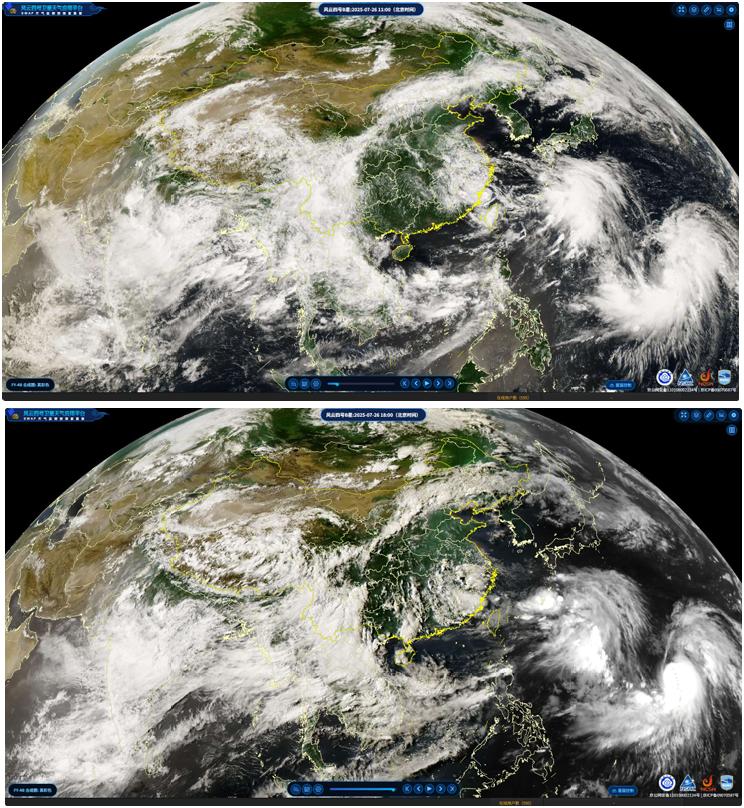
Figure 2 Cloud distribution observed by FY-4B at 3:00 and 10:00 UTC on July 26, 2025.
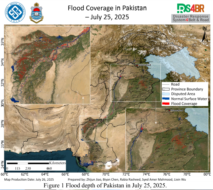
Based on multi-source remote sensing data acquired on July 25, 2025—including Sentinel-1, Sentinel-2, Landsat-8, and Landsat-9—the latest flood inundation extent across Pakistan was dynamically monitored and comprehensively assessed using the KDFIMv2 algorithm (Fig. 1). In parallel, FY-4B geostationary meteorological satellite imagery (Fig. 2) and forecasts from the NCFP GFS global precipitation model (Fig. 3) were integrated to assess potential meteorological changes and secondary disaster risks.
Fig. 1 presents the spatial distribution of flood inundation as of July 25, 2025. Remote sensing monitoring indicates that flood conditions remain critical in Punjab Province, particularly in the Chenab and Jhelum River basins, where floodwaters have significantly expanded—prompting an urgent need for organized relief efforts. Water accumulation upstream of the Chashma Reservoir has increased, and the Indus River’s main channel has visibly widened. Continuous monitoring of reservoir operation and embankment safety is essential. In Sindh Province, floodwaters on agricultural land have started to recede; however, the riverine area of the Indus continues to expand, marking the onset of the seasonal flood phase.
Fig. 2 shows cloud imagery captured by the FY-4B satellite at 03:00 and 10:00 UTC on July 26. The images reveal transient cumulus development over Punjab Province, which dissipated quickly. By 10:00 UTC, most of Pakistan was experiencing clear weather, providing favorable meteorological conditions for post-flood rescue and recovery operations.
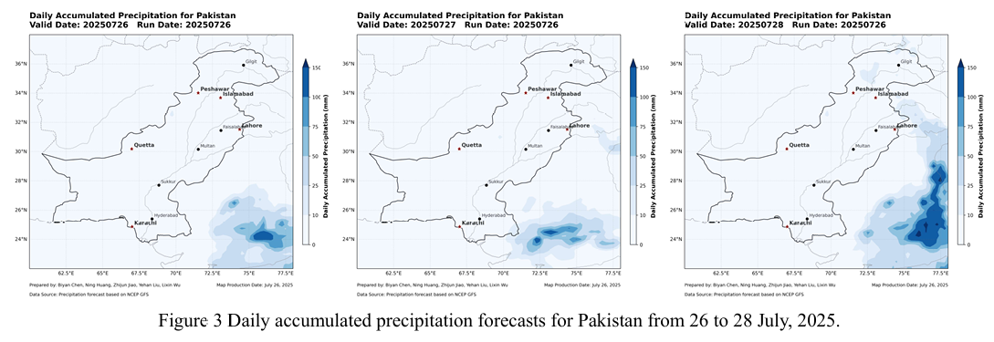
Fig. 3 displays precipitation forecasts from the NCFP GFS model. The results indicate no significant rainfall across most regions of Pakistan between July 27 and 28, except for localized light precipitation in the north on July 28. The overall stable weather pattern supports ongoing flood relief and regional recovery efforts. However, renewed heavy rainfall is forecast to arrive from India on July 29, warranting vigilance due to potential secondary disaster risks.
根据2025年7月25日获取的Sentinel-1、Sentinel-2、Landsat-8 与 Landsat 9 等多源遥感数据,采用KDFIMv2算法对巴基斯坦境内的洪水淹没范围(Fig.1) 进行了最新动态监测与综合评估。同时,结合FY-4B静止气象卫星云图(Fig.2) 与NCFP GFS全球降水预报模型(Fig.3),研判未来区域气象变化及次生灾害风 险。
Fig.1 显示2025 年7月25日的洪水淹没分布结果。遥感监测表明,旁遮普 省淹没形势依然严峻,特别是奇纳布河与杰赫勒姆河流域,洪水扩展明显,亟需 组织有效救援。Chashma水库上游积水面积有所增加,印度河主干道水面也出现 扩张,需持续关注水库调度与堤防安全。信德省农田积水开始逐渐消退,但印度 河河道水域面积持续扩大,已进入季节性涨水阶段。
Fig.2 为 FY-4B 卫星于7月26日UTC时间3时与10时获取的云图结果。 图像显示,旁遮普省上空曾短时出现积云,但很快消散,截至10时,巴基斯坦 大部地区天气晴朗,为灾后救援与恢复提供了有利气象条件。
Fig.3 为 NCFP GFS 模型的未来降水预报。结果显示,7月27日至28日期 间,巴基斯坦大部分地区无明显降水过程。仅28日北部有少量降水,整体气象 形势稳定,有利于洪涝救援行动与受灾区域恢复工作推进。但未来29日新一轮 暴雨从印度过来,仍需警惕。