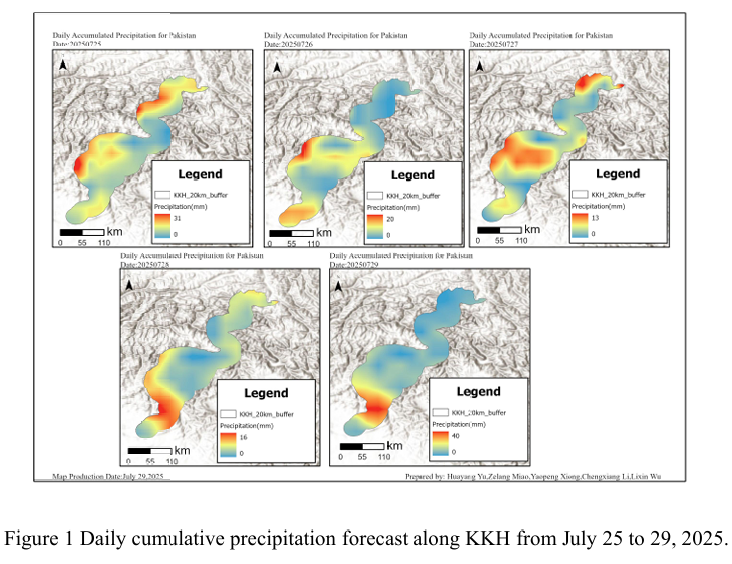
Combined with the precipitation forecast based on the NCFP GFS model on July 29, 2025 and multi-source data such as lithology, DEM and hydrological conditions along the Karakoram Highway, the TRIGRS model was adopted to conduct the landslide risk assessment in the northern area that was greatly affected by rainfall. The NCEP GFS precipitation forecast shows that the rainfall along the Karakoram Highway on July 29th will increase compared to July 28th. In terms of spatial distribution, it is mainly concentrated in the southern region, with less rainfall in the northern mountainous areas. At this time, the infiltration of rainfall further increases the pore water pressure of the slope, significantly reducing the effective stress and shear strength, and is prone to form a local saturated weak layer. These factors will cause the slope to rapidly evolve from the critical stable state to the instability threshold in the TRIGRS model, and the triggering probability of shallow collapses, slides or small debris flows will increase significantly.
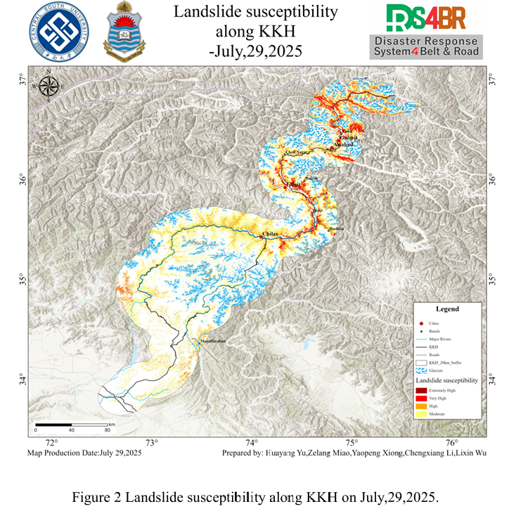
The assessment results show (Figure 2) that the extremely high and high-susceptibility areas are mainly distributed in a band-like pattern along the main river valley corridors in the north, concentrated in mountainous areas with intense terrain undulations and deep rivers, especially in the sections around Chilas, Gilgit, Attabad and north of Gulmit. These areas are generally characterized by steep slopes and deep valleys, with a dense density of steep slopes. Moreover, the foot of the slopes is adjacent to major rivers and traffic arteries, locally forming high-value aggregation areas of landslides, which constitute the core of the high-risk landslide pattern in the north. In contrast, although the southern region was more affected during the concentrated rainfall period, especially with a high rainfall of 40mm on July 29th, the overall susceptibility to landslides was still mainly at a medium level, and the distribution was relatively scattered, presenting a patchy pattern. This phenomenon may be related to the extensive glacier coverage in the area south of Chilas. Overall, although the rainfall in the south is greater, the spatial range of extremely high and high-susceptibility areas has not expanded significantly as a result. Although the northern region has relatively low rainfall, due to the terrain conditions and the dense distribution of river valleys, the high-incidence areas of landslides still maintain a stable pattern, and the coverage area has not shown significant changes.
From the results of susceptibility, it can be seen that the Chila-Gilgit section along the KKH, the area around Attabad, and the section north of Gulmit, which are highly prone to occurrence, should be regarded as key risk areas. Special attention should be paid to high and steep cutting slopes, mudslides and other disasters during and after rainfall
结合 2025 年 7 月 29日基于 NCFPGFS 模式的降水预报与喀喇昆仑公路沿线的岩 性、DEM、水文条件等多源数据,采用TRIGRS模型,对受降雨影响较大的北部地区展开滑坡危险性评估。NCEPGFS降水预报显示,7 月 29 日喀喇昆仑公路沿线降雨量相较于7 月28日有所提升,在空间分布上主要集中于南部地区,北部山区降雨较少,此时降雨入渗 进一步提高了坡体孔隙水压力,显著降低了有效应力与抗剪强度,容易形成局部饱和薄弱层。这些因素在 TRIGRS 模型中将使边坡从临界稳定状态快速向失稳阈值演化,浅层崩塌、滑塌或小型泥石流的触发概率大幅上升。
评估结果显示(图2),极高和高易发区主要沿北部主要河谷走廊呈带状分布,集中分布在地形起伏剧烈、河流深切的山地区域,尤以Chilas、Gilgit、Attabad周边及Gulmit以北 路段最为典型。这些区域普遍坡陡谷深,陡坡密集,且坡脚紧邻主要河道与交通干线,局部形成滑坡高值的聚集区,构成了北部滑坡高风险格局的核心。相比之下,南部地区虽在降雨 集中期受到了更大影响,特别是在7月29日降雨量达到40mm的高值,但滑坡易发性整体仍以中等等级为主,分布较为零散,呈现斑块状。这种现象可能与Chilas以南地区广泛分布的冰川覆盖有关。总体来看,虽然南部降雨量更大,但极高与高易发区的空间范围并未随之显著扩展。而北部地区尽管降雨量相对较低,但由于地形条件和河谷密集分布,滑坡高易发区仍维持稳定格局,覆盖范围未见明显变化。
从易发性结果可以看出,沿 KKH 穿越的Chilas-Gilgit路段、Attabad周边区域 、Gulmit以北段等高易发性路段应被视为重点风险区段,需重点关注在降雨过程中与雨后的高陡切坡、泥石流等灾害。