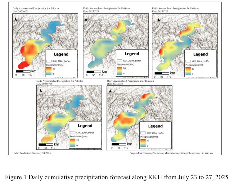
Combined with the precipitation forecast based on the NCFP GFS model on July 25, 2025 and multi-source data such as lithology, DEM and hydrological conditions along the Karakoram Highway, the TRIGRS model was adopted to conduct the landslide risk assessment in the northern area which is greatly affected by rainfall. The precipitation forecast of NCEP GFS shows that from Gilgit to Khyber in the northern mountainous area of Pakhtunkhwa on July 25th, there will be concentrated rainfall, with local cumulative rainfall reaching 10 - 30 mm (Figure 1). This reduction is slightly lower than the previous period and is not extreme overall. However, it is during the peak period of the monsoon, and the continuous accumulated rainfall across the country has increased compared to the average of previous years. The northern mountainous areas have experienced particularly frequent rainfall, and the heavy rainfall in the west is more significant today. At this time, the infiltration of rainfall further increases the pore water pressure of the slope body, significantly reduces the effective stress and shear strength, and is prone to form a local saturated weak layer. These factors will cause the slope to rapidly evolve from the critical stable state to the instability threshold in the TRIGRS model, and the triggering probability of shallow collapses, slides or small debris flows will increase significantly.
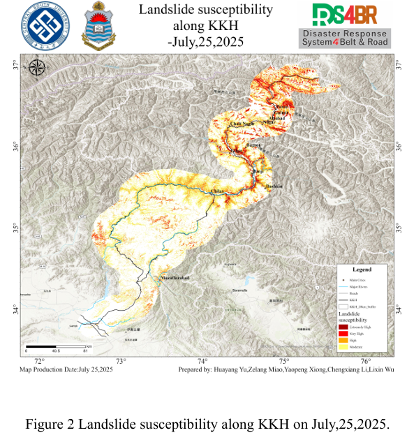
The assessment results show (Figure 2) that the susceptibility levels exhibit distinct regional characteristics in space. The extremely high and highly susceptible areas are mainly distributed in a continuous band-like pattern along the northern river valley corridor, concentrated in mountainous areas with intense terrain undulations and strong river cuts. Around areas such as Chilas, Gilgit, Chalt and Nagar, steep slopes are dense and the foot of the slopes is close to major rivers or traffic arteries, and some local areas show high-value aggregation characteristics. In contrast, the transition areas of valleys and the gentle slopes are mostly of medium grade, with relatively scattered distribution and local patchy appearance. It can be seen from the figure that along the Karakoram Highway, there is a strong spatial consistency between the high-grade area and the engineering cut slope, and obvious high-risk zones are formed on both sides of the steep slopes. In contrast, areas with gentler slopes are mostly at a low susceptibility level, highlighting the differentiated responses driven by both rainfall and terrain.
From the results of susceptibility, it can be seen that high-susceptibility sections such as the Chilas-Dashkin and Gilgit-Hunza-Passu corridors along the KKH should be regarded as key risk areas, and special attention should be paid to disasters such as high and steep cutting slopes and mudslides during and after rainfall.
结合 2025年7月 25日基于 NCFPGFS 模式的降水预报与喀喇昆仑公路沿线的岩性、DEM、水文条件等多源数据,采用TRIGRS模型,对收降雨影响较大的北部地区展开滑坡危险性评估。NCEPGFS降水预报显示,7月25日Gilgit至 Khyber Pakhtunkhwa 北部山区降雨集中,局地累积雨量达10 – 30 mm(图1)。这一降量较前期有所回落,且整体并非极端,但正值季风高峰期间,全国持续累积降雨较常年有所提升,北部山区降雨尤为 频繁,西部强降雨在今日较为显著。此时降雨入渗进一步提高了坡体孔隙水压力,显著降低了有效应力与抗剪强度,容易形成局部饱和薄弱层。这些因素在 TRIGRS 模型中将使边坡从临界稳定状态快速向失稳阈值演化,浅层崩塌、滑塌或小型泥石流的触发概率大幅上升。
评估结果显示(图2),易发性等级在空间上呈现明显的分区特征,极高与高易发区主 要沿北部河谷走廊呈连续带状分布,集中于地形起伏剧烈、河流强烈切割的山区。Chilas、 Gilgit、Chalt、Nagar 等地段周边,陡坡密集且坡脚紧邻主要河流或交通干线,局部区域显 示出高值聚集特征。相较之下,谷地过渡区及低缓山坡多表现为中等级,易发性分布相对零 散,局部呈斑块状。从图上可以看出,在喀喇昆仑公路沿线,高等级区与工程切坡存在较强 的空间一致性,陡峭边坡两侧形成明显的高风险带;而坡度较缓区域则多为低易发等级,突出了降雨与地形共同驱动的差异化响应。
从易发性结果可以看出,沿 KKH 穿越的Chilas-Dashkin、Gilgit—Hunza—Passu 走廊等高易发性路段应被视为重点风险区段,需重点关注在降雨过程中与雨后的高陡切坡、泥石 流等灾害。