


Based on multi-source remote sensing data acquired between July 16 and 29, 2025, including Sentinel-1, Sentinel-2, Landsat-8, and Landsat-9, combined with the KDFIMv2 algorithm, a dynamic monitoring and comprehensive assessment of flood inundation extent and water depth was conducted across Pakistan.
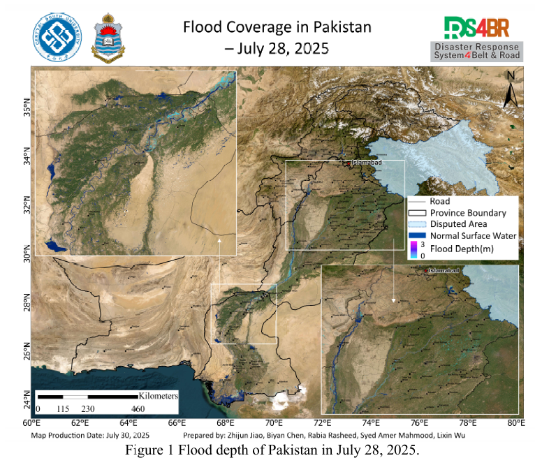
Fig. 1 illustrates the spatial distribution of flood water depth on July 28, 2025. The analysis indicates that large areas of farmland in Punjab Province remain inundated, and the water surface expansion along the Indus River mainstem has stabilized. In contrast, flood conditions in Sindh and Khyber Pakhtunkhwa (KP) Provinces appear relatively mild, with limited inundation extent and shallow depths.
Fig. 2 shows the flood extent on July 29. Due to satellite observation limitations, coverage was restricted to parts of western Sindh and the northeastern corner of Punjab. Results reveal that only the northeastern area of Punjab still experiences flooding in river channels and agricultural zones, likely associated with recent localized rainfall events.
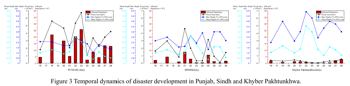
Fig. 3 depicts the temporal evolution of flood conditions in Punjab, Sindh, and KP since July 16. Although an overall recession trend is observed, slight increases in inundated areas in some regions suggest residual water movement toward downstream basins and the influence of new rainfall episodes.
Fig. 4, derived from FY-4B geostationary satellite imagery at 11:00 UTC on July 29, shows a large convective cloud system advancing toward Pakistan. This poses an elevated risk of heavy precipitation and localized severe weather, particularly in mountainous areas of Sindh and KP, warranting heightened vigilance.
Fig. 5 presents precipitation forecasts from the NCFP GFS global model. The outputs predict a new round of moderate to heavy rainfall over the next two days in Punjab and KP, with the potential for localized intense storms. Associated hydrological responses, such as flash floods and landslides, are possible, and precautionary disaster risk reduction measures are strongly recommended.
根据2025年7月16日至29日期间获取的Sentinel-1、Sentinel-2、Landsat 8、Landsat-9 等多源遥感数据,并结合KDFIMv2 算法,对巴基斯坦境内的洪水淹没范围与水深进行了动态监测与综合评估。
图1展示了2025年7月28日的洪水水深空间分布。分析表明,旁遮普省仍有大面积农田被洪水淹没,印度河主河道水面扩张后整体保持稳定。相比之下,信德省与开伯尔-普赫图赫瓦省(KP)洪涝态势较为平缓,淹没面积和水深均处于较低水平。
于较低水平。图2呈现了7月29日的洪水淹没范围。由于遥感观测覆盖受限,仅获取了信德省西部小范围区域及旁遮普省东北角的数据。结果显示,仅在旁遮普东北部 观测到仍存在一定规模的河道及农田淹没,推测与近期局地降雨过程相关。
图3反映了7月16日以来三省洪涝灾情的时序演变过程。评估显示,尽管总体洪水呈现退减趋势,但局部地区淹没范围略有回升,可能受控于前期积水向下游输移以及最新一轮降水影响。
图4为FY-4B静止气象卫星于2025年7月29日11时(UTC)获取的强对流云团分布图。监测结果显示,一片大范围强对流云团正快速向巴基斯坦境内推进,特别是信德和KP山区面临较高强降水和局地强对流天气风险,需引起高度重视。
图5展示了NCFP GFS全球降水预报模型输出。预测显示,未来两天旁遮普省与KP山区将迎来新一轮中到大雨过程,局部地区可能出现大到暴雨,存在引发山洪、滑坡等次生灾害的风险,建议相关部门提前部署防灾减灾应急措施。