Based on multi-source remote sensing data acquired from July 16 to 27, 2025, including Sentinel-1, Sentinel-2, Landsat-8, and Landsat-9, the flood extent and water depth across Pakistan were dynamically monitored and comprehensively assessed using the KDFIMv2 algorithm.
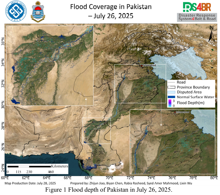
Fig. 1 illustrates the spatial distribution of floodwater depth on July 26, 2025. The results indicate a general recession trend in flooding conditions, with water depth across most regions falling below 1 meter. However, localized segments along the main channel of the Indus River still exhibit depths exceeding 2 meters.
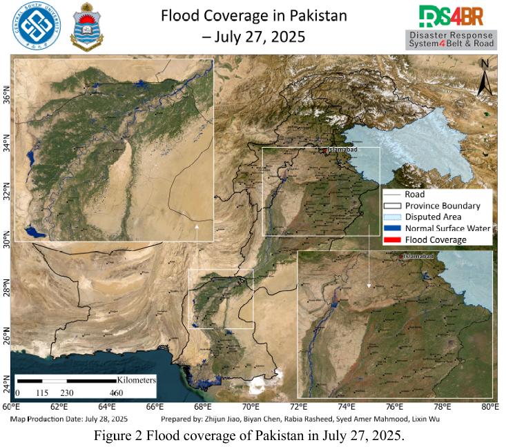
Fig. 2 presents the flood inundation extent on July 27, based on data covering parts of Punjab Province. A significant reduction in inundation extent was observed, suggesting accelerated flood recession with no signs of further expansion.
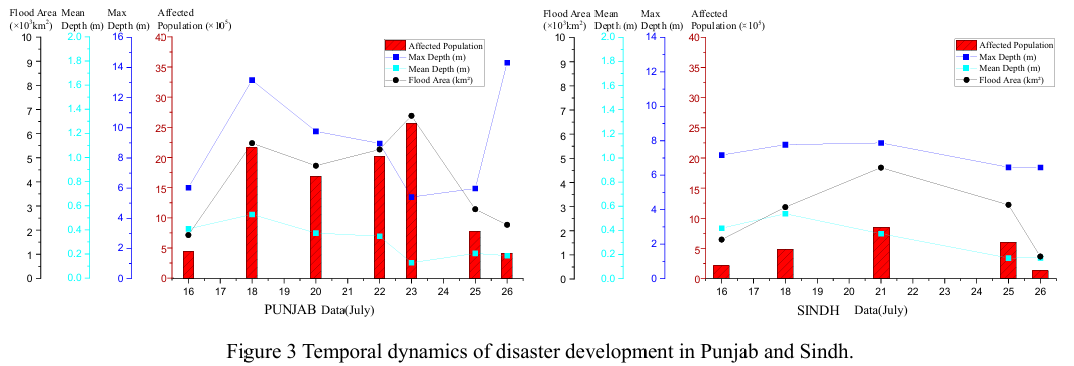
Fig. 3 illustrates the temporal evolution of flood conditions in Sindh and Punjab provinces since July 16, 2025. Remote sensing-based assessment indicates that Punjab experienced significantly larger inundated areas and a higher number of affected populations compared to Sindh. Most flooded regions exhibited water depths below 0.5 meters, while maximum depths exceeding 10 meters were observed in major river channels and reservoir zones. Overall, the flooding situation is currently in a continuous recession phase.
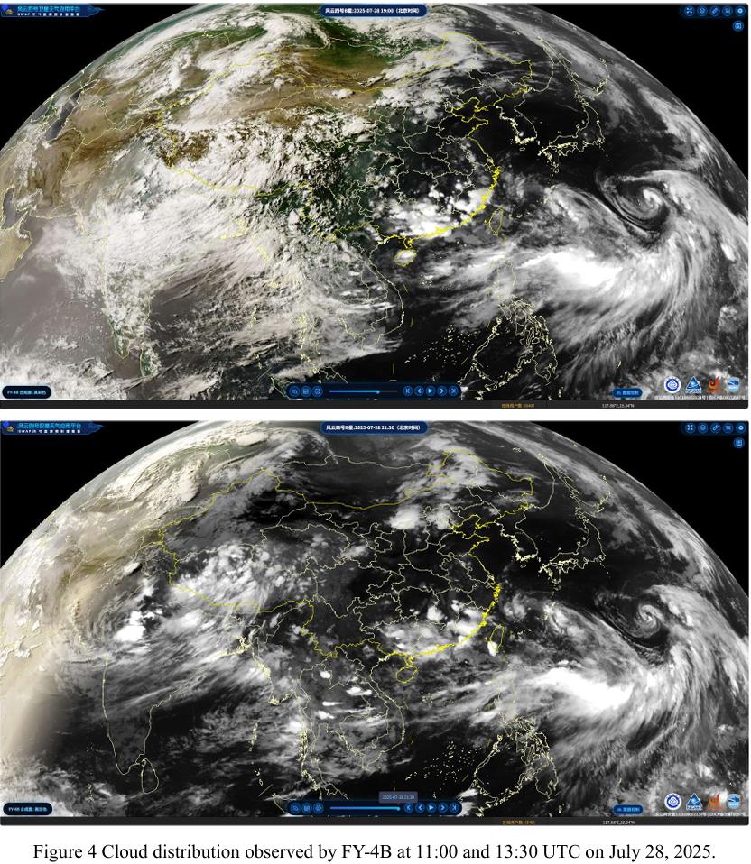
Fig. 4 shows FY-4B geostationary satellite cloud imagery from 11:00 UTC on July 27. A large convective cloud mass formed over southern Khyber Pakhtunkhwa (KP) and rapidly moved northward, indicating the potential for short-term heavy rainfall or severe convective weather. Continuous monitoring is recommended.
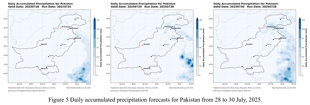
Fig. 5 provides the NCFP GFS global precipitation forecast. The model predicts a new round of widespread precipitation over KP and Gilgit-Baltistan (GB) regions on July 28–29, which may exacerbate mountain runoff and increase the risk of secondary geological disasters. Proactive flood preparedness is advised.
根据2025年7月16日至27日期间获取的Sentinel-1、Sentinel-2、Landsat 8 与Landsat-9 等多源遥感数据,采用KDFIMv2算法对巴基斯坦境内洪水淹没范围与水深进行动态监测与综合评估。
图1 显示了2025年7月26日的洪水水深空间分布结果。结果表明,整体洪水形势呈现减弱趋势,大多数区域水深已降至1米以下,仅印度河主干河道部分区段水深仍超过2米。
图 2 显示了7月27 日的洪水淹没范围,该日遥感数据仅覆盖旁遮普省区域。监测显示洪水退去加快,淹没范围持续收缩,未观察到明显的扩展现象。
图3 展示了自2025年7月16日以来信德省与旁遮普省的洪涝灾情演变过程。遥感监测评估结果表明,旁遮普省的淹没范围及受灾人口数量均显著高于信德省。大多数受淹区域水深低于0.5米,仅印度河主河道及部分库区区域水深可 达10米以上。目前整体洪涝形势已处于持续消退阶段。
图4 显示了FY-4B静止气象卫星在7月27日11时(UTC)开始监测到的 云团演变情况。结果表明,KP省南部生成一片大范围云团,快速北移,存在短时强降水或对流天气风险,需加强监测与预警。
图5 为NCFP GFS全球降水预报结果,模型预测显示7月28日至29日期间,KP省及GB地区将出现新一轮大范围降水,可能加剧山区径流与地质灾害风险,相关区域应提前做好防汛响应准备。