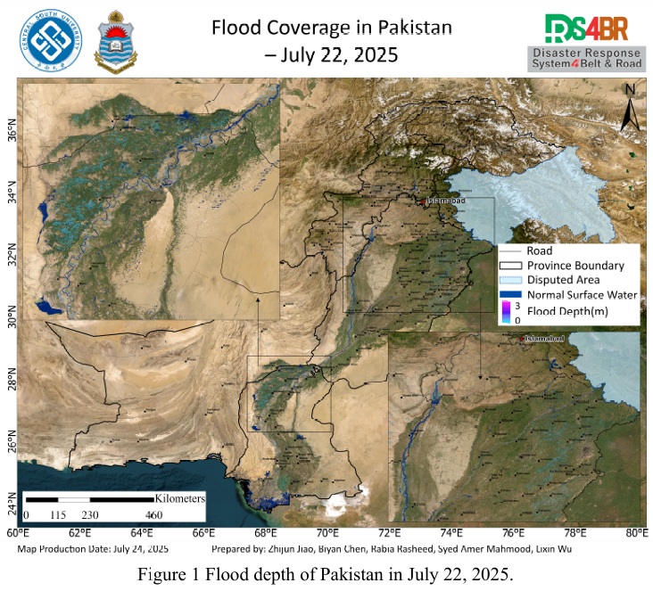
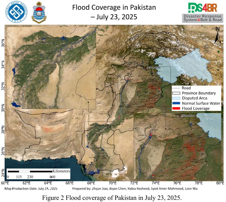
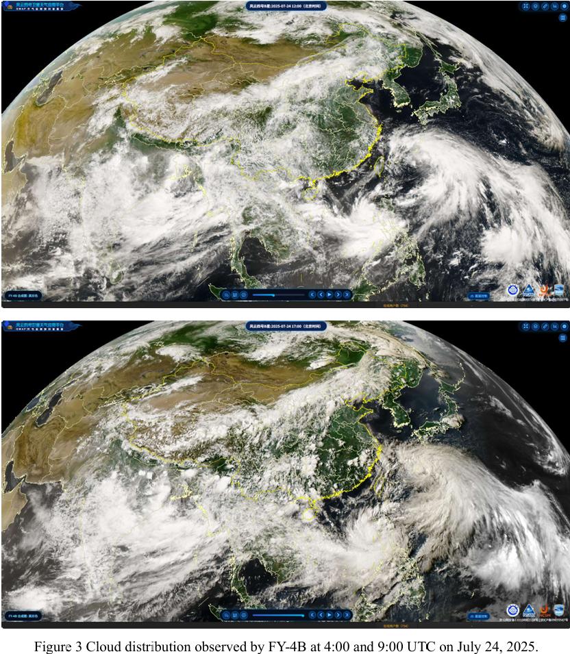
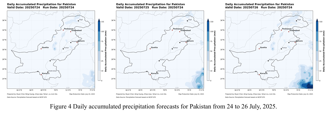
Based on multi-source optical and radar remote sensing imagery from Sentinel-1, Sentinel-2, Landsat-8, and Landsat-9 acquired between July 22 and 23, 2025, and processed using the KDFIMv2 algorithm, a dynamic assessment and integrated analysis of flood depth (Fig. 1) and inundation extent (Fig. 2) across Pakistan has been conducted. Meteorological changes and future disaster risks were further examined with reference to FY-4B geostationary satellite cloud imagery (Fig. 3) and the NCFP GFS global precipitation forecast model (Fig. 4).
Fig. 1 illustrates the flood water depth distribution on July 22, 2025. Remote sensing observations indicate that shallow waterlogging persists across Sindh Province, with generally low water depths. The northern part of the province shows signs of recession, and no new significant expansion was observed in the south. In northeastern Punjab, agricultural fields have remained inundated for a prolonged period, with water depths stabilized below 1 meter, which is having a substantial impact on agricultural activities. Overall, water extent along the main course of the Indus River remains relatively stable, indicating that the flooding is still largely within channel control.
Fig. 2 shows the flood inundation extent as of July 23, 2025. Valid observations were primarily available for the Punjab Province. The analysis indicates no significant improvement in the flood situation. Particularly around the river basin, previously scattered waterlogged areas have started to merge into larger patches, with increasing inundation of agricultural land. There is also an observable trend of worsening water accumulation near the main Indus River channel and upstream around the Chashma Reservoir, highlighting the need for continued monitoring of water dynamics and embankment stability.
Fig. 3 presents cloud imagery captured by the FY-4B geostationary satellite on July 23. From 04:00 to 09:00 UTC, dense cloud coverage was observed over Pakistan, which then rapidly dissipated after 09:00, indicating a short-term weakening of convective activity.
Fig. 4 shows future precipitation forecasts based on the NCFP GFS model. It predicts that from July 23 to 24, no significant rainfall is expected across northern Pakistan and major flood-affected regions. This presents a favorable window for post disaster emergency response and flood control. It is recommended that relevant authorities expedite drainage operations and agricultural recovery, while also advancing the implementation of long-term disaster prevention and mitigation measures to strengthen overall regional resilience.
根据2025年7月22日至23日的Sentinel-1、Sentinel-2、Landsat-8与Landsat 9 等多源光学与雷达遥感影像,并采用KDFIMv2算法,对巴基斯坦境内的洪水水深(图1)与淹没范围(图2)进行了最新动态评估与综合分析。同时,结合 FY-4B 静止气象卫星云图(图3)与NCFP GFS全球降水预报模型(图4),进一步研判区域气象变化及未来灾害风险趋势。
图1展示了2025年7月22日的洪水水深分布情况。遥感监测结果显示,信 德省整体仍存在浅层积水,水深普遍较浅,北部地区积水已有所减退,南部区域则未出现明显扩张迹象。旁遮普省东北部部分农田积水持续时间较长,水深稳定在1米以下,对农业生产造成了实质性影响。总体来看,印度河干流沿线水体变化不大,河道控制能力仍较稳定。
图2反映了2025年7月23日的洪水淹没分布结果。本次观测数据主要覆盖旁遮普省。分析显示,该区域洪水形势未出现明显好转,尤其在流域周边,原本零星分布的积水区域已开始连片发展,农田淹没面积有进一步扩大的趋势。印度河主干河道及其上游 Chashma 水库周边,也出现积水加重的迹象,需持续关注水体变化与堤防安全风险。
图3为FY-4B静止气象卫星于7月23日获取的云图,显示当日UTC时间4时至9时,巴基斯坦上空云层覆盖密集,但在9时后迅速减弱消散,表明短期内强对流活动已明显缓解。
图4则基于NCFP GFS模型对未来降水趋势进行了预测,结果显示2025年 7 月23 日至24日期间,巴基斯坦北部及主要洪灾影响区域未有显著降水过程。这一变化为当前灾后应急救援与灾情控制提供了有利窗口期。建议相关部门迅速推进受灾区域的排涝与农业恢复工作,并加快长期防灾减灾措施的部署,以提升区域综合防灾能力。