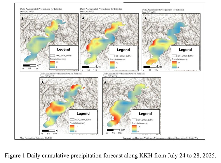
Combined with the precipitation forecast based on the NCFP GFS model on July 28, 2025 and multi-source data such as lithology, DEM and hydrological conditions along the Karakoram Highway, the TRIGRS model was adopted to conduct the landslide risk assessment in the northern area that was greatly affected by rainfall. The NCEP GFS precipitation forecast shows that on July 28th, there will be less rainfall along the Karakoram Highway, mainly concentrated in the southern region. The cumulative rainfall will be the same as that on July 27th (Figure 1), both below 20mm, and the overall situation will not be extreme, with only a small amount of rainfall. However, it is during the peak period of the monsoon, and the continuous cumulative rainfall across the country will be higher than the average of previous years. At this time, the infiltration of rainfall further increases the pore water pressure of the slope body, significantly reduces the effective stress and shear strength, and is prone to form a local saturated weak layer. These factors will cause the slope to rapidly evolve from the critical stable state to the instability threshold in the TRIGRS model, and the triggering probability of shallow collapses, slides or small debris flows will increase significantly.
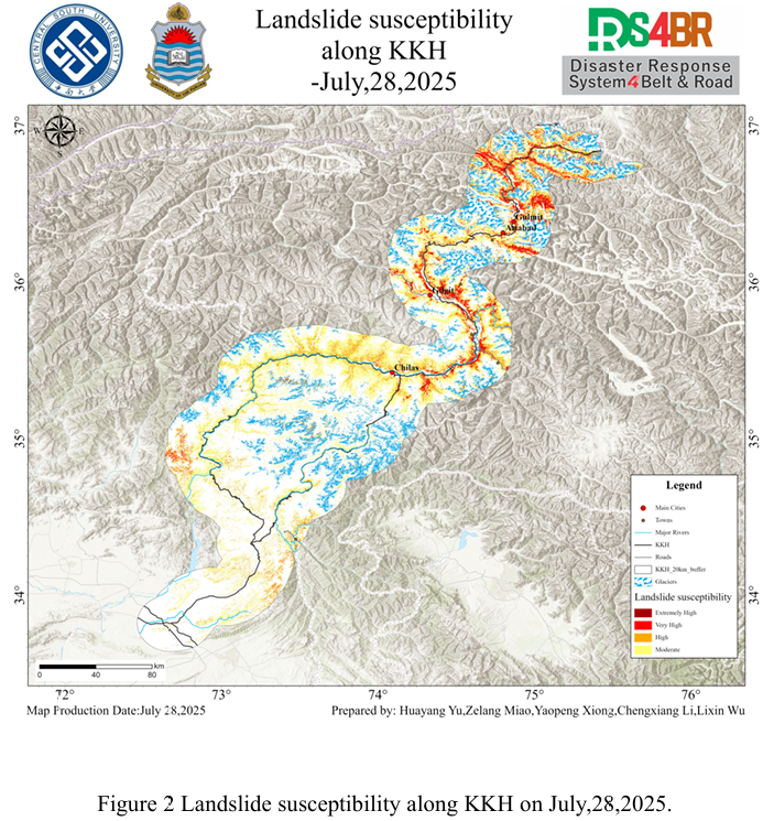
The assessment results show (Figure 2) that due to the overall low rainfall on the 27th and 28th, the overall spatial pattern of the areas prone to high rainfall remained basically consistent. However, on the 28th, the coverage of the high-susceptibility areas was somewhat reduced, mainly concentrated on the sections north of Chilas. The extremely high and highly prone areas are still distributed in a band-like pattern along the main river valley corridors in the north, and the distribution areas are mostly mountainous zones with intense terrain undulations and deep rivers. In the areas around Chilas, Gilgit, Attabad and the sections north of Gulmit, steep slopes are densely distributed and the foot of the slopes is close to major rivers and traffic arteries, resulting in a phenomenon of high-value aggregation in some local areas. In contrast, the area south of Chilas is covered by a large area of glaciers, mostly of medium susceptibility grades. The overall distribution is relatively scattered and shows local patchy characteristics.
From the results of susceptibility, it can be seen that the Chilas-Gilgit section along the KKH, the area around Attabad, and the section north of Gulmit, which are highly prone to occurrence, should be regarded as key risk areas. Special attention should be paid to high and steep cutting slopes, mudslides and other disasters during and after rainfall.
结合 2025 年 7 月 28日基于 NCFPGFS 模式的降水预报与喀喇昆仑公路沿线的岩性、DEM、水文条件等多源数据,采用TRIGRS模型,对受降雨影响较大的北部地区展开 滑坡危险性评估。NCEPGFS降水预报显示,7 月 28日喀喇昆仑公路沿线降雨较少,主要 集中于南部地区,累积雨量与27日降雨持平(图1),都在20mm以下,且整体并非极端,只有少部分有降雨,但正值季风高峰期间,全国持续累积降雨较常年有所提升。此时降雨入渗进一步提高了坡体孔隙水压力,显著降低了有效应力与抗剪强度,容易形成局部饱和薄弱层。这些因素在 TRIGRS 模型中将使边坡从临界稳定状态快速向失稳阈值演化,浅层崩塌、滑塌或小型泥石流的触发概率大幅上升。
评估结果显示(图2),由于27、28 日降雨量总体较低,降雨高易发区域的总体空间 格局基本保持一致,但28日高易发区覆盖范围有所缩减,主要集中在 Chilas 以北的路段。极高及高易发区依然沿北部主要河谷走廊呈带状分布,分布区域多为地形起伏剧烈、河流深切的山地带。Chilas、Gilgit、Attabad 等地周边以及Gulmit 以北路段,陡坡密布且坡脚紧邻 主要河道和交通干线,局部区域形成高值聚集现象。相比之下,Chilas以南区域有较大范围冰川覆盖,多为中等易发等级,整体分布较为零散,并呈现局部斑块状特征。
从易发性结果可以看出,沿 KKH 穿越的Chilas-Gilgit路段、Attabad周边区域 、Gulmit 以北段等高易发性路段应被视为重点风险区段,需重点关注在降雨过程中与雨后的高陡切坡、泥石流等灾害。