

根据2025年7月16日至31日期间获取的Sentinel-1、Sentinel-2、Landsat-8、Landsat-9等多源遥感数据,结合KDFIMv2洪水反演算法,对巴基斯坦境内洪水淹没范围与水深开展了动态监测与综合评估。
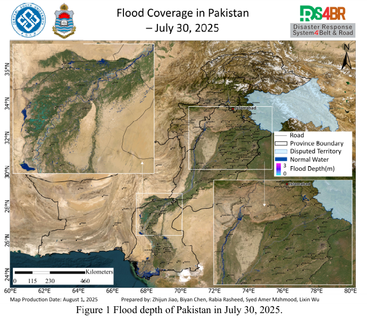
图1展示了2025年7月30日的洪水水深空间分布图。整体来看,淹没区域水深较浅,但主要河道内水深仍超过3米。信德省多数积水分布于农田区域,水深相对较低,反映出洪水正处于消退阶段。
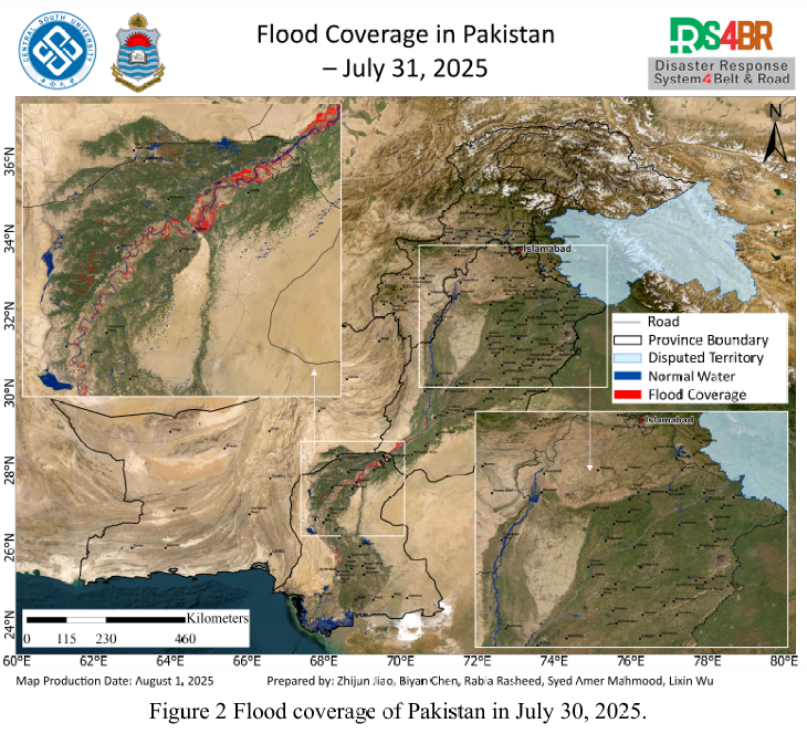
图2为2025年7月31日的洪水淹没范围图。由于遥感影像覆盖范围有限,仅监测到信德省及印度河主干流。结果显示,信德省境内印度河明显扩张,上游洪水逐步向下游转移。河道外主要积水区域仍集中在农田,提示农业生产仍受一定影响。
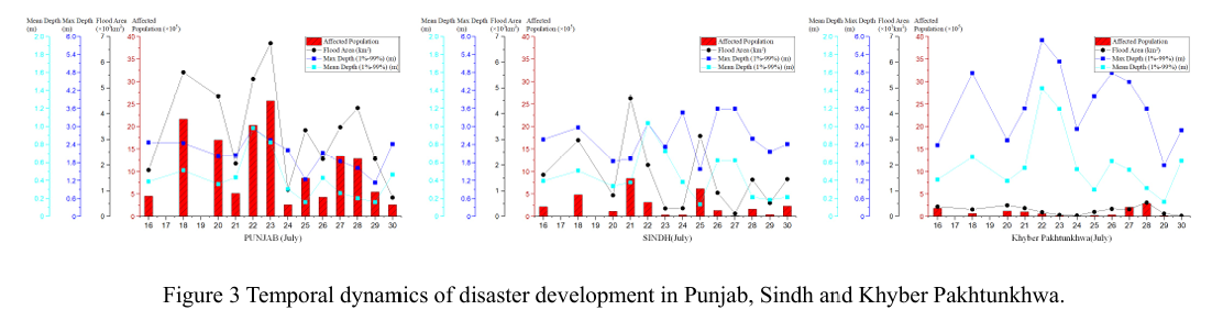
图3反映了自7月16日以来旁遮普省、信德省与开伯尔-普赫图赫瓦省(KP)等主要受灾区域的洪涝演变过程。整体趋势表明,洪水淹没范围持续缩减、水深逐步下降,洪水影响减弱,为灾后恢复及农田排涝提供了有利条件。
图4为FY-4B静止气象卫星于2025年7月31日获取的强对流云团监测图,显示巴基斯坦东部地区全天云系活动频繁,强对流天气过程活跃,需警惕局地短时强降水的发生。
图5为NCFP GFS全球降水预报模型的未来两天降水预测结果。降水仍集中在北部山区,覆盖KP省、吉尔吉特-巴尔蒂斯坦(GB)及旁遮普北部等区域,局部地区可能出现中到大雨,需防范山洪、滑坡等次生地质灾害风险。
Based on multi-source remote sensing data acquired from July 16 to 31, 2025—including Sentinel-1, Sentinel-2, Landsat-8, and Landsat-9—and using the KDFIMv2 flood inversion algorithm, dynamic monitoring and integrated assessment of flood extent and water depth were conducted across Pakistan.
Fig. 1 presents the spatial distribution of flood water depth on July 30, 2025. Overall, the inundated areas exhibit relatively shallow depths, though main river channels still show depths exceeding 3 meters. In Sindh Province, most residual water is concentrated in agricultural areas with relatively low water depth, indicating a recession phase of the flood.
Fig. 2 shows the flood extent on July 31, 2025. Due to limited satellite coverage, only the Sindh Province and the main stem of the Indus River were observed. Significant river expansion is detected within Sindh, with floodwaters from upstream gradually propagating downstream. Outside the river channels, residual flooding remains primarily over farmlands, posing continued risk to agricultural activities.
Fig. 3 illustrates the temporal evolution of flood conditions since July 16 in major affected regions, including Punjab, Sindh, and Khyber Pakhtunkhwa (KP). The overall trend shows a progressive reduction in inundation extent and water depth, indicating a weakening flood impact and creating favorable conditions for post-disaster recovery and drainage in agricultural lands.
Fig. 4, derived from the FY-4B geostationary meteorological satellite, captures active convective cloud development over eastern Pakistan on July 31. Frequent cloud activity and strong convective signatures suggest the possibility of localized heavy rainfall events.
Fig. 5 presents precipitation forecasts from the NCFP GFS global model. Over the next two days, precipitation is expected to concentrate over northern mountainous regions—including KP, Gilgit-Baltistan (GB), and northern Punjab—with potential for moderate to heavy rainfall in localized areas. Continued attention is required for secondary hazards such as flash floods and landslides.