The dynamic variations of the crustal stress field are the root cause of earthquakes and also an important basis for the traceability analysis of multi-layer and multi-parameter anomalies in earthquakes and the investigation of regional earthquake hazards. Through three-dimensional geological modeling and crustal stress evolution simulation, we analyzed the seismic hazards in the region of Pakistan.
We integrated the Crust 1.0 global crustal model, multi-source GPS observation data and regional geological structure features to construct a refined three-dimensional finite element model including fault geometry and stratigraphic structure. The simulation of tectonic stress evolution shows that there is a significant correlation between the spatial distribution of high-stress areas and shallow historical earthquakes (≤15 km). Based on the spatial distribution of stress, four high-stress concentration areas were identified: the Suleiman Fold Thrust Belt (SFTB), the Banu Basin (BB), the Hazara-Kashmiri syntaxis (HKS) and the Nanga-Parbat syntaxis (NPS). Seismic hazard analysis was then carried out in combination with the geological and structural features of each region.
Taking the stress distribution at a depth of 10 km as an example (figure 1): The SFTB is affected by the oblique convergence effect and there is a risk of recurrence of strong earthquakes. Although there is stress accumulation in the BB, the Eocene-Cambrian salt layer buffers the stress release and the seismic activity is low. The HKS, as the collision core area between the Indian Plate and the Eurasian Plate, has its northwest extension controlled by complex geometric structures and concealed faults, with a high intensity of stress accumulation, possessing the potential to generate strong earthquakes. The stress accumulation centers of the NPS are distributed in the northwest corner and the east side of the structural uplift. Although it is currently dominated by small and moderate earthquakes, the continuous accumulation of elastic strain energy may trigger sudden large earthquakes.
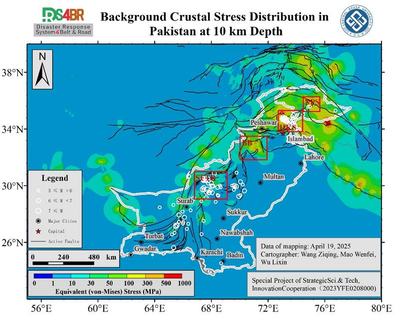
Figure 1. Background Crustal Stress Distribution in Pakistan at 10 km Depth
地应力场动态变化是地震发生的根源,也是地震多圈层多参数异常溯源分析、区域地震隐患排查的重要依据。我们通过三维地质建模与地应力演化模拟,对巴基斯坦区域的地震隐患进行了分析。
研究整合Crust1.0全球地壳模型、多源GPS观测数据及区域地质构造特征,构建了包含断层几何与地层结构的精细化三维有限元模型,通过构造应力演化模拟显示,高应力区与浅层历史地震(≤15km)的空间分布具有显著相关性,基于应力空间分布排查出苏莱曼褶皱带、班努盆地、哈扎拉-克什米尔构造结和南迦-帕尔巴特构造结四个高应力集中区域,并结合各区域地质构造特征进行了地震危险性分析。
以10km深度处的应力分布为例:苏莱曼褶皱带受斜向汇聚作用影响,存在强震复发风险;班努盆地虽有应力积累,但始寒武盐层缓冲了应力释放,地震活动性低;哈扎拉-克什米尔构造结作为印度板块与欧亚板块的碰撞核心区,其西北延伸段受复杂几何构造和隐伏断层控制,应力积累强度高,具备孕育强震的潜势;南迦-帕尔巴特构造结的应力积累中心分布于构造凸起西北角及东侧,尽管当前以中小地震活动为主,但弹性应变能的持续积累可能触发突发性强震。