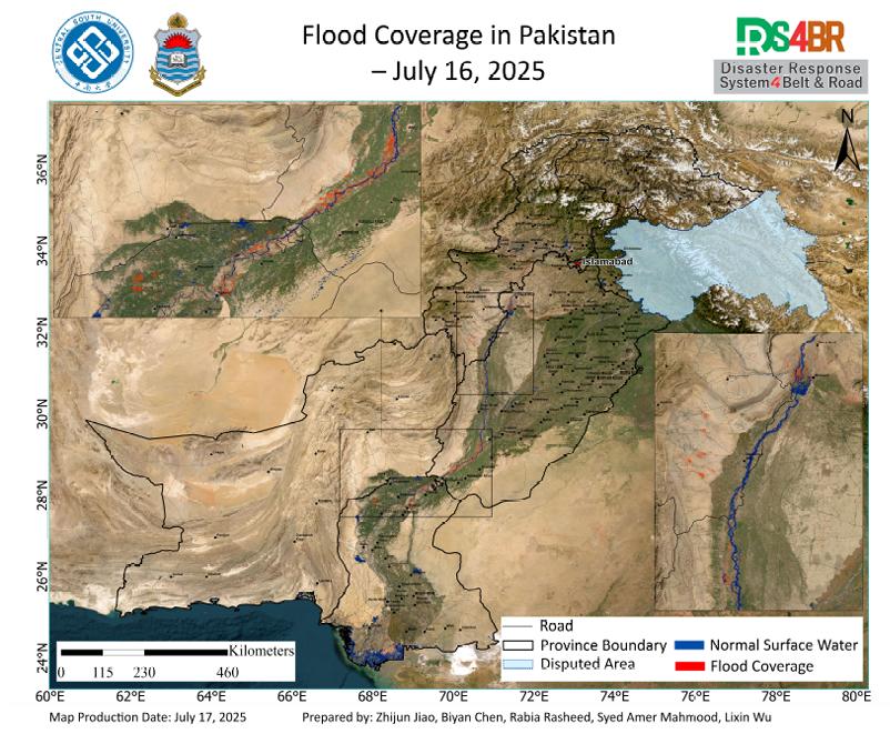
在2025年7月16日的巴基斯坦洪水遥感监测中,基于Sentinel-2、Landsat 8、Landsat-9 与 Sentinel-1 多源遥感影像,结合 KDFIMv2完成了对巴基斯坦全境 洪水淹没情况的综合评估(图1)。监测结果表明,洪水主要集中分布于信德省北 部及旁遮普省南部的印度河流域;这一地区地势相对低平,河网密集,历史上即 为洪水高风险区域。季风期间,来自上游的集中降雨和山区径流通过印度河主干 道向下游汇集,极易导致低洼平原发生广泛淹没。此外,由于该地区农业开发密 集、河道整治能力有限,过量降水还可能导致排涝不畅,进一步加剧内涝风险。
同时,Khyber Pakhtunkhwa(KP)省西南部山区地势起伏较大,降雨径流汇 集速度快,具备典型的山洪易发特征。来自该区域的强径流沿地形向印度河流域 汇入,在河道水位已经较高的背景下,容易触发局地堤防压力增大与小流域溢流, 进而引发次生洪涝扩张现象。
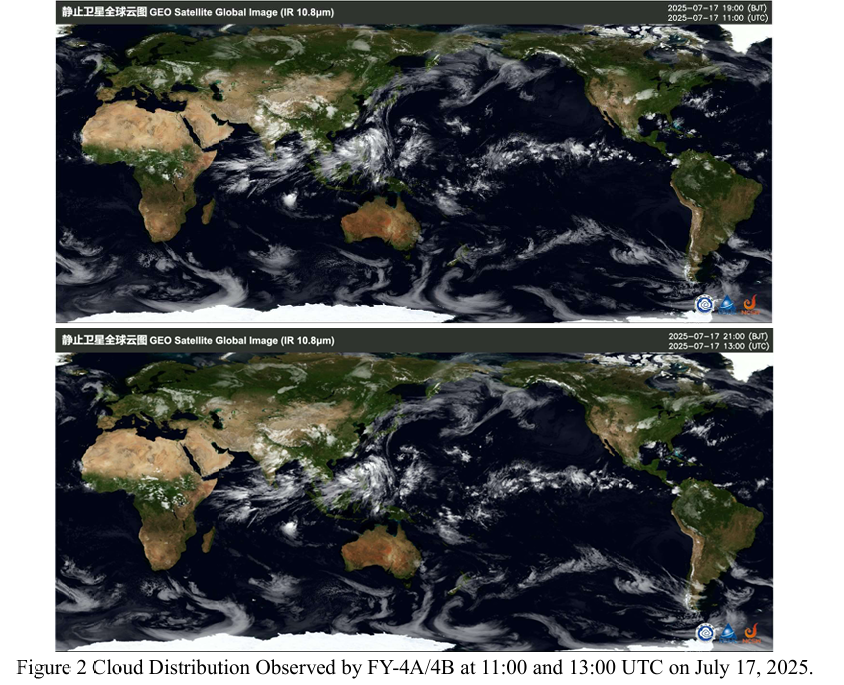
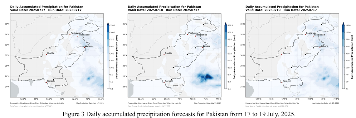
根据2025年7月17日来自FY-4A与FY-4B静止气象卫星的云图资料(图 2)显示,旁遮普省与信德省上空仍有大量水汽聚集,表明当前天气条件依然不 利,持续降雨风险仍然存在。尽管如此,从NCFP GFS全球降水预报模型(图3) 可以看出,未来几天的降水强度整体可能呈减弱趋势,这对区域洪水形势的缓解 具有一定积极意义。不过,鉴于当前天气系统变化仍存在不确定性,预报结果尚 需进一步验证。因此,建议密切关注后续天气演变,以支持救灾工作的动态调整 与灾后响应逐步过渡至恢复阶段。
In the flood remote sensing monitoring on July 16, 2025, a comprehensive assessment of flood inundation across Pakistan was conducted based on multi-source satellite imagery from Sentinel-2, Landsat-8, Landsat-9, and Sentinel-1, combined with the KDFIMv2 algorithm (Fig. 1). The monitoring results indicate that floodwaters were mainly concentrated in the northern Sindh Province and southern Punjab Province within the Indus River Basin. This area features relatively flat topography and a dense river network, making it inherently vulnerable to flood hazards. During the monsoon season, intense upstream rainfall and rapid runoff accumulation converge through the main Indus River channel, increasing the likelihood of large-scale inundation in low-lying regions. Moreover, extensive agricultural development and limited drainage infrastructure in this area contribute to inefficient discharge, further exacerbating both riverine and pluvial flooding risks.
In addition, the southwestern mountainous areas of Khyber Pakhtunkhwa (KP) exhibit complex terrain and steep slopes, where rainfall is quickly transformed into surface runoff— characteristic of flash flood-prone zones. This runoff flows rapidly into the Indus River Basin, and when superimposed on already elevated river levels, it can increase pressure on levees and trigger localized overflow events.
According to cloud imagery from the FY-4A and FY-4B geostationary meteorological satellites on July 17, as shown in Fig. 2, a large amount of atmospheric moisture remains over Punjab and Sindh Provinces, suggesting that weather conditions are still unfavorable and the risk of continued rainfall persists. However, based on precipitation forecasts from the NCFP GFS global model (Fig. 3), rainfall intensity in the coming days is generally expected to decrease, which may help mitigate the flood situation in the region. Nevertheless, given ongoing uncertainties in the evolution of the weather system, the forecast results should be interpreted with caution. Continued monitoring is recommended to support dynamic disaster response planning and the gradual transition toward post flood recovery.