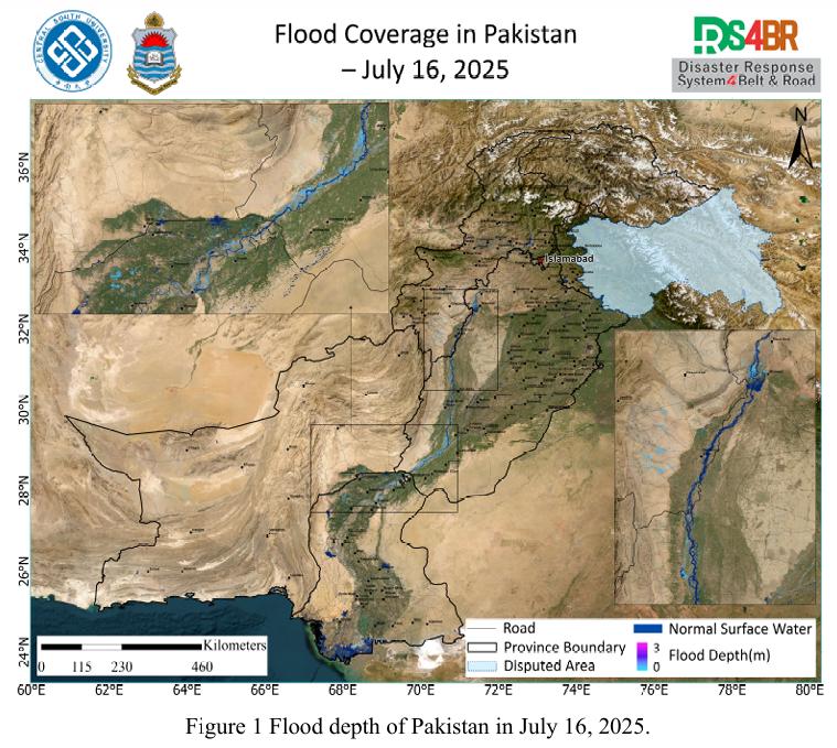
On July 16, 2025, a comprehensive flood depth assessment across Pakistan was conducted using multi-source satellite imagery from Sentinel-1, Sentinel-2, Landsat-8, and Landsat-9, integrated with the KDFIMv2 algorithm (Fig. 1). The results indicate that most inundated areas exhibited flood depths around 1 meter, while floodwaters in the main Indus River channel and the southwestern mountainous region of Khyber Pakhtunkhwa (KP) exceeded 2 meters, highlighting significantly higher flood intensity and risk in these zones.
The southwestern KP region, characterized by steep terrain and rapid runoff convergence, is highly prone to flash flooding. Intense rainfall from this area rapidly drains into the Indus River Basin, and under already elevated river levels, this can lead to increased levee pressure and overflow in smaller catchments—triggering secondary flood expansion events.
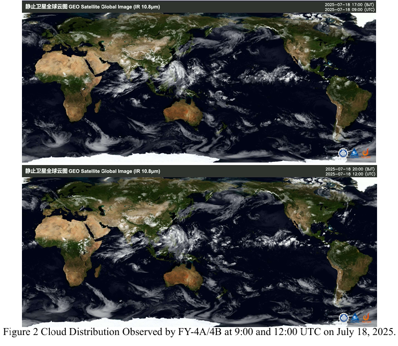
According to the latest cloud imagery from the FY-4A and FY-4B geostationary meteorological satellites at 09:00 and 13:00 UTC on July 18, 2025 (Fig. 2), a significant amount of atmospheric moisture remains over Sindh and Punjab Provinces. This indicates continued instability in regional weather conditions, with potential for further convective development and localized heavy rainfall.
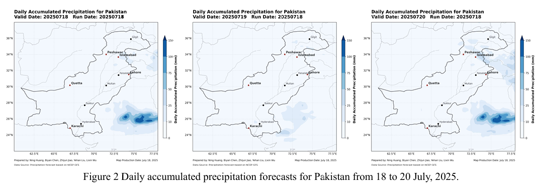
However, precipitation forecasts from the NCFP GFS global model (Fig. 3) show no significant rainfall events expected between July 18 and 20, with an overall weakening trend in rainfall intensity. This may help alleviate the ongoing flood situation and provide a relatively favorable meteorological window for drainage and post disaster recovery operations.
在2025年7月16日的巴基斯坦洪水遥感监测中,基于Sentinel-1、Sentinel 2、Landsat-8 和 Landsat-9 多源遥感影像,并结合KDFIMv2算法,对巴基斯坦全 境的洪水水深分布进行了综合评估(图1)。结果表明,大部分淹没区域的水深在 1 米以下,仅印度河主河道及Khyber Pakhtunkhwa(KP)省西南部山区的洪水水 深超过2米,显示这两个区域面临更高的洪涝强度和风险。
其中,KP省西南部山区地势起伏剧烈、汇流速度快,具典型山洪灾害特征。 该地区的强降雨在短时间内汇入印度河流域,在主河道水位已处于高位的背景下, 容易诱发局地堤防压力上升、小流域溢流等次生洪涝扩展现象。
根据FY-4A 与FY-4B 静止气象卫星在2025年7月18日UTC时间9时与 13 时获取的云图数据(图2),信德省(Sindh)与旁遮普省(Punjab)上空仍有 大量水汽聚集,表明该区域大气层水汽含量维持在高位,天气形势依旧不稳定, 强降水的可能性尚未完全排除。
不过,根据NCFP GFS全球降水预报模型(图3),2025年7月18日至20 日期间,该区域无明显降水过程,整体降水强度呈减弱趋势。这一发展对缓解当 前洪涝形势具有积极意义,也为当地排涝和灾后恢复工作提供了相对有利的气象 窗口。