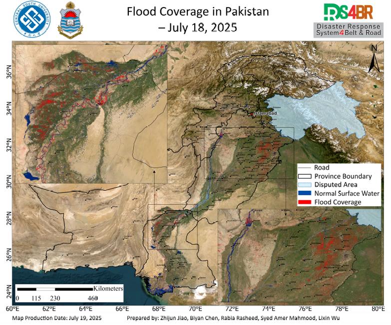
According to the remote sensing monitoring results from July 18, 2025, a comprehensive assessment of flood inundation across Pakistan was conducted using multi-source satellite imagery from Sentinel-1, Sentinel-2, Landsat-8, and Landsat-9 (Fig. 1). The results indicate that flood-affected areas have continued to expand, with significant inundation observed across the Indus River Basin and surrounding regions, particularly in Punjab Province, the Chashma Reservoir area, and parts of Sindh Province.
In Punjab Province, flooding is primarily concentrated in the eastern and northern regions, where extensive areas of agricultural land and residential buildings have been submerged. These areas are characterized by low-lying terrain and dense farming activity, with limited drainage capacity. As a result, widespread waterlogging has occurred, posing a severe threat to local food security and public safety. The inundation patterns show clear spatial continuity and clustering, with potentially deep water accumulation in certain zones.
The flood situation around the Chashma Reservoir remains critical, with no significant reduction in inundated extent, suggesting that water levels in this area are still persistently high. Additionally, portions of Sindh Province have begun to experience agricultural flooding, indicating a downstream propagation of flood impact along the Indus River system. Remote sensing imagery also shows a marked expansion in surface water extent along the main Indus River channel, consistent with seasonal high flows. Continued rainfall or additional upstream inflows may trigger more extensive flooding in the coming days.
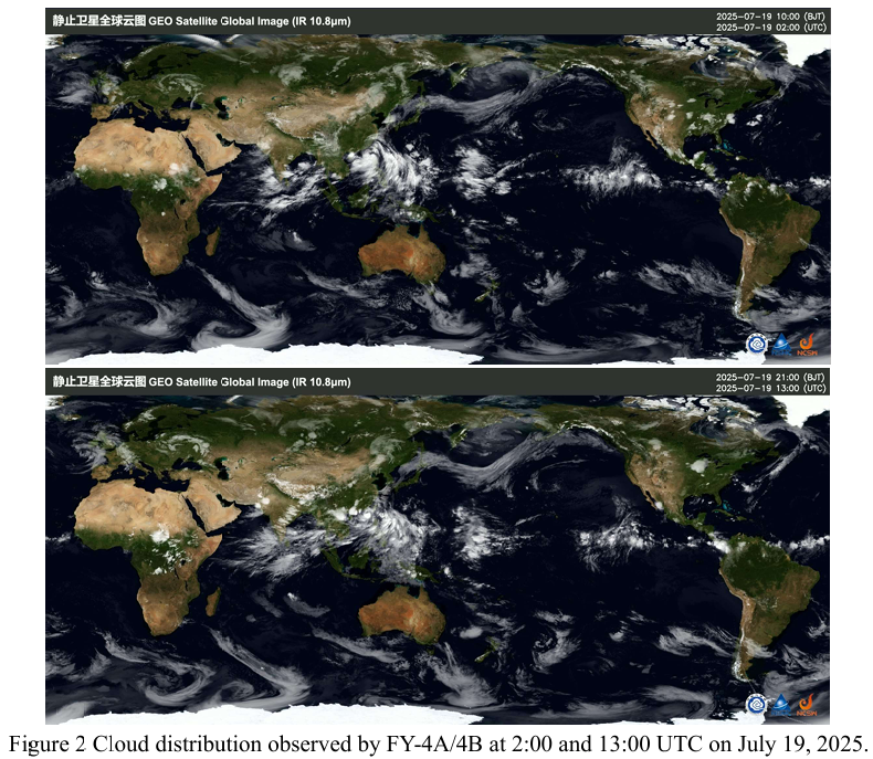
According to cloud imagery obtained by the FY-4A and FY-4B geostationary meteorological satellites at 02:00 and 13:00 UTC on July 19, 2025 (Fig. 2), although clear skies were observed over Sindh Province at 02:00 UTC, new mid- to high-level cloud systems redeveloped over the region by 13:00 UTC. This indicates that atmospheric water vapor remains abundant, and the convective activity is still active. The atmospheric conditions are unstable, and the risk of localized heavy rainfall cannot be fully ruled out.
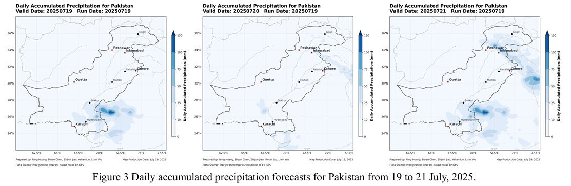
Meanwhile, according to the forecast output from the NCFP GFS global precipitation model (Fig. 3), rainfall across most parts of Pakistan is expected to remain generally weak during July 19–21, 2025, with a decreasing trend in precipitation intensity. However, model outputs suggest that by July 21, a new round of significant rainfall may affect the northern mountainous areas of Islamabad and Peshawar, raising concerns about localized heavy precipitation events. Given the inherent uncertainties of numerical weather prediction models, these forecasts should be interpreted with caution and integrated with real-time observations from FY-4A/4B and other multi source remote sensing and ground-based monitoring systems for dynamic assessment.
根据2025年7月18日的遥感监测结果,基于Sentinel-1、Sentinel-2、Landsat 8 和Landsat-9 多源遥感影像,对巴基斯坦全境的洪水淹没分布进行了综合评估 (图1)。结果显示,洪涝影响范围持续扩大,印度河流域及其周边多个区域出现显著淹没,特别是旁遮普省、Chashma 水库区域以及信德省部分地区受灾严重。
在旁遮普省,洪水主要集中于东部和北部地区,大量农田与居民房屋被洪水淹没。这些区域地势较低,农业密集,洪水来袭后排涝能力不足,形成大面积积 水,严重威胁当地粮食安全和居民生命财产安全。淹没区域显示出明显的连续性和集中性,部分地区积水深度预计较高。
Chashma 水库周边地区的洪水淹没情况依旧严峻,积水范围未见明显缩减, 表明该区域的水体仍处于高位运行状态。此外,信德省部分地区也开始出现农田 积水,洪水影响正在向印度河下游蔓延。遥感影像同时显示,印度河干流沿线水体范围明显扩大,表明当前正处于季节性涨水阶段,若后续降雨持续或上游来水 增加,可能引发更大范围的洪涝灾害。
根据FY-4A 与FY-4B 静止气象卫星于2025年7月19日UTC时间2时与13 时获取的云图数据(图2)显示,尽管2时信德省(Sindh)上空短暂出现晴空,但至13时新一轮中高层云系再次在该区域聚集,表明该地区大气水汽仍处于高位。区域对流活跃,天气系统不稳定,短时强降水的可能性依然存在,需持续监测。
同时,根据NCFP GFS全球降水预报模型输出结果(图3),2025年7月19 日至21日期间,巴基斯坦大部地区预期降水总体较弱,降水强度呈减弱趋势。然而,数值预报显示,至7月21日,伊斯兰堡及白沙瓦以北山区可能迎来新一 轮较为显著的降雨过程,局地短时强降水风险需引起关注。鉴于数值模式本身存在一定不确定性,相关预报应结合FY-4A/4B等多源遥感观测资料与地面监测信息进行动态综合研判。