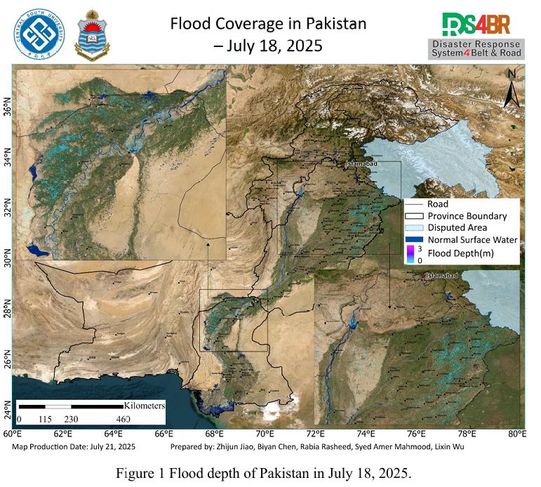
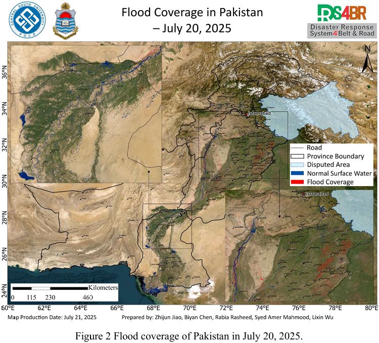
Based on remote sensing observations from July 18 to 20, 2025, a comprehensive flood assessment was conducted over Pakistan by integrating multi-source satellite imagery from Sentinel-1, Sentinel-2, Landsat-8, and Landsat-9, and applying the KDFIMv2 algorithm for enhanced spatial flood analysis. The assessment focused on flood water depth (Fig. 1) and inundation extent (Fig. 2).
The flood water depth mapping on July 18, 2025 revealed that average inundation depth across Punjab and Sindh provinces remained below 1 meter, primarily affecting intensively cultivated agricultural regions, thus posing substantial threats to crop production. Notably, the flood expansion in the Chashma Reservoir area and the upper and lower reaches of the Indus River was pronounced. Although inundated areas expanded significantly, the water depth remained under 2 meters, indicating widespread shallow waterlogging with a high risk of sustained flooding and potential agricultural damage.
The flood extent derived from July 20, 2025 imagery showed no noticeable reduction in inundated areas in Punjab, where observation conditions were favorable. In some regions, flood extent even increased, especially downstream of the Chashma Reservoir along the Indus River mainstem, highlighting active flood propagation. In Sindh Province, although cloud interference limited satellite observations, distinct flood signals were still evident in the upstream Indus Basin, indicating ongoing downstream flood migration and the necessity of continuous monitoring and early warning measures.
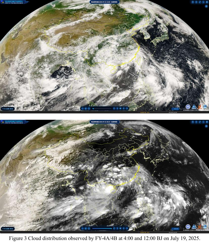
On July 21, 2025, the latest cloud imagery acquired by the FY-4B geostationary meteorological satellite (Fig. 3) indicates that at 04:00 UTC, parts of Pakistan experienced a brief period of clear skies. However, by 12:00 UTC, moisture-laden cloud bands had once again covered the entire country, indicating a highly unstable atmospheric structure with intense regional convection and a significantly increased risk of short-duration heavy rainfall. After 12:00 UTC and into the nighttime, there is a heightened risk of heavy rainfall events, which may lead to severe flood hazards.
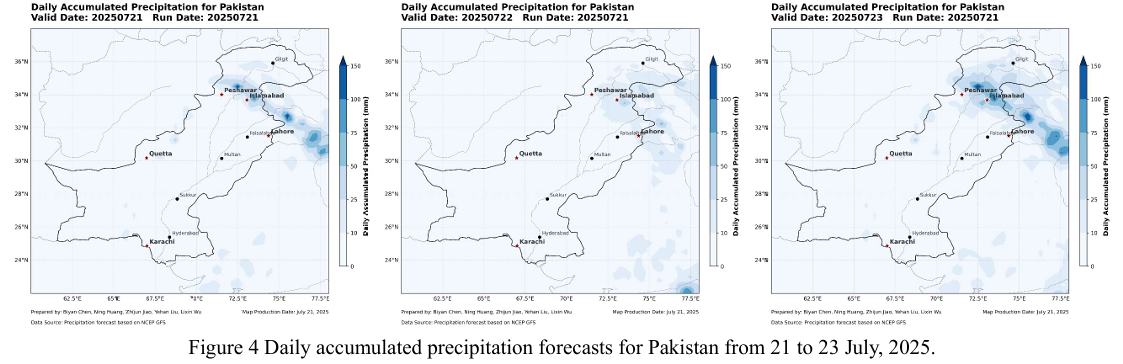
Precipitation forecasts from the NCFP GFS global model (Fig. 4) indicate a significant rainfall event is expected over northern Pakistan, particularly northern Punjab, between July 21 and 23. Given the already saturated soil conditions and residual floodwaters, this additional rainfall is likely to trigger a new wave of flooding, along with increased risk of secondary disasters such as landslides, debris flows, and flash floods. Proactive early warning dissemination and disaster preparedness should be prioritized across vulnerable regions.
根据2025年7月18日至20日的遥感监测结果,结合Sentinel-1、Sentinel 2、Landsat-8 和 Landsat-9 多源光学与雷达遥感影像,并采用KDFIMv2算法,对巴基斯坦全境的洪水水深(图1)与淹没分布(图2)进行了综合分析与动态评估。
2025 年7月18日的洪水水深反演结果表明,旁遮普省与信德省的洪涝淹没 区域平均水深普遍低于1米,主要分布于农业用地密集区,洪涝对农作物造成较大威胁。值得注意的是,Chashma 水库及其上下游的印度河流域洪水扩展明显,尽管淹没面积持续扩大,但水深整体控制在2米以内,呈现出典型的浅层广泛积水特征,指示该区域面临持续淹没和农田次生灾害的高风险。
2025 年7月20日的洪水淹没范围提取结果显示,在遥感观测条件良好的旁遮普省,洪水淹没范围与18日相比无明显减退,局地甚至有所扩张,尤其是在 Chashma 水库下游沿印度河干流区域,淹没扩张趋势最为显著。尽管信德省因云 层遮蔽等观测条件限制,结果不甚完整,但其上游区域仍可见较为清晰的洪水扩张迹象,说明洪水正持续向下游推进,该区域需重点监测与动态风险评估。
2025 年 7 月21日,FY-4B静止气象卫星获取的最新云图数据显示(图3),当日UTC时间04时,巴基斯坦部分地区短暂出现晴朗天气。但至12时,水汽云带再次覆盖全国,表明大气层结构高度不稳定,区域对流强烈,短时强降水风 险显著增加。12 时以后进入夜间,应高度警惕暴雨来袭,可能引发严重洪涝灾害。
结合NCFP GFS全球降水预报模型(图4)的输出结果,预计2025年7月 21 日至23日,巴基斯坦北部,尤其是旁遮普省北部地区,将面临新一轮显著降水过程。考虑到当前洪水尚未退去,该轮降雨极有可能触发新一轮洪涝灾害,并 进一步诱发滑坡、泥石流及山洪等次生地质灾害,亟需加强区域联动监测、滚动 预警发布及灾前应急准备。