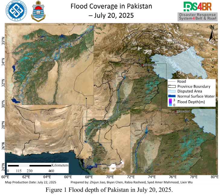
Based on remote sensing monitoring results from July 20 to 21, 2025, a comprehensive analysis and dynamic assessment of flood water depth (Fig. 1) and inundation extent (Fig. 2) across Pakistan was conducted. This analysis utilized multi source optical and radar satellite imagery from Sentinel-1, Sentinel-2, Landsat-8, and Landsat-9, in combination with the KDFIMv2 algorithm.
The flood water depth retrieval on July 20, 2025 (Fig. 1), indicates that most inundated areas exhibited relatively shallow water depths, generally below 1 meter. These areas are mainly distributed across agriculturally intensive regions in Sindh and Punjab provinces. Compared with previous observations, the seasonal rise of the Indus River has entered a relatively stable phase, with no significant further expansion. The floodwaters demonstrate persistent but slow-changing shallow inundation characteristics.
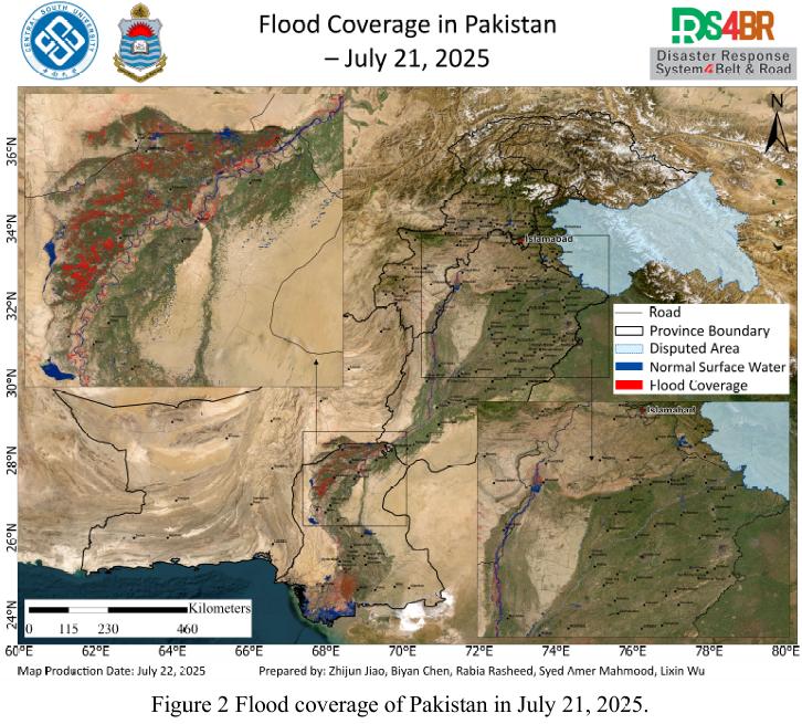
On July 21, 2025, the extracted flood inundation extent (Fig. 2) was limited in spatial coverage due to observation constraints, with valid data primarily available for Sindh Province and the northern Indus River basin. Compared with the conditions on July 20, a partial recession of floodwaters was detected in northern Sindh's agricultural fields, while new inundation areas appeared in the south. Meanwhile, the surface water area within the Indus River channel remained stable, suggesting that current flooding is largely contained within the river system and has not yet resulted in widespread overbank flooding.
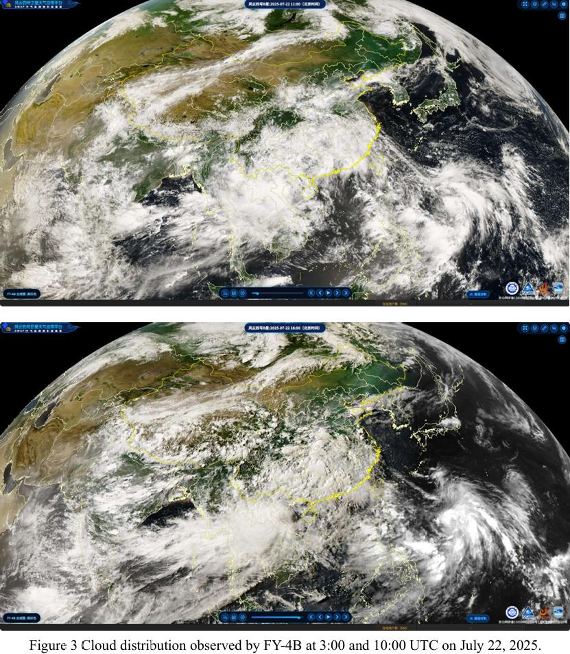
On July 22, 2025, FY-4B geostationary meteorological satellite imagery (Fig. 3) showed that at 03:00 and 10:00 UTC, most of southern Pakistan experienced clear weather, providing favorable conditions for optical remote sensing-based flood monitoring. However, persistent and unstable cloud cover was observed over the northern mountainous regions, indicating active convection and significant atmospheric instability—factors that may trigger localized intense rainfall.
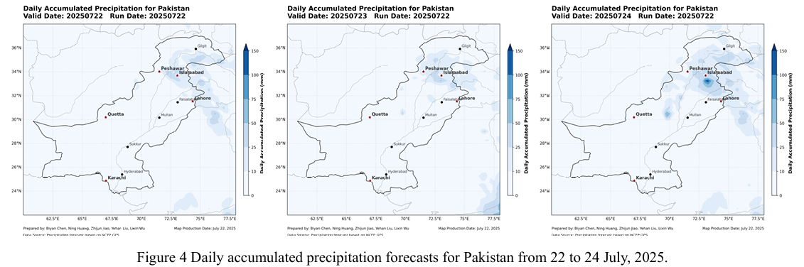
According to the NCFP GFS global precipitation forecast model (Fig. 4), a new round of significant rainfall is expected between July 22 and 24, particularly affecting northern Punjab and parts of the mountainous region of Khyber Pakhtunkhwa (KP). Given that floodwaters have not yet fully receded, the upcoming precipitation event could intensify ongoing flooding and further trigger secondary geo-hazards such as landslides, debris flows, and flash floods. As such, it is critical to enhance integrated regional monitoring using multi-source data, strengthen rolling early warning dissemination, and ensure coordinated emergency preparedness in high-risk areas.
根据2025年7月20日至21日的遥感监测结果,结合Sentinel-1、Sentinel 2、Landsat-8 和 Landsat-9 多源光学与雷达遥感影像,并采用KDFIMv2算法,对巴基斯坦全境的洪水水深(图1)与淹没分布(图2)进行了综合分析与动态评估。
2025 年 7 月20日的洪水水深反演结果(图1)显示,大部分淹没区域的水 深较浅,普遍未超过1米,主要集中在农业用地密集的信德省与旁遮普省。与前期结果对比,印度河流域的季节性涨水进入相对平稳阶段,洪水未出现明显扩张, 表现为浅层积水范围维持但动态变化缓慢的态势。
2025 年 7 月21日的洪水淹没范围提取结果(图2)受观测条件影响,仅在 信德省及印度河北部流域区域有效获取。从淹没变化趋势来看,相较于20日,信德省北部农田中部分积水区域已出现明显退水迹象,而南部则监测到新增积水 范围。同时,印度河河道水域面积整体保持稳定,表明洪水主要仍受河道约束, 尚未形成大规模泛滥态势。
2025 年 7 月22日,FY-4B静止气象卫星获取的云图数据(图3)显示,当日UTC时间03时与10时,巴基斯坦南部大部地区天气转晴,有利于遥感观测 获取洪涝信息。但在北部山区,云层覆盖持续并呈现出显著的不稳定特征,反映出区域对流活动频繁,大气层结构动荡,预示未来短时强降水可能性升高。
结合NCFP GFS全球降水预报模型(图4)结果,预计2025年7月22日至 24 日,旁遮普省北部及Khyber Pakhtunkhwa(KP)山区将出现新一轮显著降水过程。在当前洪水尚未完全消退的背景下,此轮降水极有可能加剧现有洪涝灾情,并可能诱发滑坡、泥石流和山洪等次生地质灾害。因此,亟需加强重点区域的多源数据融合监测、滚动风险预警发布以及区域协同防灾应对措施。