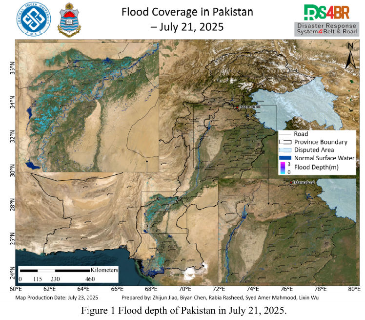
Based on the optical and radar remote sensing imagery from Sentinel-1, Sentinel 2, Landsat-8, and Landsat-9 acquired between July 21 and 22, 2025, floodwater depth (Fig. 1) and inundation extent (Fig. 2) across Pakistan were dynamically evaluated and comprehensively analyzed using the KDFIMv2 algorithm. Relevant meteorological changes and future risk trends were assessed based on FY-4B geostationary satellite cloud imagery (Fig. 3) and the NCFP GFS global precipitation forecast model (Fig. 4).
Fig. 1 presents the distribution of floodwater depth on July 21, 2025. Monitoring results show widespread shallow surface water in the agricultural areas of Sindh Province; although water depths are generally low, the inundated area remains extensive. In Punjab Province, flood extent has eased to some degree, with overall shallow water depth. The water surface area and depth along the Indus River remain stable with no significant expansion trend, indicating that the flooding remains largely confined within the river channels.
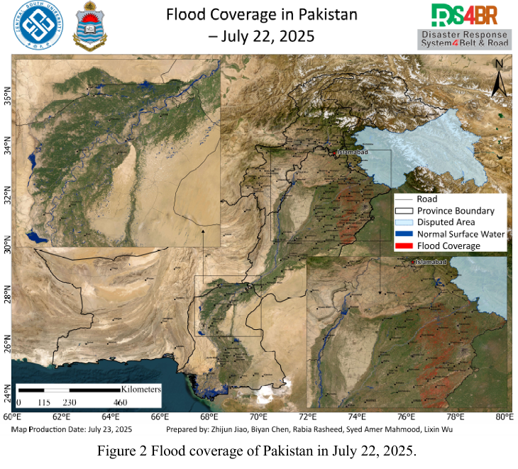
Fig. 2 shows the flood inundation extent on July 22, 2025. Due to satellite observation limitations, valid data was only available for the Punjab region. Compared with the flood extent on the previous day, a notable reduction in inundated areas was observed in Punjab, suggesting that the flood situation has alleviated to some extent.
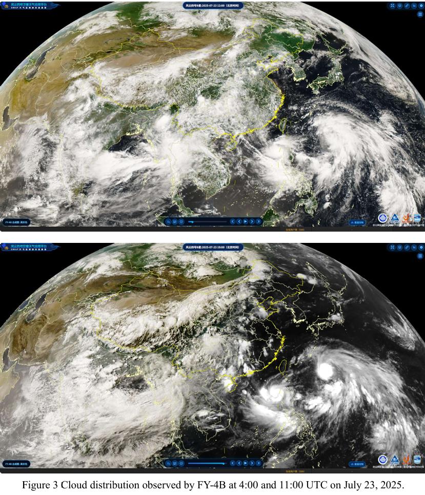
Fig. 3 presents infrared cloud imagery captured by the FY-4B geostationary meteorological satellite on July 23, 2025. Between UTC 04:00 and 11:00, dense cloud cover was observed over northern Pakistan, which gradually dissipated. However, new cloud systems began to gather over Khyber Pakhtunkhwa (KP) and Gilgit-Baltistan (GB), indicating continued convective activity in the region. This suggests a heightened risk of short-term heavy rainfall and associated flash flooding.
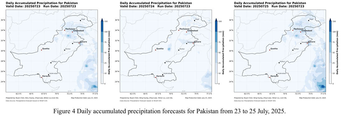
Fig. 4 shows precipitation forecasts from the NCFP GFS model for the next two days (July 23–24). Northern Pakistan, especially KP and the surrounding mountainous areas, is expected to experience continued rainfall. Considering the previous floods have not yet fully receded, the upcoming precipitation is highly likely to exacerbate the current flood situation and may trigger secondary disasters such as landslides, debris flows, and flash floods.
根据2025年7月21日至22日的Sentinel-1、Sentinel-2、Landsat-8与Landsat 9 等光学与雷达遥感影像观测结果,采用KDFIMv2算法,对巴基斯坦境内的洪 水水深(图1)与淹没范围(图2)进行了动态评估与综合分析。相关气象变化 与未来风险趋势参考FY-4B静止气象卫星云图(图3)及NCFP GFS全球降水预报模型(图4)。
图1所示为2025年7月21日的洪水水深分布结果。监测表明,信德省农田区域普遍存在浅层积水,水深虽不大,但积水范围依然较广;而旁遮普省的淹没范围则有所缓解,水深总体不深。印度河河道沿线的水域面积及水深分布整体保持平稳,无明显扩张趋势,说明洪水大体仍处于河道控制范围内。
图2展示了2025年7月22日的洪水淹没分布情况,由于受卫星观测条件限制,只有旁遮普省区域具备有效数据。与前期洪水淹没分布对比来看,旁遮普省积水区域已出现明显减退,洪水形势较前期有所缓和。
图3为FY-4B静止气象卫星在2025年7月23日获取的红外云图,显示UTC 时间 4 时至 11 时,巴基斯坦北部地区云层较为密集,随后逐渐消散。然而在 Khyber Pakhtunkhwa(KP)和 Gilgit-Baltistan(GB)周边区域,新的云系再次聚集,表明该地区对流活动仍较活跃,短时强降水及其引发的山洪风险仍需高度关 注。
图4基于NCFP GFS模型的降水预测结果显示,未来两天(7月23日至24 日),巴基斯坦北部地区仍将面临持续降雨过程,特别是在 KP 及其北部山区。考虑到前期洪水尚未完全消退,后续降雨极可能加剧当前灾情,并诱发滑坡、泥石流和山洪等次生灾害。