标题:UN report maps trail of monsoon havoc 时间:2025-7-20 正文: LAHORE:The United Nations has highlighted the damages caused by monsoon rains in Pakistan that led authorities to declare disaster zones across parts of Punjab where lethal cloudbursts and flash floods killed dozens in a single day.In a report published on its website, the UN said the unfolding crisis – rising rivers, foreca...
Details
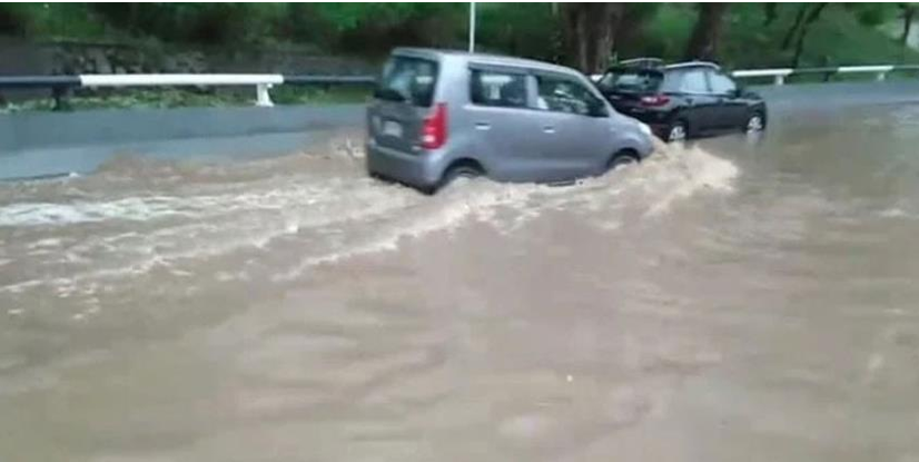
标题:At least 70 dead in 48 hours as monsoon rains lash Punjab时间:2025-7-19 18:14:00正文:LAHORE:At least 70 people died in the past 48 hours as relentless monsoon rains continue to wreak havoc across Punjab, raising the provincial death toll to 123 since late June, Express News reported. The Provincial Disaster Management Authority (PDMA) confirmed widespread damage due to roof collapses...
Details
标题:PDMA warns of possible Indus flooding at Kalabagh, Chashma时间:2025-7-18正文:Punjab’s Provincial Disaster Management Authority (PDMA) on Friday issued a high flood warning for the Indus River at Kalabagh and Chashma, following the province’s deadliest day of the ongoing monsoon season a day earlier, which claimed at least 63 lives amid widespread urban and riverine flooding.The Flood F...
Details
标题:Punjab declares emergency as torrential rains kill 103, injure 393 时间:2025-7-17 正文:At least 103 people have lost their lives and 393 have been injured during the ongoing monsoon season in Punjab, according to a comprehensive report released by the Provincial Disaster Management Authority (PDMA).The report outlines both human and material losses caused by the relentless monsoon rai...
Details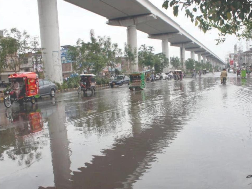
标题:At least 12 killed, six injured in Lahore as rain lashes city 时间:2025-7-16 18:57:00 正文:At least 12 people were killed and six others injured in three separate roof collapse incidents in Lahore overnight, emergency officials said on Wednesday.Rescue 1122 teams responded to calls from Muridwal village, Mission Colony on Raiwind Road, and Kot Jamal early Wednesday morning. The collap...
Details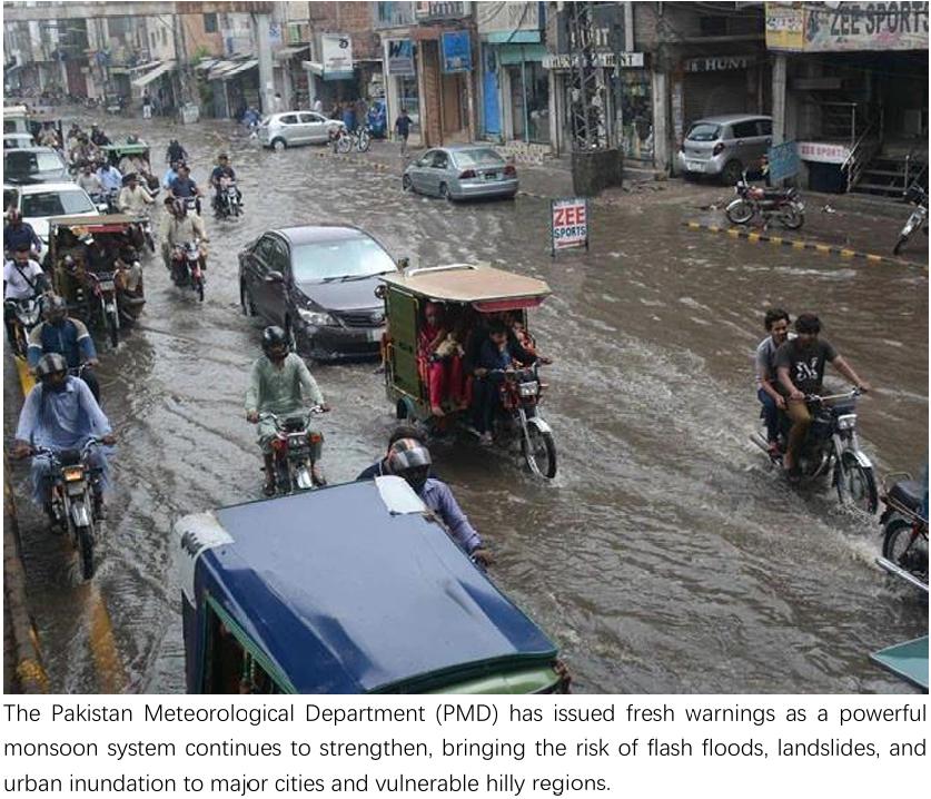
标题:Monsoon system strengthens as rain sweeps through major cities 时间:2025-7-15 正文:The Pakistan Meteorological Department (PMD) has issued fresh warnings as a powerful monsoon system continues to strengthen, bringing the risk of flash floods, landslides, and urban inundation to major cities and vulnerable hilly regions.The alert, issued on Tuesday morning, spans from the northern distri...
Details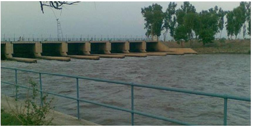
标题:Punjab PDMA issues flood alert amid rising Indus River levels 时间:2025-7-14 正文:LAHORE: The Provincial Disaster Management Authority (PDMA) Punjab Monday issued a flood alert for the Taunsa Barrage on the Indus River amid rising water levels.According to a PDMA spokesperson, a moderate flood situation has developed at the barrage, where water discharge has reached 418,000 cusecs, with...
Details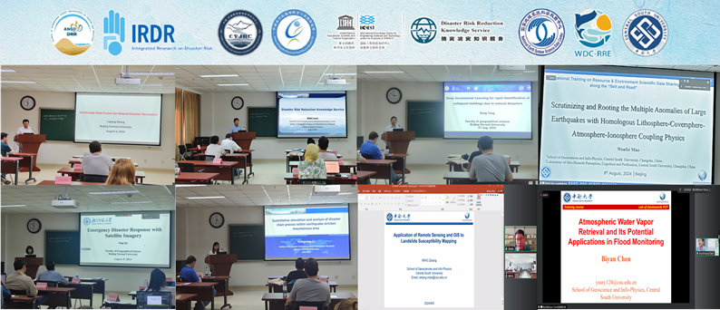
The International Training Workshop on Resource & Environment Scientific Data Sharing along the“Belt and Road”successfully held at the Institute of Geographic Sciences and Natural Resources Research, Chinese Academy of Sciences (IGSNRR, CAS) from July 28th to August 11th, 2024. The training workshop attracted 70 applicants from 15 countries along the Belt and Road. Ultimately, 20 participants...
Details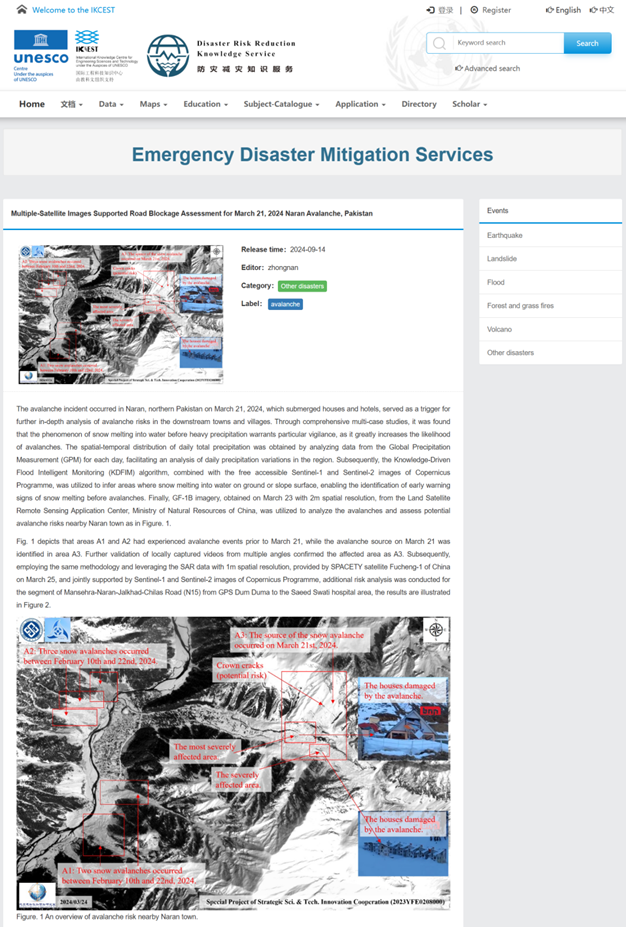
Relying on the Disaster Risk Reduction Knowledge Service platform of International Knowledge Centre for Engineering Sciences and Technology under the Auspices of UNESCO (IKCEST-DRR) (website: https://ikcest-drr.data.ac.cn/zn/), an Emergency Disaster Mitigation Services column has been established. It has released emergency relief service information for three natural disasters: the Naran Avalan...
Details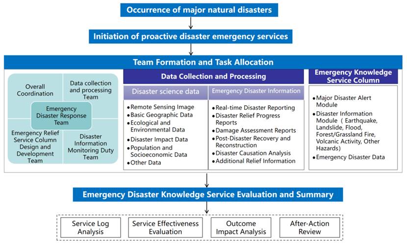
"Disaster Emergency Knowledge Service Specification" establishes a systematic framework for standardized emergency response operations, providing scientific guidance throughout the entire lifecycle of proactive disaster knowledge services - from rapid activation and standardized implementation to comprehensive evaluation and continuous improvement.This Specification specifies the core componen...
Details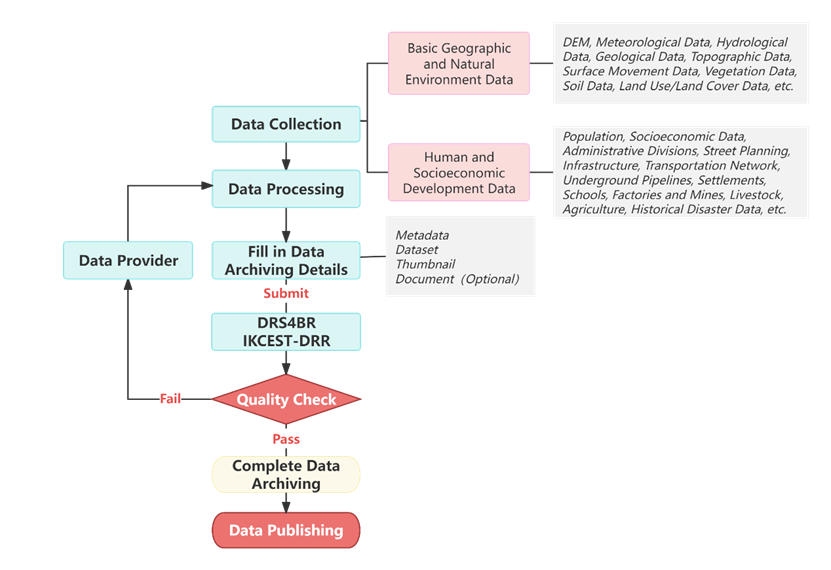
Formulation of a data transfer specification for the "Developing Satellite Emergency-Response System and Using for Typical Major Natural Hazards Project (2023YFE0208000)". The purpose of the specification is to promote the orderly management of project data exchange, improve data quality and efficient sharing, and promote the emergency response to major natural disasters and the wide applicatio...
Details
At the project team level, a study on the establishment of an international cooperation mechanism between China and Pakistan for emergency response and disaster data sharing has been carried out. This cooperation mechanism encompasses multidimensional collaboration in the fields of disaster data sharing and disaster risk response, including joint scientific research projects, capacity building,...
Details
DRS4BR system mainly serves the monitoring, early warning, disaster reduction and rescue work of typical geological disasters such as earthquakes, volcanoes, landslides, floods and forest fires in countries/regions along the Belt and Road. The system uses a microservice architecture to implement containerized deployment, service orchestration, dynamic scheduling and other functions. It integrat...
Details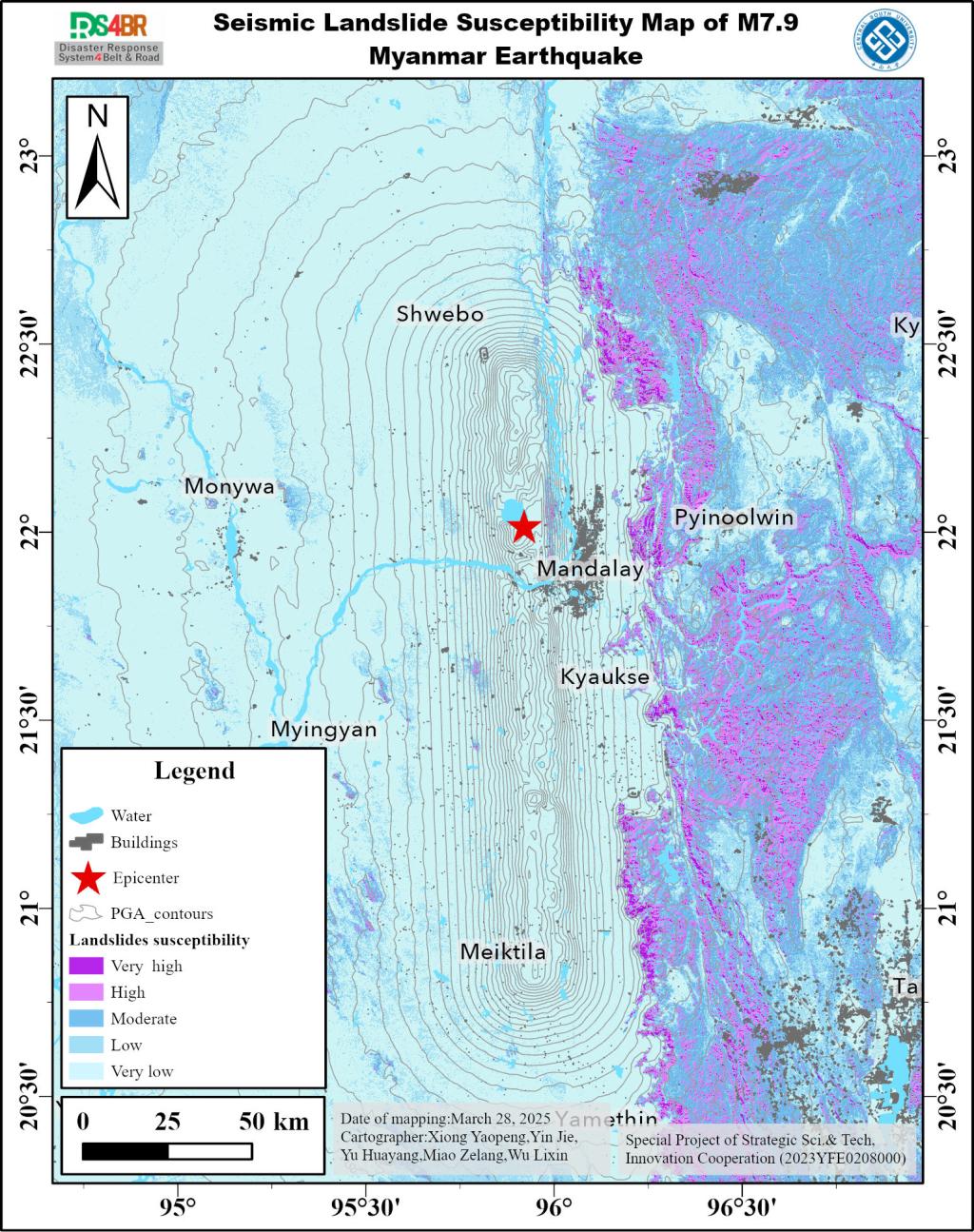
On March 28, 2025, a significant Mw7.9 earthquake struck near Mandalay in central Myanmar, posing risks of coseismic landslides in the affected areas. We evaluated landslide susceptibility by integrating multi-source geological, topographic, and hydrological data with the Newmark permanent displacement model. The model quantifies slope displacement through the integral of the difference between...
Details
The avalanche incident occurred in Naran, northern Pakistan on March 21, 2024, which submerged houses and hotels, served as a trigger for further in-depth analysis of avalanche risks in the downstream towns and villages. Through comprehensive multi-case studies, it was found that the phenomenon of snow melting into water before heavy precipitation warrants particular vigilance, as it greatly in...
Details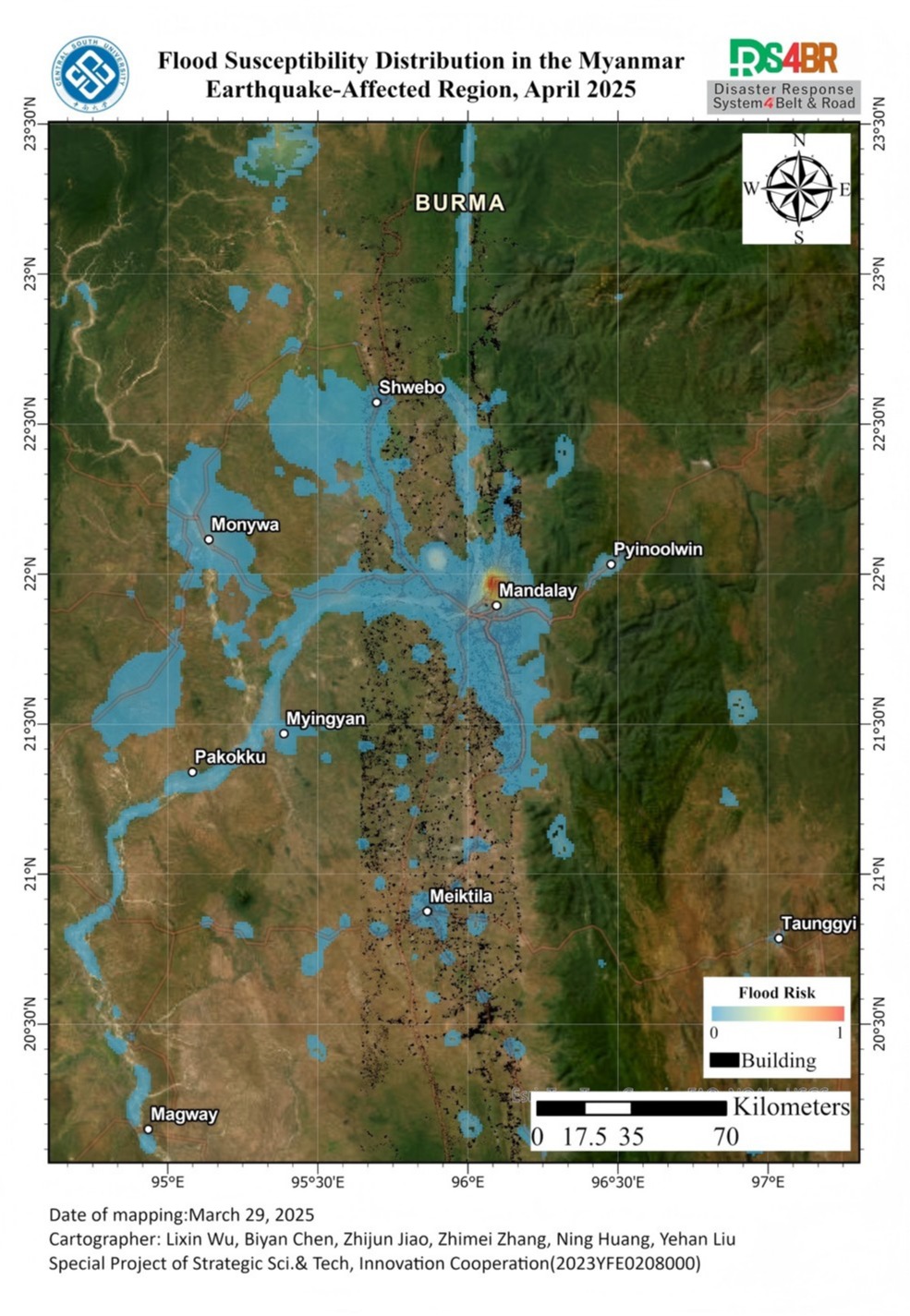
The Mw 7.9 earthquake that struck Myanmar's Sagaing Region on March 28, 2025, caused severe structural damage and increased the potential for secondary hazards, particularly flooding. Ground deformation, soil liquefaction, and disrupted drainage systems may exacerbate the risk of post-earthquake flooding, posing significant threats to affected communities and complicating emergency response efforts. Given the potential interplay between seismic and flood hazards, timely flood risk monitoring is crucial to mitigate further casualties and damage.
DetailsCopyright © 2025. DRS4BR All rights reserved.