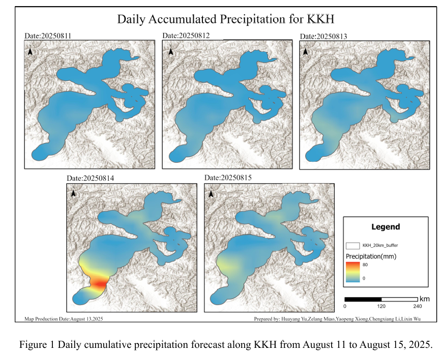
Combined with the precipitation forecast based on the NCFP GFS model onAugust 13, 2025, and multi-source data such as lithology, DEM, and hydrological conditions along the Karakoram Highway, the TRIGRS model was adopted to conduct landslide risk assessment in the northern area that was greatly affected by rainfall. The NCEP GFS precipitation forecast shows that on August 13, the overall rai...
Details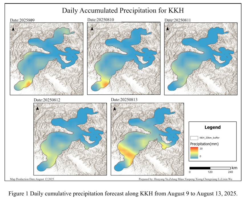
Combined with the precipitation forecast based on the NCFP GFS model onAugust 12, 2025, and multi-source data such as lithology, DEM, and hydrological conditions along the Karakoram Highway, the TRIGRS model was adopted to conduct landslide risk assessment in the northern area that was greatly affected by rainfall. The NCEP GFS precipitation forecast shows that on August 12, the overall rai...
Details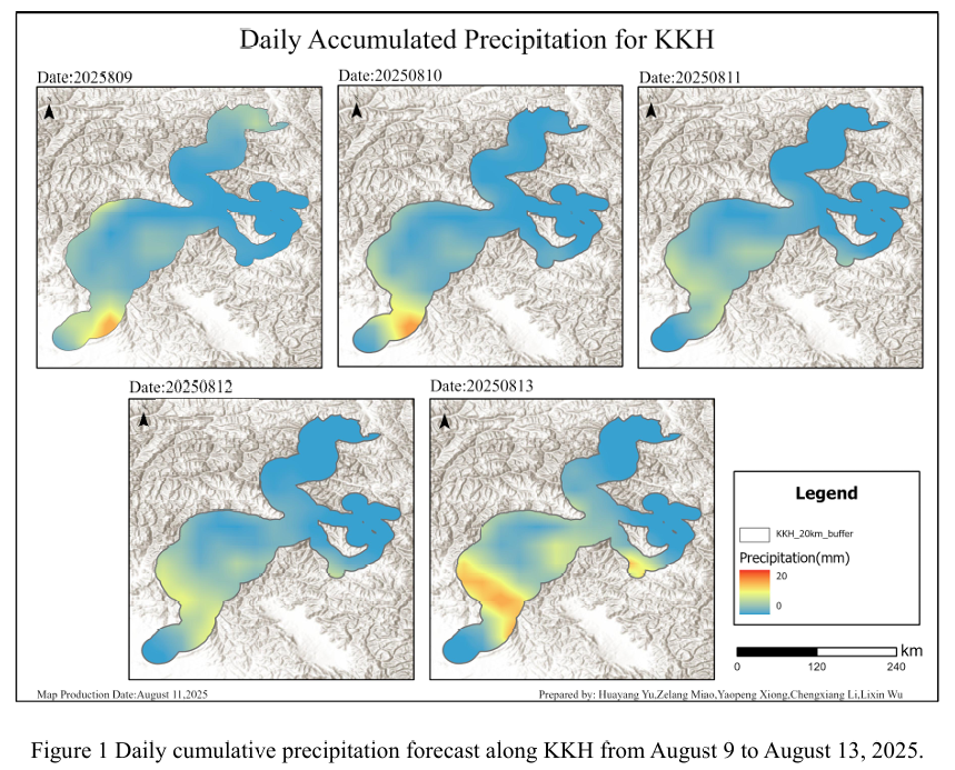
Combined with the precipitation forecast based on the NCFP GFS model onAugust 11, 2025, and multi-source data such as lithology, DEM, and hydrological conditions along the Karakoram Highway, the TRIGRS model was adopted to conduct landslide risk assessment in the northern area that was greatly affected by rainfall. The NCEP GFS precipitation forecast shows that on August 11, the overall rai...
Details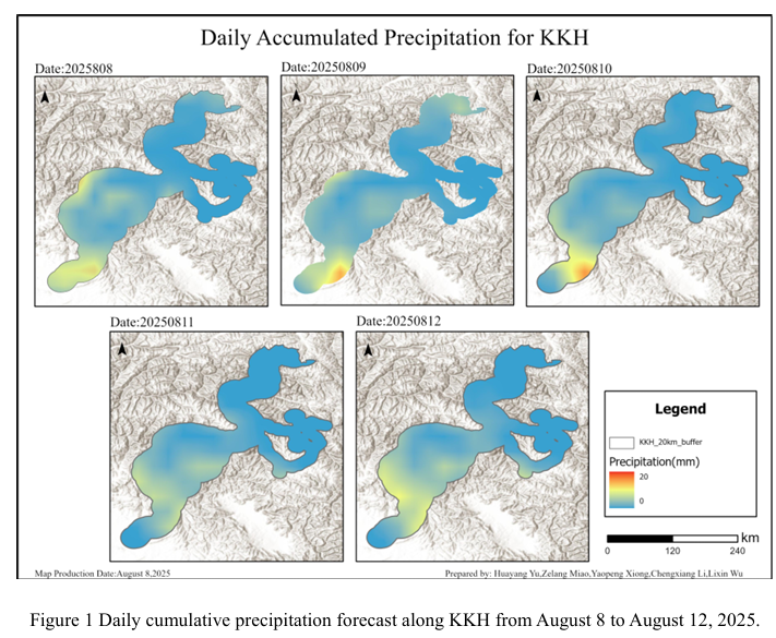
Combined with the precipitation forecast based on the NCFP GFS model onAugust 10, 2025, and multi-source data such as lithology, DEM, and hydrological conditions along the Karakoram Highway, the TRIGRS model was adopted to conduct landslide risk assessment in the northern area that was greatly affected by rainfall. The NCEP GFS precipitation forecast shows that on August 10, the overall rai...
Details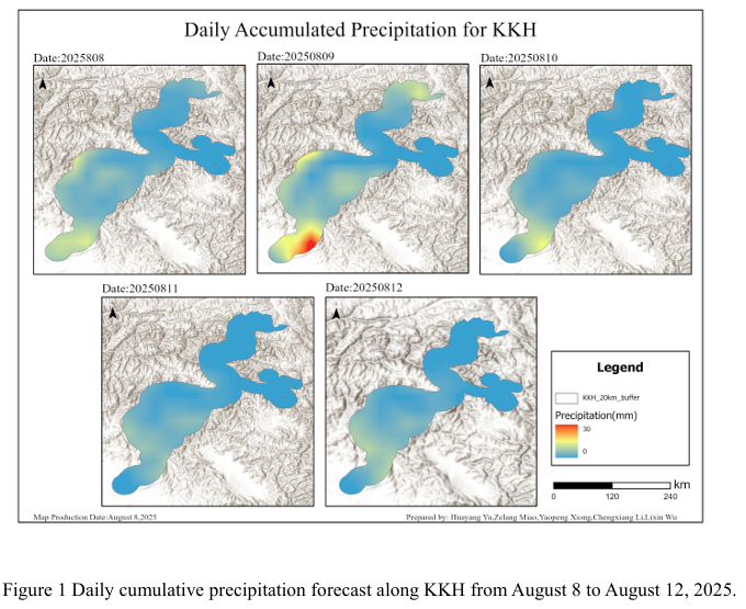
Combined with the precipitation forecast based on the NCFP GFS model on August 9, 2025, and multi-source data such as lithology, DEM, and hydrological conditions along the Karakoram Highway, the TRIGRS model was adopted to conduct landslide risk assessment in the northern area that was greatly affected by rainfall. The NCEP GFS precipitation forecast shows that on August 9th, the overall ra...
Details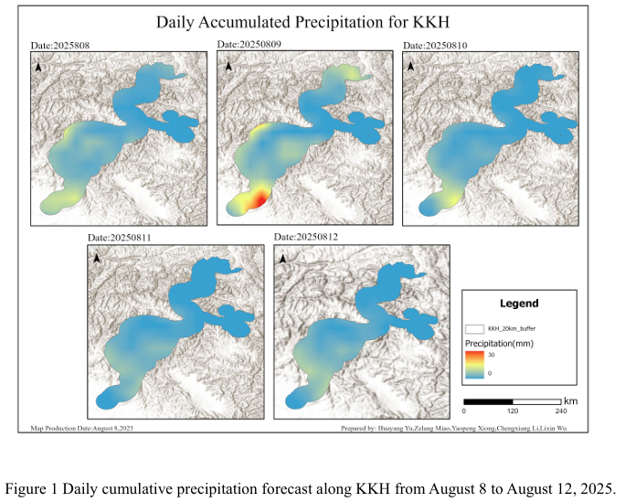
Combined with the precipitation forecast based on the NCFP GFS model on August 8, 2025 and multi-source data such as lithology, DEM and hydrological conditions along the Karakoram Highway, the TRIGRS model was adopted to conduct the landslide risk assessment in the northern area that was greatly affected by rainfall. The NCEP GFS precipitation forecast shows that on August 8th, the overall ...
Details
Combined with the precipitation forecast based on the NCFP GFS model on August 7, 2025 and multi-source data such as lithology, DEM and hydrological conditions along the Karakoram Highway, the TRIGRS model was adopted to conduct the landslide risk assessment in the northern area that was greatly affected by rainfall. The NCEP GFS precipitation forecast shows that on August 7th, the overall ...
Details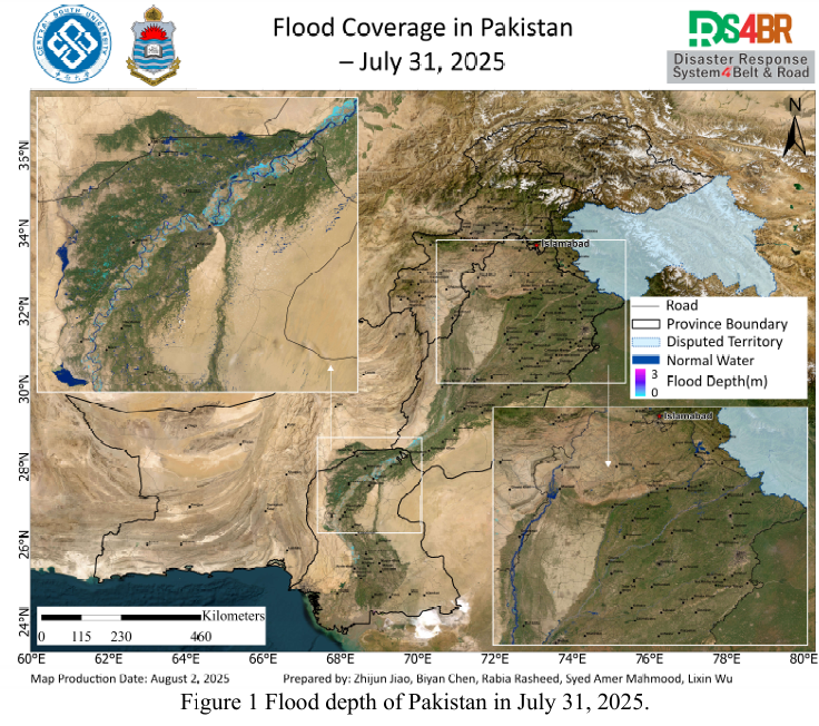
根据2025年7月16日至8月1日期间获取的Sentinel-1、Sentinel-2、Landsat-8、Landsat-9等多源遥感数据,结合KDFIMv2洪水反演算法,对巴基斯坦境内的洪水淹没范围与水深情况开展了动态监测与综合评估。图1展示了2025年7月31日的洪水水深空间分布图。结果显示,无论是洪水淹没范围还是水深情况均已显著减少,洪水整体处于明显退去阶段,仅在印度河流域部分区域存在季节性涨水现象,主要集中在河道内。图2为2025年8月1日的洪水淹没范...
Details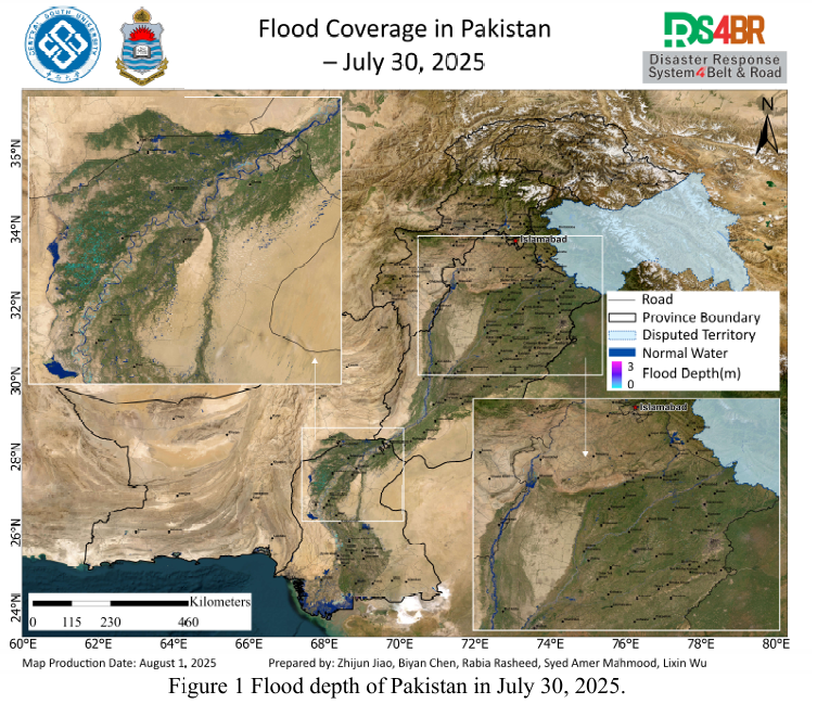
根据2025年7月16日至31日期间获取的Sentinel-1、Sentinel-2、Landsat-8、Landsat-9等多源遥感数据,结合KDFIMv2洪水反演算法,对巴基斯坦境内洪水淹没范围与水深开展了动态监测与综合评估。图1展示了2025年7月30日的洪水水深空间分布图。整体来看,淹没区域水深较浅,但主要河道内水深仍超过3米。信德省多数积水分布于农田区域,水深相对较低,反映出洪水正处于消退阶段。图2为2025年7月31日的洪水淹没范围图。由于遥感影像覆盖...
Details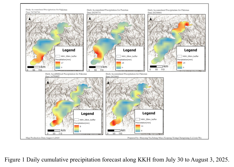
Combined with the precipitation forecast based on the NCFP GFS model on August 3, 2025 and multi-source data such as lithology, DEM and hydrological conditions along the Karakoram Highway, the TRIGRS model was adopted to conduct the landslide risk assessment in the northern area that was greatly affected by rainfall. The NCEP GFS precipitation forecast indicates that on August 3rd, the rain...
Details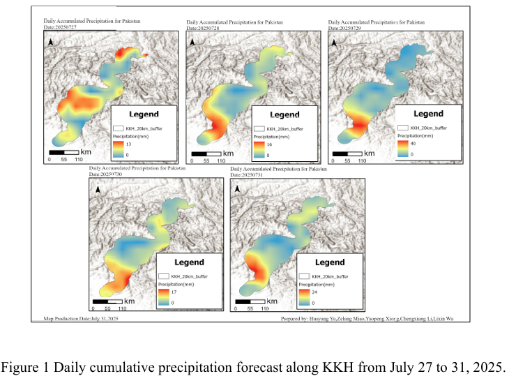
Combined with the precipitation forecast based on the NCFP GFS model on July 31, 2025 and multi-source data such as lithology, DEM and hydrological conditions along the Karakoram Highway, the TRIGRS model was adopted to conduct the landslide risk assessment in the northern area that was greatly affected by rainfall. The NCEP GFS precipitation forecast indicates that on July 31st, the rainfa...
Details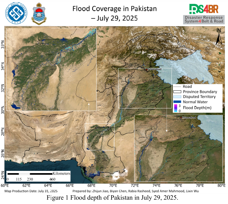
Based on multi-source remote sensing data acquired between July 16 and 30, 2025, including Sentinel-1, Sentinel-2, Landsat-8, and Landsat-9, combined with the KDFIMv2 algorithm, a dynamic monitoring and comprehensive assessment of flood inundation extent and water depth across Pakistan has been conducted.Fig. 1 illustrates the spatial distribution of flood water depth on July 29, 2025. The ...
Details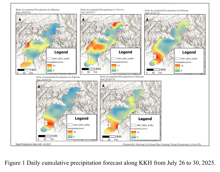
Combined with the precipitation forecast based on the NCFP GFS model on July 29, 2025 and multi-source data such as lithology, DEM and hydrological conditions along the Karakoram Highway, the TRIGRS model was adopted to conduct the landslide risk assessment in the northern area that was greatly affected by rainfall. The NCEP GFS precipitation forecast shows that the rainfall along the Karak...
Details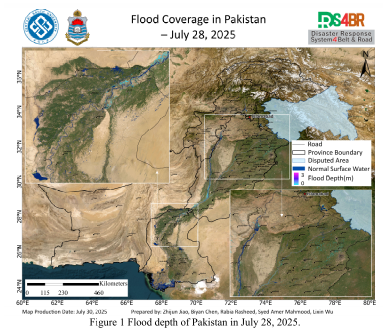
Based on multi-source remote sensing data acquired between July 16 and 29, 2025, including Sentinel-1, Sentinel-2, Landsat-8, and Landsat-9, combined with the KDFIMv2 algorithm, a dynamic monitoring and comprehensive assessment of flood inundation extent and water depth was conducted across Pakistan.Fig. 1 illustrates the spatial distribution of flood water depth on July 28, 2025. The analy...
Details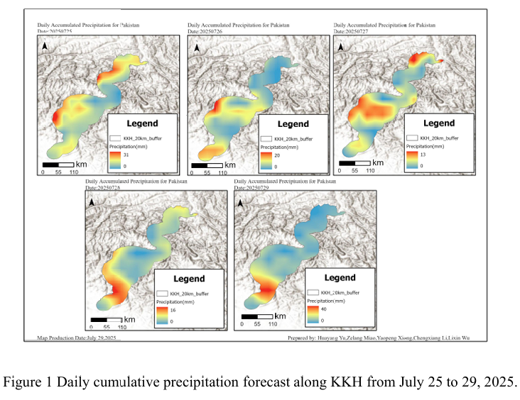
Combined with the precipitation forecast based on the NCFP GFS model on July 29, 2025 and multi-source data such as lithology, DEM and hydrological conditions along the Karakoram Highway, the TRIGRS model was adopted to conduct the landslide risk assessment in the northern area that was greatly affected by rainfall. The NCEP GFS precipitation forecast shows that the rainfall along the Karak...
Details
Based on multi-source remote sensing data acquired from July 16 to 28, 2025, including Sentinel-1, Sentinel-2, Landsat-8, and Landsat-9, a dynamic flood monitoring and comprehensive assessment was conducted across Pakistan using the KDFIMv2.Fig. 1 presents the spatial distribution of floodwater depth on July 27, 2025. The results indicate that the flood situation has significantly abated, with ...
Details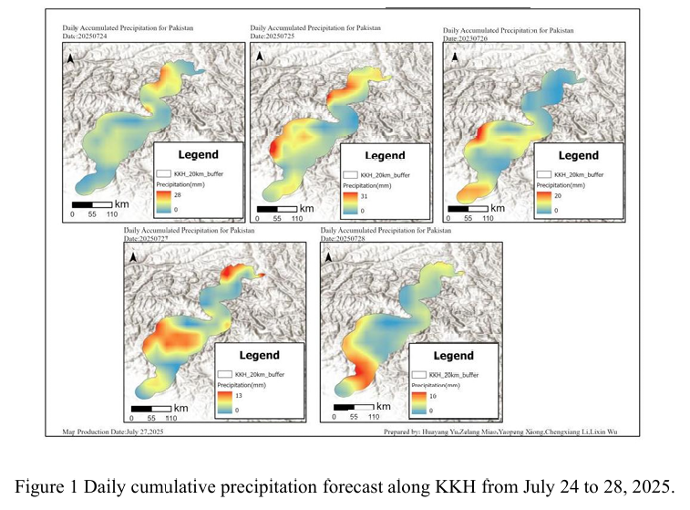
Combined with the precipitation forecast based on the NCFP GFS model on July 28, 2025 and multi-source data such as lithology, DEM and hydrological conditions along the Karakoram Highway, the TRIGRS model was adopted to conduct the landslide risk assessment in the northern area that was greatly affected by rainfall. The NCEP GFS precipitation forecast shows that on July 28th, there will be ...
Details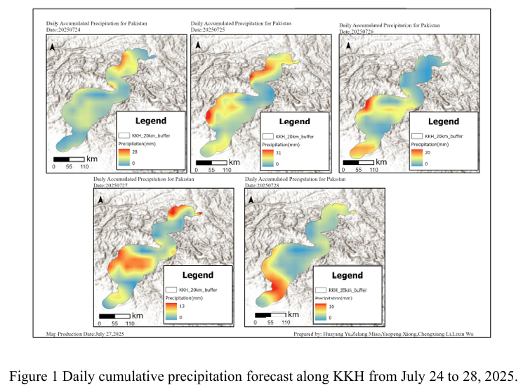
Combined with the precipitation forecast based on the NCFP GFS model on July 27, 2025 and multi-source data such as lithology, DEM and hydrological conditions along the Karakoram Highway, the TRIGRS model was adopted to conduct the landslide risk assessment in the northern area which is greatly affected by rainfall. NCEP GFS precipitation forecast shows that there will be less rainfall alon...
DetailsCopyright © 2025. DRS4BR All rights reserved.